Showing posts with label Environmental Science Journal Impact Factor. Show all posts

Monday, 6 January 2020

Lupine Publishers| Focusing on Food Security or Targeting the Economy: A Study on Maize and Cotton Production in Kandi Commune

Lupine Publishers- Environmental and Soil Science Journal


Abstract

Maize and cotton are two crops that are highly produced in North Benin. Their production has advantages as well as constraints. These advantages and constraints are taken into account in the choice of the producer to cultivate one of them. The objective of this study is to present, at first, the advantages and constraints that the producers of Kandi commune face on these two crops. It also aims to expose the producers’ preference according to the advantages and constraints listed by them. To achieve this, the data were collected in two districts of the municipality over a period of two weeks. Semi-structured interviews were conducted with fifty producers through an interview guide. Data processing was carried out using a dual approach (quantitative and qualitative) which, on the one hand, consisted in carrying out statistical tests and, on the other hand, analyzing the statements collected during the data collection. The main statistical test used in this study is Kendall’s W-concordance test, which has been used to prioritize constraints. At the end of the analyses, it appears that cotton, just like corn, enables producers to meet the needs and social development of their households. On the other hand, the non-organization of the maize sector, the lack of inputs and the delay in their distribution, maize prices fluctuation and difficulties in the evacuation of cotton are the main constraints reported by producers. Despite its lack of organization and the other constraints to which it is subject, maize crop is the most preferred. In view of this, it would be appropriate to consider the organization of the maize sector and the optimization of the services provided by the organizations in charge of the cotton sector. This will be beneficial to both production systems and also to all actors involved.

Introduction

Agriculture is one of the crucial activities that human being cannot neglect for his survival. It keeps the human species alive and contributes to its evolution. In Benin, it plays a great role in strengthening the economy and provide about 75% of jobs [1]. Among all the crops produced in the territory, two prove to be vital both in the constitution of the national economy and in the fight for food security: Those are corn and cotton. Known as the main cash crop in Benin [2] and the engine of the Beninese economy [3], cotton alone counts for 27% of exports and contributes by 7% to the national GDP. Its production has not stopped growing over the last five years. It reached in 2016, a tonnage of 451,000, which is an increase of more than 70% from the year 2015 [4]. Due to its multiple outlets, the cotton sector remains the country’s best organized sector [5]. If cotton receives a lot of attention from the Beninese government, corn itself does not have such a privilege. Nevertheless, it is the crop that could be an alternative to cotton production [6] in northern Benin. It comes second, after cotton as a subsistence and cash crop [7]. Indeed, its cultivation occupies nearly 70% of the total area devoted to cereals in Benin and represents about 75% of cereal production [8]. Together with cowpea, cassava and yam, it forms the staple crops of people’s diet [9]. Studies have shown that 63.1% of households in Benin consume 7 days out of 7, maize being the main cereal in the food ration [9]; [10]. Apart from the aspects raised, corn also has medicinal properties. According to [11], the corncob is used in combination with other plants to cure knee and low back pain. Some use it to treat diseases such as malaria.

Material and Methods

Study Area

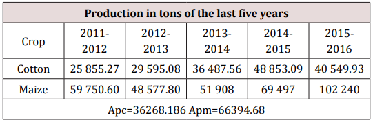
The study took place in the municipality of Kandi, county town of the department of Alibori. Located in the agro ecological zone of the cotton pan, it is limited by the communes of Malanville (North), Gogounou (South) Ségbana (East) and Banikoara (West). It is spread out an area of 3421Km2 and includes ten districts, sixty-seven villages and fifteen districts. The climate in Kandi is of Sudanese type characterized by two seasons that follow each other: The first, rainy from May to October and the second, dry from November to April. Climate change in sub Saharan Africa does not leave the Kandi commune on the side-lines. It is worth noting since a few decades in the commune and its surroundings an early drying up and a late or sometimes violent arrival of rains. Several studies carried out in the region have noted this [12-15]. In addition, the soil found at Kandi is of tropical ferruginous type. The relief is made up of plateau and one distinguishes by place hills made of granites and quartzite. As for vegetation, the town has grassy savanna, shrub and trees with some gallery forests. In terms of agricultural production, Kandi has a good reputation coming in second place after Banikoara, the giant cotton supplier in Benin. Apart from this asset, the municipality is essential in the department in terms of corn production. The following table gives an idea of the evolution of these two crops from 2011 to 2016 (Table 1).
Table 1: Production in tons of the last five years.
lupinepublishers-openaccess-journal-environmental-soil-sciences
Analysis of this table shows a peak of cotton and maize production between 2014 and 2016 with a respective tonnage of 48853.09 and 102240. The respective average production of the two crops is 362681.86 and 66394.68 tons.

Methodological Approach

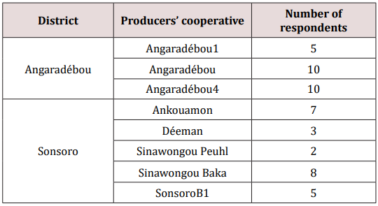
Among the ten districts of Kandi commune, only two were chosen to shelter the study. These are the districts of Angaradébou and Sonsoro. This choice was made in a participatory way with the coordinator of the Interprofessional Association of Cotton Producers. Firstly because of their performance in the production of both crops within the municipality and secondly because of their positioning. This choice was made for a wide variation of collected data and the obtaining of a socio cultural diversity in order to better touch the realities of the producers of Kandi as a whole. The data was collected using an interview guide designed to collect qualitative and quantitative data. The collection took place during the month of April of the year two thousand and eighteen (2018) and lasted 2 weeks. After an individual interview with five producers, the questionnaire underwent a slight adjustment. Faced with the unavailability of some farm managers, other people who were relatively close to them and involved in the farming activities of the households proved to be able to provide the necessary information for the study. A total of 25 subjects per district producing maize and cotton were included in the study. These have been identified by secretaries of cooperatives who hold leadership positions within their community. The following Table 2 provides an overview of the structure of the sample considered in the study.
Table 2: Structure of the study sample.
lupinepublishers-openaccess-journal-environmental-soil-sciences

Data Analysis

The data capture and analysis was carried out exclusively with SPSS v21.0 32bits software. The data processing was done using descriptive statistics, speech analysis and Kendall’s W-concordance test. The descriptive statistics essentially allow to obtain the frequencies and average of variables characterizing from a social and demographic point of view the interviewed farmers. The comments received from producers were analyzed and then used to model the “benefits and constraints” section. This technique was chosen inspired by the work of several authors including [16- 18]. The Kendall’s W-concordance test was also used to prioritize production constraints in order of importance.

Results

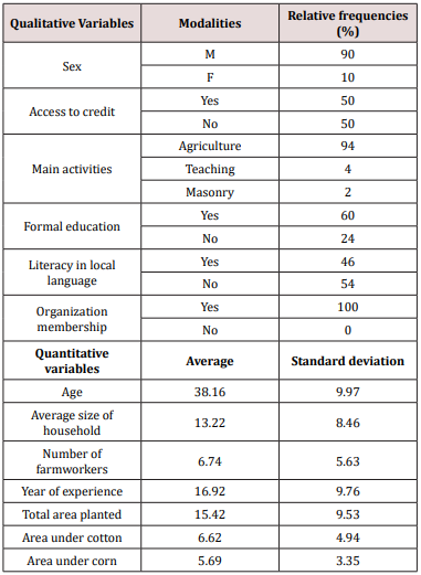
Table 3 below summarizes the socio-demographic characteristics of the producers surveyed in this study. It indicates that the subjects included in the sample are predominantly male (90%) with a low representation of women (10%). Ninety-four per cent of them live entirely depending on agriculture, compared to six per cent who make it as a secondary activity. Their farming experience varies from 3 to 40 years with an average of 16.92 years. Compared to the size of farm households in both localities (13 persons), the average number of farm active Worker (7 approximately) is relatively small. Farmers send their children to school until they are unable to move on. Sixty percent received formal education and forty percent got literate in local languages. Among those who have been literate 22% hold the certificate of primary school, 10% hold the certificate of secondary school and 2% hold the high school diploma and bachelor’s degree. Anyone wishing to cultivate cotton is required to belong to a Village Cooperative of Cotton Producers, this justifies the membership to an organization unanimously own by the respondents. The average area of cotton planted is 6.62 ha on an average total area of 15.62 ha. In contrast, the average area of maize grown is 5.69 ha. An observation of these figures allow to say that the cotton takes with a small difference, the top on the corn in terms of cultivated area in the commune. This could be explained by the several constraints faced by corn producers. Note that these results are quite similar to those obtained by [19] in their studies in the same commune. able 2: Structure of the study sample ese two crops from 2011 to 2016.
Table 3: Socio-demographic characteristics.
lupinepublishers-openaccess-journal-environmental-soil-sciences

Advantages

Advantages Related to Cotton Production

Cotton plays a major role in the lives of Kandi producers. From the exchanges held with the 50 people surveyed, it appears that several benefits are derived from the production of cotton. It allows heads of households and farms to make investments (buying cattle for traction, rolling stock, building houses ...), to perform ceremonies (marriage, baptism, burial ...) and then to meet regular expenses in their households and farms (schooling, food, expenses and debts of agricultural campaigns). The Interprofessional Cotton Association known as ‘’AIC’’ is the structure in charge of the cotton sector throughout the national territory. It has set in place a mechanism that allows producers to get inputs on credit before the campaign. They receive the inputs on credit, use them for production, and subsequently pay their debts at the time of payment. This approach is appreciated by the producers because, they lack sufficient financial means at the time of starting the campaign. Through the comments transcribed below, two producers support what has been said above. “The cash of cotton appears for me like a tontine, it allowed me to buy my bike, to build the house where I live. Thanks to the cotton I bought a ginning machine that serves me a lot after the corn harvest. My eldest son is already old enough to marriage. I need to buy him a motorcycle and prepare for his wedding by next year. It is on the cash of the cotton that I count to be able to do it. “ “The cash we get from cotton also allows us to do ceremonies. It is an obligation for us. In our culture, when someone close to your family dies, that means that your money is dying too. You cannot have money hidden somewhere without doing it. It’s like a duty for us.

Advantages Related to Maize Production

Corn in the first place ensures the food needs of households and the farm. After production, much of the crop is set aside to allow the producer, his family and those who serve him to overcome hunger, one of Maslow’s primary human needs. In the same way, the seeds used by the producers are taken from the previous crops. Apart from these two aspects, a great part of the producers have said that corn helps them financially. In fact, after harvest they reserve a larger portion for commercial purposes. The main reason behind this, is to cover regular expenses and household contingencies. These unforeseen events are usually cases of illness or death. Growing maize for the farmer is therefore a way to keep his relatives in safe from the food and financial point of view. The comments collected on this issue were analyzed and reissued below. “Corn helps us a lot, that’s what we eat at home almost all the time. In the form of dough, boiled, and akassa (local meal made with corn). When we are facing a financial problem we just have to take a bag of maize, sell it and the problem is solved. “Cotton’s cash lasts before coming. All the while, it’s corn that keeps us alive. Corn helps us a lot without lying to you.”

Cotton Production Constraints

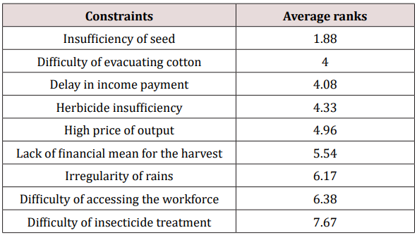
The benefits of cotton and corn production are enormous. However, during the survey, producers listed a number of constraints they face every day. Seven main constraints came back during the exchanges. They have been grouped in the following table with their respective average ranks. It is noted after analysis of the table that the main constraint reported by the population studied is the insufficiency of the seeds supplied to them. The majority of producers have not only deplored the lack of seeds but also the late availability of these inputs. Similarly, the removal of seed cotton, the late payment of cotton costs, the inadequacy of herbicides and the high cost of inputs are the secondary constraints recorded in this study. It is also important to note through the Kendall coefficient (0.379) that the order of importance of these constraints varies quite remarkably from one producer to another (Table 4).
Table 4: Classification of constraints related to cotton production.
lupinepublishers-openaccess-journal-environmental-soil-sciences

Corn Production Constraints

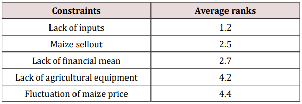
Concerning corn production constraints, there is a relatively high degree of agreement on the ranking (Kendall’s coefficient = 0.698). The first three constraints recorded are the lack of specific inputs for maize, the obligation to sell cheap the crops, and the lack of financial means to cover the expenses inherent to production. The lack of agricultural equipment and the fluctuation of the price of maize occupy the last places in this ranking (Table 5).
Table 5: Classification of constraints related to corn production.
lupinepublishers-openaccess-journal-environmental-soil-sciences

Corn or Cotton

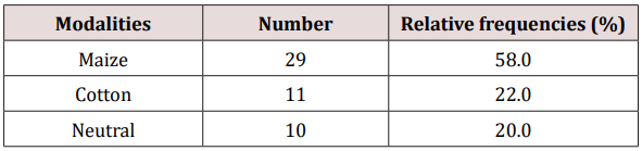
The objective of this section is to expose the respondents’ position after having simulated a situation where they are faced with making a choice between the two crops. It also aims to explain the reasons justifying their respective positions. Table 6 presents the distribution of producers according to the crop chosen. From this table, it appears that more than half of the producers (58%) chose corn, 22% cotton and 20% decided not to take a position. Table 7 below is a summary of the reasons given by the producers following the choice made. Producers, who opted for cotton justify their choice by the fact that the sector is organized, the price is fairly stable, and inputs are provided on credit. At the same time, those who chose maize justify this by its ability to cope with the producer’s financial problems, its ability to keep them alive before the arrival of cotton revenue and also by its easiness and short production cycle. Producers who have maintained a neutral stance argue that the two crops are inseparable and that in the current context, corn production is necessary in order to reap the benefits of cotton.
Table 6: Crop chosen by farmers.
lupinepublishers-openaccess-journal-environmental-soil-sciences
Table 7: Summary of the reasons given by the producers following the choice made Farmer stances.
lupinepublishers-openaccess-journal-environmental-soil-sciences

Discussion

As maize is a foodstuff, it is mainly used to cover the food needs of producers and their households. The forms under which it is consumed differ from one region to another, or even from one social category to another [20]. In Kandi commune, it is consumed in the form of porridge, paste and akassa. Secondarily, it is the subject of a commercial transaction and generates significant income for producers. After discussions with these producers, it is noted that the income earned is used for security purposes and social fulfilment. Purchases of food, buildings and ceremonies (marriage, baptism, death ...) are the main uses made of these incomes. They also, but very rarely, invest money that can add value to their production. Purchasing production equipment is generally limited to the minor tools that are necessary. This could be explained not only by the relatively large size of households living at the expense of these incomes, but also by the primacy of physiological and security needs over other needs. The difficulties that undermine the maize sector in the municipality are enormous, as well as the benefits that result from it. The lack of specific maize inputs outweighs all constraints by unlawfully resorting to inputs for cotton production. According to [5]; [7] and [21], this diversion is reflected in the low yields obtained at the cotton level. One could say that maize seems to be in the study area a parasite of the cotton crop. Studies conducted by [22] on the corn seed production and distribution system in accordance with this study revealed that the lack of input is one of the main weaknesses of the maize sector. The study also shows that, apart from the lack of inputs, the sale at low prices of harvests is a strategy developed by producers in urgent need of financial means. They are often lacking when they harvest the cotton. Cases of illness or other unforeseen events arise occasionally. In response to these problems, they sell corn crops. Those who do not adhere to this practice generally resort to Micro Finance Institutions (MFIs) loans as mentioned by [23]. The ‘‘warrantage’’, (a sort of securing by storing a part or the full harvest) implemented in Benin for more than a decade [24] in response to this situation hasn’t unfortunately had a significant impact in the study area. With regard to cotton, it is noted that income from production has the same purpose as corn, with the difference that cotton is exclusively sold and used more for sustainable projects. In some localities in the study area, cotton producers pay contributions after receiving cotton income to build classrooms or other community infrastructures. Numerous producers greet the organization around the cotton sector and mainly the credit-input which is granted to them. This credit would allow them, according to [25], to effectively fight against pests and raise the level of fertility of their land. Nevertheless, the high cost of inputs, the insufficiency of seeds supplied and especially the delay in their delivery are denounced as the real handicaps of the sector. Many are forced to informally leave money in order to have the extra amount of seed needed. Added to this, the evacuation of cotton harvests from the production areas to the factory loses its nature of gratuity at a given period of the campaign. All these constraints call into question the performance of the production system.

Conclusion


The aim of this study was to shed light on the two most important agricultural value chains in northern Benin. This, through the advantages and constraints that characterize their productions. At the end of the study, it appears that cotton as much as maize represents a lot. farmers. Corn is the staple of their diet and significant revenues are derived from the production of both crops. These revenues are mainly used to meet the needs of households and their social development. Cotton, on the other hand, enables producers to meet their economic and social needs. Besides, the two production systems are subject to constraints that need to be considered for the betterment of these sectors and the actors involved. Giving common attention to both crops through the organization of the maize sector and the optimization of the services provided by the AIC are means likely to boost the satisfaction of all the actors involved. 

For more Lupine Publishers Open Access Journals Please visit our website:
For more Open Access Environment Journal articles Please Click Here:
To Know More About Open Access Publishers Please Click on Lupine Publishers


Follow on Twitter   :  https://twitter.com/lupine_online


Tuesday, 3 December 2019

Lupine Publishers | Focusing on Food Security or Targeting the Economy: A Study on Maize and Cotton Production in Kandi Commune

Abstract

Maize and cotton are two crops that are highly produced in North Benin. Their production has advantages as well as constraints. These advantages and constraints are taken into account in the choice of the producer to cultivate one of them. The objective of this study is to present, at first, the advantages and constraints that the producers of Kandi commune face on these two crops. It also aims to expose the producers’ preference according to the advantages and constraints listed by them. To achieve this, the data were collected in two districts of the municipality over a period of two weeks. Semi-structured interviews were conducted with fifty producers through an interview guide. Data processing was carried out using a dual approach (quantitative and qualitative) which, on the one hand, consisted in carrying out statistical tests and, on the other hand, analyzing the statements collected during the data collection. The main statistical test used in this study is Kendall’s W-concordance test, which has been used to prioritize constraints. At the end of the analyses, it appears that cotton, just like corn, enables producers to meet the needs and social development of their households. On the other hand, the non-organization of the maize sector, the lack of inputs and the delay in their distribution, maize prices fluctuation and difficulties in the evacuation of cotton are the main constraints reported by producers. Despite its lack of organization and the other constraints to which it is subject, maize crop is the most preferred. In view of this, it would be appropriate to consider the organization of the maize sector and the optimization of the services provided by the organizations in charge of the cotton sector. This will be beneficial to both production systems and also to all actors involved.


Introduction

Agriculture is one of the crucial activities that human being cannot neglect for his survival. It keeps the human species alive and contributes to its evolution. In Benin, it plays a great role in strengthening the economy and provide about 75% of jobs [1]. Among all the crops produced in the territory, two prove to be vital both in the constitution of the national economy and in the fight for food security: Those are corn and cotton. Known as the main cash crop in Benin [2] and the engine of the Beninese economy [3], cotton alone counts for 27% of exports and contributes by 7% to the national GDP. Its production has not stopped growing over the last five years. It reached in 2016, a tonnage of 451,000, which is an increase of more than 70% from the year 2015 [4]. Due to its multiple outlets, the cotton sector remains the country’s best organized sector [5]. If cotton receives a lot of attention from the Beninese government, corn itself does not have such a privilege. Nevertheless, it is the crop that could be an alternative to cotton production [6] in northern Benin. It comes second, after cotton as a subsistence and cash crop [7]. Indeed, its cultivation occupies nearly 70% of the total area devoted to cereals in Benin and represents about 75% of cereal production [8]. Together with cowpea, cassava and yam, it forms the staple crops of people’s diet [9]. Studies have shown that 63.1% of households in Benin consume 7 days out of 7, maize being the main cereal in the food ration [9]; [10]. Apart from the aspects raised, corn also has medicinal properties. According to [11], the corncob is used in combination with other plants to cure knee and low back pain. Some use it to treat diseases such as malaria.

Material and Methods

Study Area

The study took place in the municipality of Kandi, county town of the department of Alibori. Located in the agro ecological zone of the cotton pan, it is limited by the communes of Malanville (North), Gogounou (South) Ségbana (East) and Banikoara (West). It is spread out an area of 3421Km2 and includes ten districts, sixty-seven villages and fifteen districts. The climate in Kandi is of Sudanese type characterized by two seasons that follow each other: The first, rainy from May to October and the second, dry from November to April. Climate change in sub Saharan Africa does not leave the Kandi commune on the side-lines. It is worth noting since a few decades in the commune and its surroundings an early drying up and a late or sometimes violent arrival of rains. Several studies carried out in the region have noted this [12-15]. In addition, the soil found at Kandi is of tropical ferruginous type. The relief is made up of plateau and one distinguishes by place hills made of granites and quartzite. As for vegetation, the town has grassy savanna, shrub and trees with some gallery forests. In terms of agricultural production, Kandi has a good reputation coming in second place after Banikoara, the giant cotton supplier in Benin. Apart from this asset, the municipality is essential in the department in terms of corn production. The following table gives an idea of the evolution of these two crops from 2011 to 2016 (Table 1).
Table 1: Production in tons of the last five years.
lupinepublishers-openaccess-journal-environmental-soil-sciences
Analysis of this table shows a peak of cotton and maize production between 2014 and 2016 with a respective tonnage of 48853.09 and 102240. The respective average production of the two crops is 362681.86 and 66394.68 tons.

Methodological Approach

Among the ten districts of Kandi commune, only two were chosen to shelter the study. These are the districts of Angaradébou and Sonsoro. This choice was made in a participatory way with the coordinator of the Interprofessional Association of Cotton Producers. Firstly because of their performance in the production of both crops within the municipality and secondly because of their positioning. This choice was made for a wide variation of collected data and the obtaining of a socio cultural diversity in order to better touch the realities of the producers of Kandi as a whole. The data was collected using an interview guide designed to collect qualitative and quantitative data. The collection took place during the month of April of the year two thousand and eighteen (2018) and lasted 2 weeks. After an individual interview with five producers, the questionnaire underwent a slight adjustment. Faced with the unavailability of some farm managers, other people who were relatively close to them and involved in the farming activities of the households proved to be able to provide the necessary information for the study. A total of 25 subjects per district producing maize and cotton were included in the study. These have been identified by secretaries of cooperatives who hold leadership positions within their community. The following Table 2 provides an overview of the structure of the sample considered in the study.
Table 2: Structure of the study sample.
lupinepublishers-openaccess-journal-environmental-soil-sciences

Data Analysis

The data capture and analysis was carried out exclusively with SPSS v21.0 32bits software. The data processing was done using descriptive statistics, speech analysis and Kendall’s W-concordance test. The descriptive statistics essentially allow to obtain the frequencies and average of variables characterizing from a social and demographic point of view the interviewed farmers. The comments received from producers were analyzed and then used to model the “benefits and constraints” section. This technique was chosen inspired by the work of several authors including [16- 18]. The Kendall’s W-concordance test was also used to prioritize production constraints in order of importance.

Results

Table 3 below summarizes the socio-demographic characteristics of the producers surveyed in this study. It indicates that the subjects included in the sample are predominantly male (90%) with a low representation of women (10%). Ninety-four per cent of them live entirely depending on agriculture, compared to six per cent who make it as a secondary activity. Their farming experience varies from 3 to 40 years with an average of 16.92 years. Compared to the size of farm households in both localities (13 persons), the average number of farm active Worker (7 approximately) is relatively small. Farmers send their children to school until they are unable to move on. Sixty percent received formal education and forty percent got literate in local languages. Among those who have been literate 22% hold the certificate of primary school, 10% hold the certificate of secondary school and 2% hold the high school diploma and bachelor’s degree. Anyone wishing to cultivate cotton is required to belong to a Village Cooperative of Cotton Producers, this justifies the membership to an organization unanimously own by the respondents. The average area of cotton planted is 6.62 ha on an average total area of 15.62 ha. In contrast, the average area of maize grown is 5.69 ha. An observation of these figures allow to say that the cotton takes with a small difference, the top on the corn in terms of cultivated area in the commune. This could be explained by the several constraints faced by corn producers. Note that these results are quite similar to those obtained by [19] in their studies in the same commune. able 2: Structure of the study sample ese two crops from 2011 to 2016.
Table 3: Socio-demographic characteristics.
lupinepublishers-openaccess-journal-environmental-soil-sciences

Advantages

Advantages Related to Cotton Production

Cotton plays a major role in the lives of Kandi producers. From the exchanges held with the 50 people surveyed, it appears that several benefits are derived from the production of cotton. It allows heads of households and farms to make investments (buying cattle for traction, rolling stock, building houses ...), to perform ceremonies (marriage, baptism, burial ...) and then to meet regular expenses in their households and farms (schooling, food, expenses and debts of agricultural campaigns). The Interprofessional Cotton Association known as ‘’AIC’’ is the structure in charge of the cotton sector throughout the national territory. It has set in place a mechanism that allows producers to get inputs on credit before the campaign. They receive the inputs on credit, use them for production, and subsequently pay their debts at the time of payment. This approach is appreciated by the producers because, they lack sufficient financial means at the time of starting the campaign. Through the comments transcribed below, two producers support what has been said above. “The cash of cotton appears for me like a tontine, it allowed me to buy my bike, to build the house where I live. Thanks to the cotton I bought a ginning machine that serves me a lot after the corn harvest. My eldest son is already old enough to marriage. I need to buy him a motorcycle and prepare for his wedding by next year. It is on the cash of the cotton that I count to be able to do it. “ “The cash we get from cotton also allows us to do ceremonies. It is an obligation for us. In our culture, when someone close to your family dies, that means that your money is dying too. You cannot have money hidden somewhere without doing it. It’s like a duty for us.

Advantages Related to Maize Production

Corn in the first place ensures the food needs of households and the farm. After production, much of the crop is set aside to allow the producer, his family and those who serve him to overcome hunger, one of Maslow’s primary human needs. In the same way, the seeds used by the producers are taken from the previous crops. Apart from these two aspects, a great part of the producers have said that corn helps them financially. In fact, after harvest they reserve a larger portion for commercial purposes. The main reason behind this, is to cover regular expenses and household contingencies. These unforeseen events are usually cases of illness or death. Growing maize for the farmer is therefore a way to keep his relatives in safe from the food and financial point of view. The comments collected on this issue were analyzed and reissued below. “Corn helps us a lot, that’s what we eat at home almost all the time. In the form of dough, boiled, and akassa (local meal made with corn). When we are facing a financial problem we just have to take a bag of maize, sell it and the problem is solved. “Cotton’s cash lasts before coming. All the while, it’s corn that keeps us alive. Corn helps us a lot without lying to you.”

Cotton Production Constraints

The benefits of cotton and corn production are enormous. However, during the survey, producers listed a number of constraints they face every day. Seven main constraints came back during the exchanges. They have been grouped in the following table with their respective average ranks. It is noted after analysis of the table that the main constraint reported by the population studied is the insufficiency of the seeds supplied to them. The majority of producers have not only deplored the lack of seeds but also the late availability of these inputs. Similarly, the removal of seed cotton, the late payment of cotton costs, the inadequacy of herbicides and the high cost of inputs are the secondary constraints recorded in this study. It is also important to note through the Kendall coefficient (0.379) that the order of importance of these constraints varies quite remarkably from one producer to another (Table 4).
Table 4: Classification of constraints related to cotton production.
lupinepublishers-openaccess-journal-environmental-soil-sciences

Corn Production Constraints

Concerning corn production constraints, there is a relatively high degree of agreement on the ranking (Kendall’s coefficient = 0.698). The first three constraints recorded are the lack of specific inputs for maize, the obligation to sell cheap the crops, and the lack of financial means to cover the expenses inherent to production. The lack of agricultural equipment and the fluctuation of the price of maize occupy the last places in this ranking (Table 5).
Table 5: Classification of constraints related to corn production.
lupinepublishers-openaccess-journal-environmental-soil-sciences

Corn or Cotton

The objective of this section is to expose the respondents’ position after having simulated a situation where they are faced with making a choice between the two crops. It also aims to explain the reasons justifying their respective positions. Table 6 presents the distribution of producers according to the crop chosen. From this table, it appears that more than half of the producers (58%) chose corn, 22% cotton and 20% decided not to take a position. Table 7 below is a summary of the reasons given by the producers following the choice made. Producers, who opted for cotton justify their choice by the fact that the sector is organized, the price is fairly stable, and inputs are provided on credit. At the same time, those who chose maize justify this by its ability to cope with the producer’s financial problems, its ability to keep them alive before the arrival of cotton revenue and also by its easiness and short production cycle. Producers who have maintained a neutral stance argue that the two crops are inseparable and that in the current context, corn production is necessary in order to reap the benefits of cotton.
Table 6: Crop chosen by farmers.
lupinepublishers-openaccess-journal-environmental-soil-sciences
Table 7: Summary of the reasons given by the producers following the choice made Farmer stances.
lupinepublishers-openaccess-journal-environmental-soil-sciences

Discussion

As maize is a foodstuff, it is mainly used to cover the food needs of producers and their households. The forms under which it is consumed differ from one region to another, or even from one social category to another [20]. In Kandi commune, it is consumed in the form of porridge, paste and akassa. Secondarily, it is the subject of a commercial transaction and generates significant income for producers. After discussions with these producers, it is noted that the income earned is used for security purposes and social fulfilment. Purchases of food, buildings and ceremonies (marriage, baptism, death ...) are the main uses made of these incomes. They also, but very rarely, invest money that can add value to their production. Purchasing production equipment is generally limited to the minor tools that are necessary. This could be explained not only by the relatively large size of households living at the expense of these incomes, but also by the primacy of physiological and security needs over other needs. The difficulties that undermine the maize sector in the municipality are enormous, as well as the benefits that result from it. The lack of specific maize inputs outweighs all constraints by unlawfully resorting to inputs for cotton production. According to [5]; [7] and [21], this diversion is reflected in the low yields obtained at the cotton level. One could say that maize seems to be in the study area a parasite of the cotton crop. Studies conducted by [22] on the corn seed production and distribution system in accordance with this study revealed that the lack of input is one of the main weaknesses of the maize sector. The study also shows that, apart from the lack of inputs, the sale at low prices of harvests is a strategy developed by producers in urgent need of financial means. They are often lacking when they harvest the cotton. Cases of illness or other unforeseen events arise occasionally. In response to these problems, they sell corn crops. Those who do not adhere to this practice generally resort to Micro Finance Institutions (MFIs) loans as mentioned by [23]. The ‘‘warrantage’’, (a sort of securing by storing a part or the full harvest) implemented in Benin for more than a decade [24] in response to this situation hasn’t unfortunately had a significant impact in the study area. With regard to cotton, it is noted that income from production has the same purpose as corn, with the difference that cotton is exclusively sold and used more for sustainable projects. In some localities in the study area, cotton producers pay contributions after receiving cotton income to build classrooms or other community infrastructures. Numerous producers greet the organization around the cotton sector and mainly the credit-input which is granted to them. This credit would allow them, according to [25], to effectively fight against pests and raise the level of fertility of their land. Nevertheless, the high cost of inputs, the insufficiency of seeds supplied and especially the delay in their delivery are denounced as the real handicaps of the sector. Many are forced to informally leave money in order to have the extra amount of seed needed. Added to this, the evacuation of cotton harvests from the production areas to the factory loses its nature of gratuity at a given period of the campaign. All these constraints call into question the performance of the production system.


For more Lupine Publishers Open Access Journals Please visit our website:
For more Open Access Environment Journal articles Please Click Here:
To Know More About Open Access Publishers Please Click on Lupine Publishers

Tuesday, 26 November 2019

Lupine Publishers | Selected Methods of Spatial Analysis of Soils of Azerbaijan

Lupine Publishers- Environmental and Soil Science Journal

Spatial analysis in GIS Wednesday is based on complex techniques, the results of which depend on the raw data. One of the fundamentals of spatial analysis techniques based on digital hypsometric model is the development of maps of the angles. She gained widespread use, from morphogenetic and geologicalengineering perspective to the agrarian and territorial planning.

Progress of Research and Discussion of Materials

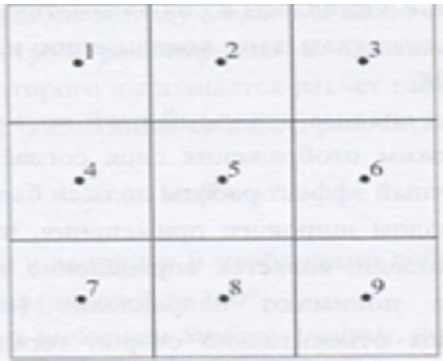
Program Arc Map provides the ability to quickly prepare this type of cards based on raster model hypsometric territory. To calculate the slope of a surface that is specific to a particular screen, used values of absolute height, raised eight surrounding screens (Figure 1). The calculated values of the two parameters (ɑ and (b)), proportional average slant of slope (respectively on the x and y axis) according to the following formulae:
Figure 1.
lupinepublishers-openaccess-journal-environmental-soil-sciences
ɑ = (h3+2h6+h9-h1-2h4 - (h)7 )/8L (1)

(b)=(h1+2h2+h3-h7-2h8 - (h)9 )/8L
Where is:
(h)1 = the absolute height of the surface of the territory in (i) -OM image according to (Figure 1).
L = raster measurement.
The angle of the slope, plant in the central point is cal
tan ɑ= √a2 + b2 (2).
a) In the menu Spatial Analyst pick Surfase Analysis, then Slopethat will lead to opening the window method.
b) With list boxes Input surface Choose created a digital model of the hypsometric of Azerbaijan.
c) The main unit can be marked graphs slope measurement slope on the resultant map-in variant degrees ( Degree) or as a percentage (option) Percent
d) Graphs Z Factor and Output cell size perform the same role as in the Hillshade. Leave them automatic size.
e) In the graph Output raster point localization and name of the source file, then- OK.
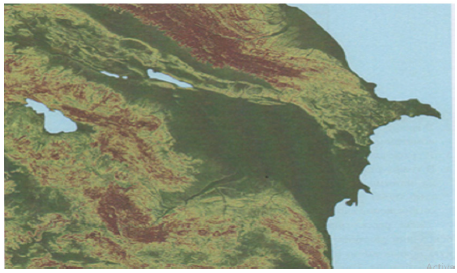
f) After completion of the analysis of the source layer appears in the map image.
g) Change the layer display mode according to the technique described previously.
h) The final effect should be similar to (Figure 2).
i) The following method of broad application that is based on digital hypsometric model is the definition of exposure [1].
Under slope Exposition, understand the direction (azimuth) slope steepness of most to the sides of the horizon.
Figure 2.Indexation Scheme of high-altitude points to calculate slope angles.
lupinepublishers-openaccess-journal-environmental-soil-sciences
This option is very important for those kinds of analysis that takes into account the difference of thermal balance of the northern and southern slopes.
This is the initial value for aspects such as the time of occurrence of snow cover duration of vegetation period etc. The method of calculation is similar to the method Slope . It also used high-altitude data from screens placed in the immediate vicinity of the Central screen, for which the calculation of parameters (a) and (b) (in accordance with identical formulas) [2].
Exposition of slopeis calculated as:
tan ß=a/b (3)
If (b) positively, the largest Add 180°, that allows to take into account the magnitude of the azimuth from 0 to 360°.
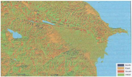
a) In menu Spatial Analyst choose a Surface Analysis, then Aspect-method dialog box appears (Figure 3)
Figure 3: Angular slopes map developed in accordance with method S lope based on a digital model of Azerbaijan hypsometric.
lupinepublishers-openaccess-journal-environmental-soil-sciences
b) In box Input surface traditionally make the filename digitally hypsometric model.
c) In box Output cell size leave unattended.
In box Output raster denote localization and name of the source file, click OK to start following their completion, payments to the image will be added effective map. After you change the display card is similar to (Figure 3). Next, consider the way to an integrated spatial analysis based on raster maps. For example, suppose you want to select a specific localization hypothetical potential investments on the territory of Azerbaijan. Investor demands that the investing territory meets certain conditions. First, the angle of the slopes in the territory’s investment should not exceed 10°. Secondly, the investment should be within the absolute height of surface from 100 to 500 mnm. Using GIS and digital hypsometric model of Azerbaijan (with derived layers), the definition of localizations of this investment takes a few minutes. In menu Spatial Analyst toolbar Select position Raster Calculator. A dialog box appears, represented in the left part of the window, in the Layers highlighted all raster layers project. With right sides are mathematical logical operators that can be used for entering formulas. The formulas are based on arithmetic operators, and the results have a numeric expression. For example, if you want to double increase digital hypsometric model, it is possible to formulate a simple expression: [CGM]. where instead of CGM, you must enter the name of the selected raster layer surface model. As a result of this operation received a raster map, where each point in discrete space is assigned a numerical value, which corresponds to doubling the height of the territory. Such arithmetic operations can be applied to other sectors. For example, having a layer of embossed field precipitation, as well as layer with spatial distribution of filtration coefficient, obtained by multiplying the two layers you can obtain the spatial distribution of effective infiltration of precipitation. Often also used the differencing method. In this way, create a differential maps that document the temporarily-spatial variability of the investigated phenomenon. For example, as a result of the seizure of average precipitation from the actual over the past two years, it is possible to define the territory increases and regression of this phenomenon [4-6].
Use this type of expression to identify the territory within Azerbaijan, which satisfies the conditions of investra. First define the territory where the inclination does not exceed slopes 100.
This requires the formulation of the next task
[Slope] < = 10. (4)
Where on the graph Slope you must submit the name of a bitmap layer with angles of inclination of slopes.
Formulation of issues using Windows Raster Calculator is simple enough:
i. In the graph Layers Select the name of the layer with the angles of inclination of slopes. Note that added layer automatically enclosed in quotation marks.
ii. Of the symbols of the operators choose < =. This results in adding this element to the expression.
Citation: RAE Aliyev ZH. Selected Methods of Spatial Analysis of Soils of Azerbaijan. Open Acc J Envi Soi Sci 1(1)- 2018. OAJESS.MS.ID.000103. 18 iii. Using digital signs in a window or on the keyboard, type 10 in the end of the expression.
iv. The formula is ready, you can go to to do so. Evaluate.
Upon completion of the calculations in the working area of the project will add a new layer using the program Calculation . Layer is only with greatness and 0 1.
Screens marked digital 1, satisfy the conditions of maximum slope slopes up to 10 largest° . Now you must select the area that meets the requirements of investra for its absolute height. To do this, construct the following expression (5) [7-10]:
[CGM] > = 100 and [CGM] < = 500 (5)
On site CGM enter the name of a raster layer with digital hypsometric model territory. For formulating expressions use window Raster Calculator .
a) In Windows Raster Calculator Select layer with digital hypsometric model of Azerbaijani territory in the graph Layers.
b) press the key with the operator > =
c) Enter the value 100
d) Push And
e) Again click on the layer name in the CGM graph Layers.
f) Push the button with the < = operator
g) Enter the value 500
h) Check the correctness of the formula and select Evaluate.
The result of the calculations is a raster layer named program Calculation . 2. similar to the previous layer here showing screens marked cifroj1 that identify the territory, where high-rise relevant criteria. now you must connect both layers to define the territory corresponding to two requirements-surface height and tilt. Use the method the Raster Calculator [11-12].
a) press twice on the layer Calculation in the graph Layers.
b) Select the = operator
c) Enter the value 1.
d) Choose the logical operator And
e) twice click on layer Calculation2.
f) Select the = operator
g) Enter the value 1.
h) The final expression must be of the form:
[Calculation] = 1 & [Calculation2] = 1
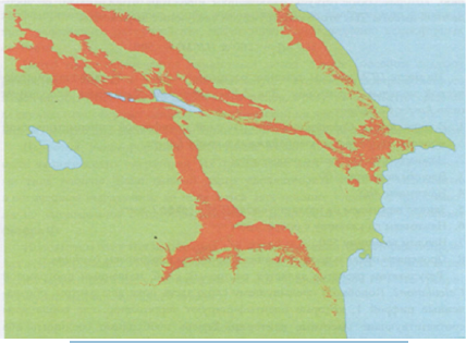
i) Click on Evaluate. In the working area will be added a new layer with the designated (red) territory, which satisfies the requirements of the investor (Figure 4) [13-15].
Figure 4: Map of exposures of the slopes, developed based on digital hypsometric put Azerbaijan.
lupinepublishers-openaccess-journal-environmental-soil-sciences
The resulting image points to a very extensive array, located in the foothill zone of Azerbaijan. It is clear that in such a large territory does not satisfy any investor to potential localization object. In this regard, you can narrow the boundary parameters of each criterion. For example, the choice of the territory where the inclination does not exceed 1 degree. In the analysis process can also take into account additional criteria, such as location, investment plot at a distance of not less than 500 m from the nearest coastline and 1000 m from the urban areas (Figure 5). The possibilities are endless and depend solely on the needs of the user of GIS and spatial information availability [15-18].
Figure 5: Result of the spatial analysis to define the territory of Azerbaijan, the relevant requirements of the investor.
lupinepublishers-openaccess-journal-environmental-soil-sciences


For more Lupine Publishers Open Access Journals Please visit our website:
For more Open Access Environment Journal articles Please Click Here:
To Know More About Open Access Publishers Please Click on Lupine Publishers

Wednesday, 20 November 2019

Lupine Publishers | Is the salvation of life on the planet?


Lupine Publishers- Environmental and Soil Science Journal


Before the advent of modern industry, nature had tangible additions in the composition of atmospheric water vapor natural evaporation from transpiration of plant and natural emissions, in particular, from the respiration of creatures, animal worlds. Every living being, every plant in its secretions, at the molecular level, in its secretions creates information about itself. It is known that in the exhalation of a living being in the moisture of breathing, in any secretions, information is contained. It is proved by the fact that animals determine their victims and the opposite sex by smells. Plants allocate their personal phytoncides. Phytoncides are all volatile substances released by plants, including those that are practically impossible to collect in appreciable amounts. These phytoncides are also called “native antimicrobial substances of plants http://stgetman.narod.ru/fitoncid.html. We all enjoy the smells of flowers, coniferous forests, shrubs.
Medicine has such achievements that it is possible to diagnose his illnesses according to the exhalation of a person. https://www. golos-ameriki.ru/a/254391.html The diagnosis of exhalation is the latest achievements of medicine, a revolution in oncology. Inspectors of road safety services for smell movement and appliances determine the state of alcohol status of the driver of the vehicle.All these smells and volatile substances are formed inside the living organism as a result of the most complicated chemical transformations. We also know that water has a different molecular structure and carries information. Maybe this information is preserved in evaporation? For example, in the works of the famous Japanese scientist Emoto Mazaru, it is clearly defined how ice crystals change depending on sound and even mental effects on water. Proceeding from this, it can be concluded that evaporation from organic matter also has certain properties and, accumulating in the atmosphere, creates certain conditions. It is these conditions that form the volumes of subsequent precipitation, the location of their distribution, and the graphs of precipitation.
A man with his civilization influences the path of organic transformations, or rather destroys a whole link in the everlasting path of water food chains. This is asphalt, arable land, surface water bodies, landfills. According to the area of the entire land area of the planet, such territories became 63 percent for 2015, which are expanding with the development of technologies with increasing acceleration. Even greater evaporation produces man from production and communal industries. Water coming from the water pipe evaporates in millions of evaporators, heaters, sinks, dryers from each rag, from each washed cup without changing the structure in the organics. These are evaporation unknown to the nature, let’s call them artificial.Nothing in nature is done just like that. Nothing never disappears anywhere and does not appear anywhere. What is the further path of artificial fumes? What is their structure, what is their volume and what is the speed of such evaporation. We feel it ourselves. They rise in the sky in huge volumes, they permanently cover the sun. They fall out incredible precipitation in some places, and do not carry drops into others. The mechanism of rational circulation has disappeared. This is no longer a cycle of water in nature, but a cycle of artificial fumes. Nature is powerless to control such volumes and such velocities.
It follows that organic evaporation, uniting in the clouds, synthesizes a certain substance, some special property that somehow forms the temperature, volume, shape, quality of the surface atmosphere. Interacting with the biota for millions of years, a certain cycle of substances between the atmosphere and the soil has stabilized. The quality, the amount of precipitation, the places of their condensation, movement in geographic space and loss all this was polished in a single process. This explains the creation and distribution of all natural areas from deserts to the tropics.From here we get droughts in some areas, floods in others. Destroyed, created by millions of years, the mechanism of atmospheric phenomena. In effect, the destruction of just one link in the circuit of water on the planet led to the creation of an entirely new atmospheric mechanism - the circulation of artificial fumes, a new source of natural disasters, to climate change.

Is There a Possibility of Salvation?

The Paris Agreements of 2015, “green technologies”, alternative energy sources - this is an intuitive direction created by mankind to conserve nature. Right direction. But only these are microscopic steps. Moreover, these steps lead to a catastrophe, diverting the efforts of mankind to preserve life.
The only true direction to preserving life on the planet is the movement to reduce artificial and return natural vapors. If we want to preserve life on the planet, we must begin to restore the nature of the cycle of water selected from it to nature.
A new concept for stopping climate change should be developed. The main elements of this are
a) Complete and unconditional stopping of projects and construction of all types of works with the partitioning of rivers, the laying of new channels
b) Global water saving in everyday life and production of all products by every person, every production of all countries and continents
c) Maximum possible rapid relocation of all types of production , the infrastructure of cities and the very housing under the ground.

For more Lupine Publishers Open Access Journals Please visit our website:
For more Open Access Environment Journal articles Please Click Here:
To Know More About Open Access Publishers Please Click on Lupine Publishers

Follow on Twitter   :  https://twitter.com/lupine_online

Friday, 8 November 2019

Lupine Publishers | Review of the Effect of Climatic Conditions to the Development of Erosion Process in Soils of Azerbaijan


Lupine Publishers- Environmental and Soil Science Journal


Abstract

The Researchers proved that the process of soil erosion is also closely linked to climatic conditions of the region. Therefore, depending on the climatic conditions of the erosive processes are different in both forms of its manifestation, and the quantitative indicators of development. For example, in the north-eastern part of the Greater Caucasus Highlands powerful deposition of snow cover, high intensity of spring melting of snow and summer rain water rainfalls the calling intensive lavages and size of its development areas. But here, against a backdrop of high air temperatures during the growing season, pronounced wind regime and extremely low relative humidity of the air is wind erosion. Climate also affects the surface configuration. Humid areas where vegetation cover protects the soil from severe manifestations of water and wind erosion, characterized by soft, rounded slopes.

Introduction

Soil erosion is an ongoing process, which consists in moving soil mass from one place to another, under the influence of water, wind and gravity [1]. Among the numerous classifications, organize my erosive phenomenon, the most important is the separation of erosion: natural (caused by forces of nature) and accelerated (caused by human activities). Erosion processes caused by forces of nature (wind, water and gravity erosion), the largest scale in a glacial period when the vegetation was negligible. The emergence of higher (herbaceous and woody) plants heavily restricted and even helped to overcome the action of erosion processes, accelerate soil formation processes and soil formation [1,3]. Human activities (agriculture (agronomy) erosion) is the main factor which contributes to development and an increase in the intensity of erosion processes, collapsing the Earth’s mainland surface, which led to the significant in terms of size, soil degradation, reducing, and even destruction of its productive capacity, compared with natural conditions [2].
Figure 1: Map of erosion risk soils of Azerbaijan.
lupinepublishers-openaccess-journal-environmental-soil-sciences


Progress in the Study and Discussion of Materials

(Economic), from a practical point of view stands out-a potential erosion described as erosion risk and actual (current) erosion, described as erosive damage in mostly size floating soil masses (in mm thickness or t/ha or km2). Along with that, in areas with dry climates where the water flows very fast and where the wind taking sand particles and working them as cutter, erases the surface and sweeps weathering products typical of sharply defined overskirt. When examining the erosion problem is extremely important to identify leading factors and establish their relevance to the erosive process. Such determinant nature of erosion is primarily precipitation, then wind regime [3]. Development intensity of erosion processes is defined not only in terms of average annual precipitation in the area, but also to a large extent, their intensity. If most of the annual rainfall mean weak or moderate falling rain, moisture is absorbed into the soil without runoff and erosion, favorable conditions for snow water absorption of small runoff and erosion of underdevelopment is created and, if large part of rainfall on soil nonfreezing or motion enough snow limits the freezing it [2,5]. With little snow cover and the same deep frost heave soil warm spring rains can cause increased melting of snow, strong stock and sharply expressed by erosion. Of equal importance is the distribution of rainfall in time. Particularly unfavorable for erosion control is a long, albeit moderate intensity falling rain and extremely intense intermittent showers. The first type of falling rain soil, sated after some time in the future moisture absorbs it very slowly, with the result that the run off and surface erosion are amplified When intense. showers water enters the soil surface so fast that even structural, drained soil doesn’t absorb increases it, resulting in the formation of enhanced runoff and erosion. Especially destructive processes of storm runoff and washing, where vegetation, slopes, even from much permeability of soils do not protect [2,3]. Pounding raindrops in this case crush soil (semi arid and arid regions) aggregates and form on the soil surface rather ton, razzhizhennuju mud, which clogs the pores of the infiltration process and drastically weakens the absorption of moisture. This in turn reinforces the excessively drain and erosion even on light soils.
On the surface of the chilled soil flushing processes are absent. But the freezing and thawing of the soil the timephased cause slipping its particles and even washed away down the slope.These processes of sliding and soil flushing occur particularly intensively in cases where spring temperatures accompanied by warm rains. Rains causing it to thawing the soil, often wash off all its surface layer.The erosion caused by rain and heavy waters, exposure conditions affected to a much lesser extent. The wind is also a very important and active agent of erosion, which is widely published in the form of wind erosion, exclusively inherent in semi-arid and arid regions, although only to the extent that this factor is the most dramatic [3,5]. In essence, the same uncoated soil surface depends to a greater or lesser degree on the distorting effect of wind flowing all over the world, even in wet areas. Under the influence of a blatant and smoothening (winding) wind vortex, the soil particles rise into the air and larger moving rolling elements either in jumps and boundaries and precipitate to form deposits in the form of spit, ridges or dunes, the risk of wind erosion especially increases the dryness of the weather in spring [2,6].

For more Lupine Publishers Open Access Journals Please visit our website:
For more Open Access Environment Journal articles Please Click Here:
To Know More About Open Access Publishers Please Click on Lupine Publishers

Follow on Twitter   :  https://twitter.com/lupine_online