Showing posts with label soil Science journal impact factor. Show all posts

Monday, 16 December 2019

Lupine Publishers | Climate Resilient Interventions for Improving Food Security in Hill Ecology of Hindu Kush Himalaya

Abstract

The Hindu Kush Himalaya (HKH) region has significant implications for the agro based economies of eight adjoining countries, because of their large dependence on irrigation water originating in the HKH region. However, the HKH region is extremely vulnerable to climate change impacts, which is evident through frequent floods, droughts and retreating glaciers, thus leaving negative consequences for agriculture and livelihood. It is also evident that the traditional farming methods are no longer sustainable to cope with the changing climatic conditions for sustainable production in hill ecology. Therefore, innovative farming technique and irrigation technologies needs to be adopted for mitigating climate change impacts on agriculture and for ensuring food security. Although some pioneer work has been done in developing and promoting improved farming methods and irrigation techniques, but these improvements were mainly focused in major leveled irrigated areas lying downstream of HKH region. Thus, investment on promoting site specific climate resilient practices in hill ecology of HKH was largely overlooked. Addressing these issues, this study is focused on assessment of agricultural production system of Pakistan, as a case example by having 51% area falling in HKH region and reviewed few promising interventions/technologies successfully adopted in downstream irrigated areas that may be equally beneficial for the hill ecology of HKH region. Anecdotal evidence indicates that promotion of these interventions will improve community resilience to climate change and may lead to increased agricultural production and better livelihood for hill ecology of HKH region. This may also improve sustainable irrigation water supply for the irrigated areas downstream.

Introduction

The total area of Hindu Kush Himalaya (HKH) region is ~ 3.44 million sq. km spread over eight countries of Asia. The 51% area of Pakistan (~0.4 million sq. km) falls in HKH region, which form around 12% part of the whole HKH region [1]. Pakistan is home to one quarter (~19%) of the total population (~211 million people) of HKH region with an average population density of 97 persons per sq. km. The second (K2) and ninth (Nanga Parbath) highest peaks of HKH region fall in Pakistan. The agro based economy of HKH region in Pakistan is heavily dependent on the production of vegetables, crops and fruits. Current climate change trends and lack of adequate integrated water resource management strategies are causing huge losses to the country due to frequent droughts and floods [2]. Therefore, traditional farming techniques prevalent in Pakistan are no longer capable to keep up with the rapid climate change variability in the HKH region [3,4] and its downstream basins.
The Indus Basin of Pakistan is comprised of one of the largest contiguous canal irrigation systems in the world that lies at the downstream of HKH, thus prone to frequent climatic disasters [5]. For instance, the recent 2010 floods, originated in HKH region, drowned around one fifth of Pakistan, affected ~20 million people and caused more than US $43 billion impact on the country’s economy [6]. Irrigated agriculture produces around 90% of crop production in Pakistan and contributes more than 21% in the country’s GDP. Moreover, production in Pakistan has global implications, thus may impact on global food security. For instance, Pakistan produces wheat crop greater than the whole Africa and nearly equal to South America. Therefore, agriculture needs to be more wisely managed and traditional farming and irrigation methods needs to be modified according to the changing climatic conditions. This paper reviews some of the salient features of agriculture in Pakistan, its vulnerability to climate change and few promising irrigation technologies capable of improving farming system resilience to climate change.

Salient Features of Pakistan’s Agriculture and their Vulnerability to Climate Change

Land use in Pakistan

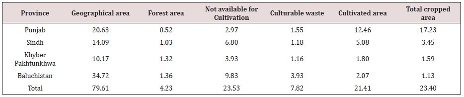
The province wise land use is presented in Table 1. The total area of Pakistan is 79.61 million hectares (mha) with 23.40 mha cropped area. The current cultivated area is concentrated in Punjab province with 12.46 mha, which is ~50 % of the total cropped area of Pakistan followed by Sindh Province at ~8 % of country’s cropped area. However, there is 7.82 mha culturable waste area that is largely concentrated in least developed provinces of Khyber Pakhtunkhwa (KP) and Baluchistan, which can be brought under cultivation to enhance food security. The province wise culturable waste areas are 12%, 23%, 64% and 190% of current cultivated lands in Punjab, Sindh, KP and Baluchistan respectively. Therefore, the agro based economies of KP and Baluchistan has greater potential for improvement by cultivating their culturable waste lands.
Table 1: Land use in Pakistan.
lupinepublishers-openaccess-journal-environmental-soil-sciences
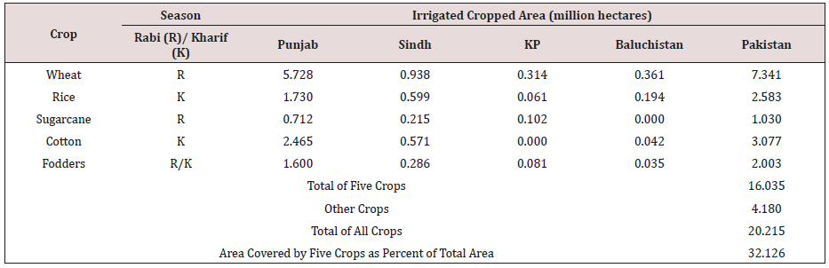
The irrigated cropped area in Pakistan is around 18.84 mha (Table 2) according to Agriculture Statistics of Pakistan 2006-07. This includes: wheat 7.34 mha (36.3 % of total); rice 2.58 mha (12.8 % of total); cotton 3.01 mha (15.2 % of total); sugarcane 1.03 mha (5.1 % of total); and fodders 2.00 mha (9.9 % of total). These five crops cover 16.03 mha of total irrigated area in Pakistan, which is 79.32% of the total irrigated area. Therefore, improving water productivity of these five major crops would have major impacts on productivity of irrigated agriculture in Pakistan. Other crops cover 4.17 mha; which constitute around 21.68 % of total irrigated area in Pakistan. The climate change induced floods and droughts significantly impact on crop production, especially during Kharif (summer) season, from both irrigated and rain-fed areas of Pakistan. The current land use methods tend to exacerbate the soil and water degradation and reduce land productivity potential. Similarly damage to standing crops due to lodging caused by heavy winds, water logging and salinity and frequent water stresses at crop critical growth stages causes production losses. Therefore, the traditional farming techniques need to be modified to control crop damage due to climate change induced threats, which is essential for sustainable agriculture in the country.
Table 2: Irrigated cropped area of major crops in Pakistan.
lupinepublishers-openaccess-journal-environmental-soil-sciences

Temporal Water Availability During Rabi and Kharif Seasons In Pakistan

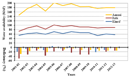
Temporal surface water availability and deficiency during rabi (winter) and kharif (summer) seasons in Pakistan is shown in Figure 1. Temporal changes indicated up to 23% increase and down to 16% decrease in total annual available surface water since 2001 until 2007. However, the variability in total annual available surface water diminished below 5% since 2009 onward. Interestingly a major flood occurred during 2010, but data show insignificant impact on the total water availability (Figure 1). Thus, climate change cannot be judged from the total water availability. However, the frequency, intensity and distribution of rainfall are important parameters to be considered. Similarly, the average deficiency remained around 6.4% during Kharif (summer season) and around 24% during Rabi (winter season) with an average annual water deficiency of around 13% during the last twelve years.
Figure 1: Temporal surface water availability and deficiency during rabi (winter) and kharif (summer) seasons in Pakistan.
lupinepublishers-openaccess-journal-environmental-soil-sciences

Increased Use of Groundwater in Pakistan

Canal water fluctuation and unreliability due to climate change has increased farming community dependence on groundwater during the last decade. The changing trend of water availability is presented in Table 3. The statistics of canal and tube well irrigated area in provinces from 1993-94 to 2010-2011 (Table 3) indicate a decrease of 19% and 26 % in canal irrigated areas and an increase of 26 % and 157% in tube well irrigated areas in Punjab and Sindh provinces respectively. The overall tendency from 1993-94 to 2010- 11 indicated a decrease of 17.5 % in the canal irrigated areas and an increase of 33.5 % in groundwater irrigated areas in Pakistan. The overexploitation of groundwater is coupled with saline water up-coning and disposing of deep brackish groundwater into the soil surface thus causing fertile lands barren in Pakistan. It is therefore essential to reduce groundwater usage by utilizing surface water more efficiently for fulfilling irrigation demands of larger areas. Thus, the traditional irrigation methods need to be modified to more efficient methods to reduce groundwater usage.
Table 3: Temporal change in irrigated area under surface and groundwater in Pakistan.

lupinepublishers-openaccess-journal-environmental-soil-sciences

Climate Resilient Interventions for Improving Food Security in HKH Region

The existing land use, crops, water availability and usage statistics clearly indicate that the traditional farming techniques are not capable to cope with the climate change induced risks. It is therefore essential to adopt suitable climate change risks mitigation interventions for improving food security in HKH region. Few of these interventions/technologies successfully adopted in irrigated leveled lands downstream of HKH are summarized below:

Furrow Bed (Raised Bed) Irrigation Systems

Furrow bed irrigation system is one of the commonly used form of surface irrigation throughout the world (Figure 2) and is generally considered a more water-efficient system compared with the traditional flat basin because of (i) the speed with which water is conveyed to the low end of a field [7]; and (ii) the relatively small proportion of the soil surface is in contact with the flowing water during irrigation than the basin [8]. Furrow bed irrigation system is important in the current climate change scenario of
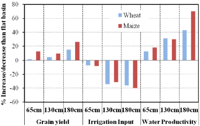
Figure 2: Advantages of furrow bed over flat basin [11].
lupinepublishers-openaccess-journal-environmental-soil-sciences
Pakistan agriculture in particular and Himalaya region in general due to the following reasons:
a) Furrow bed can save up to 50% irrigation water in comparison with traditional flat basin thus can reduce impact of limited water availability on crops in drought prone areas;
b) Furrows can quickly drain excess floodwater thus can reduce crop damage in flood prone areas;
c) Furrow beds reduce crops lodging by providing safe path and exit to speedy wind currents and greater reinforcement due to strong roots and soil grip;
d) Furrow beds laid perpendicular to slope can increase soil infiltration and ground water recharge by delaying runoff down slope and providing larger surface water storage capacity in furrows;
e) Conservation agricultural practices including minimum tillage, ground cover/mulching etc can be conveniently adopted on furrow beds which reduce soil erosion and soil and water degradation;
f) Furrow beds support mechanized farming thus can increase crop production and can be adapted to technological progress.
The Climate, Energy and Water Research Institute (CEWRI) of Pakistan Agricultural Research Council (PARC) has played a pioneer role in evaluation of furrow beds in Pakistan. Research conducted has shown that furrow beds is effective in improving yield of wheat by 20%, cotton 19%, Maize 58%, rice 26% compared with flat basin or ridge irrigation systems [9,10]. Similarly, crop yield per unit area increases by increasing the bed width. For instance, crop yield of maize showed up to 15% increase while wheat crop showed 26% increase on 180 cm bed size compared with flat basin [11], which was the largest increase noted when compared with other bed sizes given in Figure 2. Water saving of up to 50% in wheat, 30% in maize, 40% in cotton, 29% in rice were reported by N Ahmad et al. [9], Gill et al. [10], Hassan et al. [12]. Increase in water saving by increasing bed has been demonstrated in Figure 2 [9], which shows up to 40% and 36% increase in water saving by adopting 180cm bed size for maize and wheat crops respectively. Furrow bed increase crop yield and reduce irrigation application thus consequently crop water productivity is increased. For instance, an increase in water productivity of up to 70% in maize and up to 43% in wheat were reported by Hassan et al. [12] and Akbar et al. [13]. Impact of bed width on water productivity is illustrated in Figure 2, which shows up to 70% and 43% increase in water productivity for maize and wheat crops respectively compared with flat basin [13].
The CEWRI-PARC in collaboration with Australian Centre for International Agricultural Research (ACIAR) played a pioneer role in adopting furrow bed irrigation system in Maize wheat system of Pakistan. Conservation agricultural practices involving minimum soil disturbance were introduced in the form of permanent raised bed (PRB) farming system. Different bed width and furrow sizes were evaluated and demonstrated at farmer fields. Raised bed machinery imported from Australia was indigenously produced. The furrow bed farming system was disseminated by giving incentive to the farmers in the form of giving subsidies in purchasing raised bed machinery, training and demonstrations in the country. Although there are still issues in the machinery, especially for adopting PRB farming system, but the furrow bed system has been adopted widely for maize, cotton, sugar beat and vegetables crops throughout the country.

Sprinkler Irrigation Systems

In sprinkle irrigation method water is spayed into the air at 70-700 kpa (10-100 psi) pressure that fall on the ground or crop canopy like rainfall [14]. Using sprinkle irrigation system, the crop requirement can be accurately fulfilled through a combination of measures involving careful selection of sprinkle nozzle size, operating pressure and sprinkle spacing, thus adjusting sprinkle application rate to suit the soil infiltration rate. Sprinkle irrigation systems have increased importance for HKH region in the current climate change scenario due to the following reasons:
a) Use limited available water more efficiently as the application efficiency of a well-designed sprinkle system can vary from 60-80% thus can increase crop production and irrigated lands;
b) No land leveling required thus reduce operation cost and protect environment by avoiding cutting and filling of cultivated lands;
c) Irrigation of steep and rolling topography without producing runoff or erosion;
d) Greater potential to increase agricultural production by bringing extra undulating and sloppy HKH terrain under irrigation;
e) Light shower can avoid crop damage due to temperature extremes year around;
f) Timely irrigation of few centimeter using sprinkler irrigation system can double crop yield at critical crop growth stages, especially during wheat germination in HKH region;
g) The pre-sowing irrigation (Rouni) can be applied with sprinkler system for timely planting of crops.
All these factors increase sprinkle irrigation system suitability to the HKH region in the current climate change scenario. However, there are few drawbacks. For instance, these systems are affected by wind and, depending on the size of droplets and the spray trajectory, uniform distribution may be limited. Sprinkle systems have high initial costs and maintenance requirements. They also use high operating pressures, which has large energy requirement. The cost of portable and semi portable system is less but difficult to operate due to movement of laterals. The CEWRI-PARC in collaboration with local industries developed a complete range of rain gun sprinkler irrigation systems, including diesel, electric and PTO-driven pumping systems, couplers, other fittings and joints. To keep the systems portable, the pumping unit along with power unit (diesel engine, electric motor and solar panels) was mounted on a trolley. These systems have been used in the Khanpur Dam area where the rain gun sprinkler irrigation system is being used for establishment of orchards, efficient irrigation of fruits and vegetables, washing of Lychi and citrus, and for cooling and frost control in orchards. Initial investment requirements and unreliable electricity are restricting wider adoption of this technology.
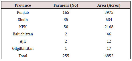
These rain gun sprinkler irrigation systems have been installed in various parts of Pakistan for demonstration and introduction of the technology. In rain fed areas, these systems are being used for supplemental and life-saving irrigations to fruits, vegetables and field crops. The research conducted by CEWRI-PARC resulted in local fabrication of Poly Ethylene (PE) based irrigation system components, sprinklers and high-pressure pumps. Based on research findings and success of pilot-scale installations, the Government of Pakistan launched a National Program entitled “Water Conservation and Productivity Enhancement through High Efficiency Irrigation Systems in Pakistan” during 2007-12. Drip and sprinkler irrigation systems were installed on an area of 6852 acres in all provinces (PARC 2010). The major area was in Punjab and followed by KP. There were 255 farmers benefitted from the project. There were 80 % sprinkler irrigation systems and 20 % were drip system during the period (Table 4).
Table 4: Drip and sprinkler irrigation systems in provinces, installed under the national project (from 2007-2012).
lupinepublishers-openaccess-journal-environmental-soil-sciences

Drip Irrigation Systems

Drip irrigation system applies water close to each plant and the application uniformity depends on the uniformity of discharge from the emitters [14]. It generally comprises of a pumping station, control head, main and sub main lines, lateral lines, emitters, valves and fittings. The drip irrigation system has special agronomical, agro technical and economic advantages that make it a suitable option of irrigation in the HKH and adjoining region. These advantages are as under:
a) Drip irrigation can conveniently and efficiently supply water directly to the individual crop rows or plants, thus can effectively utilize small continuous streams of water in the HKH region;
b) It reduces water requirement by saving up to 50% irrigation water to a young orchard as compared to sprinkle or surface irrigation methods thus can enhance community resilience to drought;
c) It requires less labor, as a well-regulated system can effectively utilize a continuous stream of water, a norm in HKH region, with less farmer supervision thus can increase production;
d) It discourages weeds growth and offers greater control over fertilizer placement and timing thus can save farmer resources;
e) Drip irrigation can be designed for any topography even if the area is rocky with steep slopes and plants are with irregular spacing, which increase its importance for HKH region.
Drip irrigation systems have shown yield gains of up to 100%, water savings of up to 40–80%, and associated fertilizer, pesticide, and labor savings over conventional irrigation systems [15]. The low rate of water application reduces deep percolation losses. The systems have lower energy requirements than sprinkler systems because of lower operating pressure requirement. The water application uniformity of locally developed drip irrigation system was above 85 % [16]. Evaluation of drip systems at CEWRIPARC showed lowest coefficient of variation of locally developed microtube emitters [17] with application uniformity above 85 per cent [16]. This shows that trickle irrigation systems have potential to use scarce water resource more efficiently if designed properly. The evaluations by Ahmad MM et al. [18] indicated that drip system with micro tube emitters can be operated at low pressure head (3.5 m) with an insignificant loss in uniformity as compared to operating at high pressure head (10 m), which can save energy cost, as given in Table 5. This low head drip system is being used for small scale vegetable production in Pakistan.
Table 5: Microtube emitter discharge and water application uniformity at various pressure heads and distances Ahmad et al. [9].

lupinepublishers-openaccess-journal-environmental-soil-sciences
These research outcomes are currently being disseminated through training and demonstration in provinces. The provincial governments are adopting drip/sprinkler systems evidenced through various programs, indicating government commitment for accelerating drip/sprinkler system adoption. By successful adoption of these technologies, more water can be saved or efficiently used along with an increase in yield. The saved water will automatically reduce over exploitation of groundwater and consequently mitigating the secondary salinity by improving overall water use efficiency of the irrigation system. This shows that the system has potential to use scarce water resource more efficiently if designed properly.

Conclusion and Recommendations

a) Lack of adoption of climate change resilient practices in the hill ecology of HKH region is negatively affecting their food security and also have negative implications for the irrigated agriculture downstream in adjoining countries;
b) The 51% area of Pakistan falls in HKH region, thus was considered as a representative case example for analyzing their agricultural production system, growing food security and climate change issues and promising climate resilient interventions mainly adopted in downstream leveled irrigated areas of HKH region;
c) Furrow bed, sprinkler and drip irrigation systems has been shown efficient irrigation methods with multiple advantages thus can be instrumental for improving community resilience to climate change by conserving the declining and uncertain available water resources in the hill ecology of HKH region;

d) However, adoption of these technologies is equally important for improving climate change resilience, food security and livelihood of the hill ecology of HKH region.

For more Lupine Publishers Open Access Journals Please visit our website:
For more Open Access Environment Journal articles Please Click Here:
To Know More About Open Access Publishers Please Click on Lupine Publishers


Follow on Twitter   :  https://twitter.com/lupine_online

Monday, 2 December 2019

Lupine Publishers | Spatial Analysis of Data on the Basis of the Digital Model of Relief and Locality (Example of Shemakha, Akhsu and Ismayilli Districts)

Abstract

The article examines the issues of studying the degree of susceptibility of sloping lands in Azerbaijan in the example of specific administrative territorial units, flat areas with a slope of up to 6% (about 3.50) are concentrated in Akhsu district 71%, and in Shemakha almost 49%. The steepest slopes are observed in the Ismaili region, where almost 26% of the territory has a slope of 10-18%, 30% of its area slope is 18%.


Introduction

Figure 1 Spatial analysis includes operations performed on geographic data using available methods and techniques in GIS software, with a view to describing the relationships between elements of the geographical environment. The analysis can be carried out on the data, both in the vector and raster systems, and touch the geometry and attributes of the vector data [1-8].
Figure 1.
lupinepublishers-openaccess-journal-environmental-soil-sciences

Search for Information in the Database

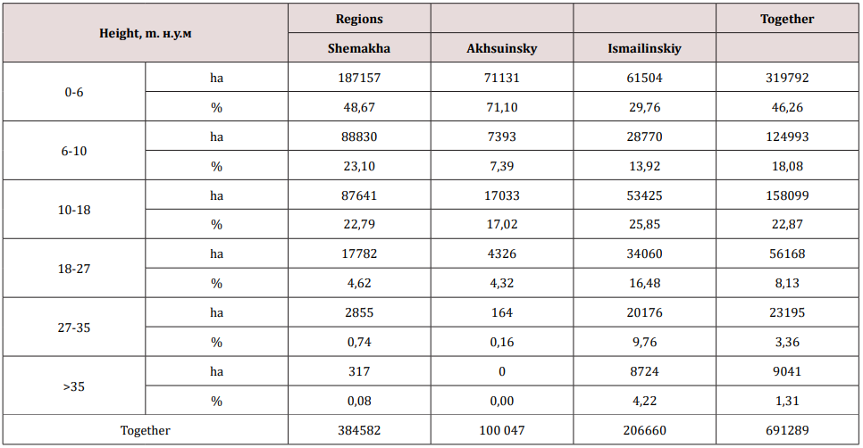
The main operation that can be performed based on the GIS database is information retrieval. This database has a relational nature and therefore, the object designation provokes the selection of the corresponding records from the corresponding attribute table, and vice versa. The first thematic layer in the database was the Digital Elevation Model in raster format. On its basis, as a result of the transformations and calculations, information on the height of the nos. and the slope of the terrain on the territory of Azerbaijan selected for analysis, which includes three regions: Shemakha, Akhsu and Ismayilli.

Vertical Position Factor

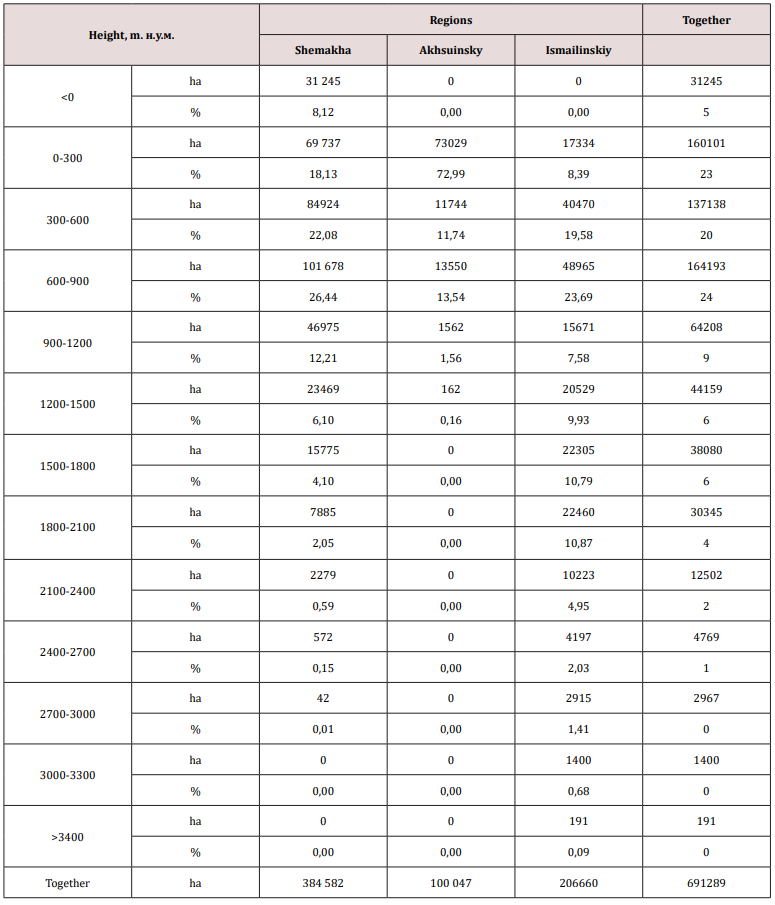
The major part of the study area is in the following ranges of heights: 1) from 0 to 300 mas-23.16%, from 300 to 600 m-19.84% and 3) 600-900 m-23, 75% of the total area. Above 900 m and up to 3400 m above sea level, about 30% of its area is located (Table 1). Of the administrative units belonging to the study area, the most highly allocated land Ismaili region. In this area 90: it is at an altitude of more than 300 meters above sea level, and sometimes the altitude is even higher than 3400 m. In Akhsu region about 73% of the earth is at an altitude up to the sea level. Shemakha district is an intermediate region, its largest area is at an altitude of 900 m above sea level-about 75%. In this area there is also a territory located below sea level-31244.66 hectares [8-18].

Classes of Slope

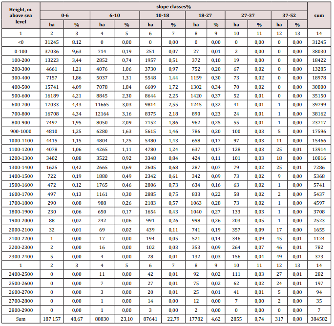
In the analyzed territory, the largest area is occupied by areas with a slope of up to 6-46%. Significant areas are also in the intervals from 6 to 10% -18% and from 18% to almost 23% of the total area (Table 2). Against the backdrop of administrative-territorial units, gently sloping areas with a slope of up to 6% (about 3.50) are concentrated in the Akhsu district 71%, and in Shemakha almost 49%. The steepest slopes are observed in the Ismaili region, where almost 26% of the territory has a slope of 10-18%, 30% of its area slope is 18%.
Table 1: The distribution of the study area (ha and%) over the altitude intervals.
lupinepublishers-openaccess-journal-environmental-soil-sciences
Table 2: The distribution of the study area (ha and%) over the slopes of the terrain.
lupinepublishers-openaccess-journal-environmental-soil-sciences

Classes of the Slope of the Terrain, Depending on the Altitude Intervals

Table 3: The distribution of the territory of the Shemakha district according to the grades of the terrain according to the altitude intervals.
lupinepublishers-openaccess-journal-environmental-soil-sciences
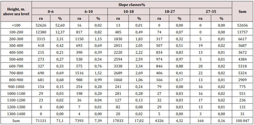
Table 4: Distribution of the territory of the Akhsu region according to the grade of the terrain depending on the altitude interval.
lupinepublishers-openaccess-journal-environmental-soil-sciences
Table 5: The distribution of the territory of the Isma yilli region according to the grades of the terrain according to the altitude intervals.
lupinepublishers-openaccess-journal-environmental-soil-sciences
Tables 3-5 contain data that allow analyzing the distribution of the slope of the terrain along altitude intervals. This distribution was prepared for all administrative units of the area under consideration. In the Shemakha region, a clear dependence is shown, an increase in the slope, along with an increase in altitude above sea level. Up to a height of 1200 m there are lands with a slight slope-up to 6% (3.50). They occupy 49% of the area. Territories here with a slope of 6-10% and 10-18% are located at an altitude of 400-1700 m. M.u.m. about 23% of the area’s area. Areas with a slope of more than 18% make up more than 5% of the total area and are located in the highlands. In the Aksuinsky area, the terrain with an insignificant slope of up to 6% (3.50) prevails and they are located mainly at an altitude of 300 m above sea level - this is 71% of the total area. Areas with a slope of more than 6% are located at altitudes from 300 to 1400 m above sea level - about 29%. Clearly marked (17% of the total area) of land with a slope of 10-18% (6- 100) (Table 4).

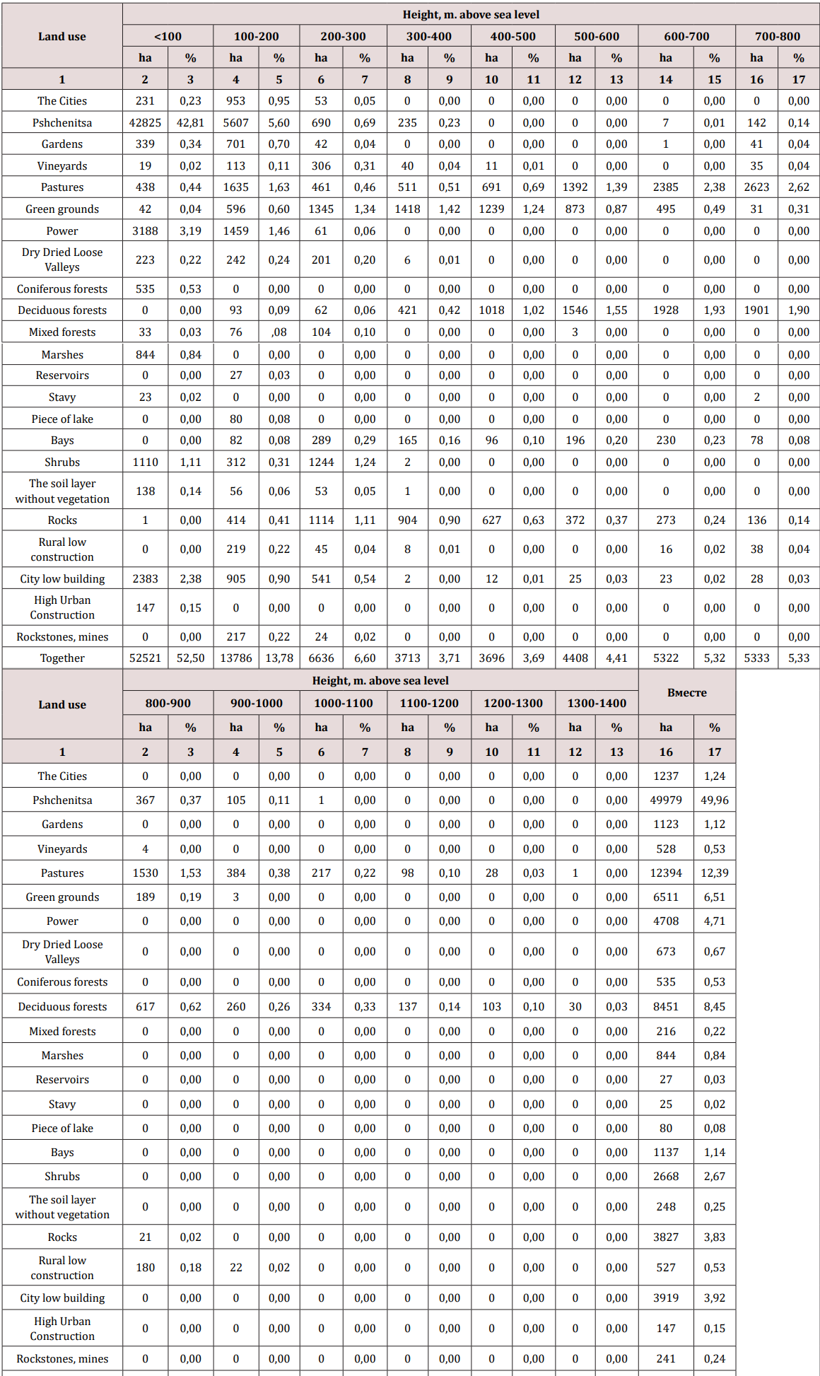
In the Ismayilli region, most of the territory with a slope of &alt;6 to 10% is located at an altitude of 300 to 900 m above sea level. Areas with a slope of 10 to 37% occur at an altitude of 3000 meters above sea level. Locations with a slope of more than 37%% are located at the highest altitude but make up only 4% of the total area of the area. The second, from the thematic layers created in the database, is the land use of the study area. Due to the availability of cartographic materials, it was considered exclusively for the territory of the Akhsu district.

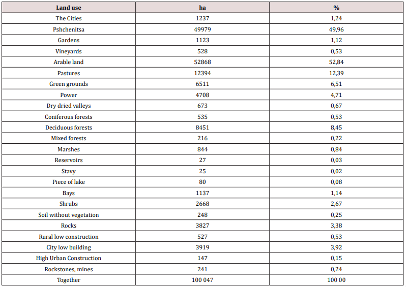
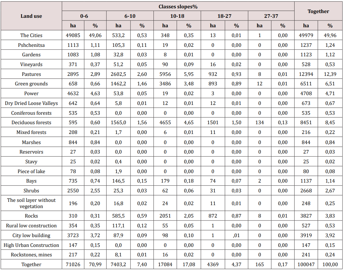
Analysis of the structure of land use in the Akhsu district showed that it is purely agricultural. The area is dominated by arable land, which makes up about 50% and tilled areas, which include pastures, meadows and degrees - more than 23% of the total area. Agricultural lands are supplemented with vegetable gardens, orchards and vineyards, occupying 3% of the area. There are few forests and shrubs, in general, about 12%. There are also areas completely devoid of vegetation in the Akhsu district, about 4% of them. A small part is occupied by water reservoirs, wetlands and urban and rural areas, amounting to 6.9% of the total area (Tables 6-8) provide information on the distribution of land use patterns over altitudinal intervals and grades of terrain slopes. Most agricultural land is located at a height of up to 400 m above sea level. Only pastures are located up to an altitude of 1400 meters above sea level. forest territories are in all altitude intervals. The remaining forms of land use are located at lower altitudes (Table 7). Considering the slope of the slopes, most of the territories are in the gradient class 0-6% - almost 71%. Only pastures, green lands, as well as deciduous forests, are located on slopes with a higher slope (Table 8).
Table 6: Land use in Ahsuinsky district.
lupinepublishers-openaccess-journal-environmental-soil-sciences
Table 7: Land use by altitude intervals.
lupinepublishers-openaccess-journal-environmental-soil-sciences
Table 8: Land use according to grades of the slope of the terrain.
lupinepublishers-openaccess-journal-environmental-soil-sciences


For more Lupine Publishers Open Access Journals Please visit our website:
For more Open Access Environment Journal articles Please Click Here:
To Know More About Open Access Publishers Please Click on Lupine Publishers

Friday, 8 November 2019

Lupine Publishers | Review of the Effect of Climatic Conditions to the Development of Erosion Process in Soils of Azerbaijan


Lupine Publishers- Environmental and Soil Science Journal


Abstract

The Researchers proved that the process of soil erosion is also closely linked to climatic conditions of the region. Therefore, depending on the climatic conditions of the erosive processes are different in both forms of its manifestation, and the quantitative indicators of development. For example, in the north-eastern part of the Greater Caucasus Highlands powerful deposition of snow cover, high intensity of spring melting of snow and summer rain water rainfalls the calling intensive lavages and size of its development areas. But here, against a backdrop of high air temperatures during the growing season, pronounced wind regime and extremely low relative humidity of the air is wind erosion. Climate also affects the surface configuration. Humid areas where vegetation cover protects the soil from severe manifestations of water and wind erosion, characterized by soft, rounded slopes.

Introduction

Soil erosion is an ongoing process, which consists in moving soil mass from one place to another, under the influence of water, wind and gravity [1]. Among the numerous classifications, organize my erosive phenomenon, the most important is the separation of erosion: natural (caused by forces of nature) and accelerated (caused by human activities). Erosion processes caused by forces of nature (wind, water and gravity erosion), the largest scale in a glacial period when the vegetation was negligible. The emergence of higher (herbaceous and woody) plants heavily restricted and even helped to overcome the action of erosion processes, accelerate soil formation processes and soil formation [1,3]. Human activities (agriculture (agronomy) erosion) is the main factor which contributes to development and an increase in the intensity of erosion processes, collapsing the Earth’s mainland surface, which led to the significant in terms of size, soil degradation, reducing, and even destruction of its productive capacity, compared with natural conditions [2].
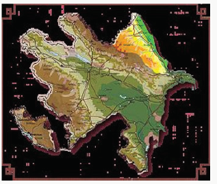
Figure 1: Map of erosion risk soils of Azerbaijan.
lupinepublishers-openaccess-journal-environmental-soil-sciences


Progress in the Study and Discussion of Materials

(Economic), from a practical point of view stands out-a potential erosion described as erosion risk and actual (current) erosion, described as erosive damage in mostly size floating soil masses (in mm thickness or t/ha or km2). Along with that, in areas with dry climates where the water flows very fast and where the wind taking sand particles and working them as cutter, erases the surface and sweeps weathering products typical of sharply defined overskirt. When examining the erosion problem is extremely important to identify leading factors and establish their relevance to the erosive process. Such determinant nature of erosion is primarily precipitation, then wind regime [3]. Development intensity of erosion processes is defined not only in terms of average annual precipitation in the area, but also to a large extent, their intensity. If most of the annual rainfall mean weak or moderate falling rain, moisture is absorbed into the soil without runoff and erosion, favorable conditions for snow water absorption of small runoff and erosion of underdevelopment is created and, if large part of rainfall on soil nonfreezing or motion enough snow limits the freezing it [2,5]. With little snow cover and the same deep frost heave soil warm spring rains can cause increased melting of snow, strong stock and sharply expressed by erosion. Of equal importance is the distribution of rainfall in time. Particularly unfavorable for erosion control is a long, albeit moderate intensity falling rain and extremely intense intermittent showers. The first type of falling rain soil, sated after some time in the future moisture absorbs it very slowly, with the result that the run off and surface erosion are amplified When intense. showers water enters the soil surface so fast that even structural, drained soil doesn’t absorb increases it, resulting in the formation of enhanced runoff and erosion. Especially destructive processes of storm runoff and washing, where vegetation, slopes, even from much permeability of soils do not protect [2,3]. Pounding raindrops in this case crush soil (semi arid and arid regions) aggregates and form on the soil surface rather ton, razzhizhennuju mud, which clogs the pores of the infiltration process and drastically weakens the absorption of moisture. This in turn reinforces the excessively drain and erosion even on light soils.
On the surface of the chilled soil flushing processes are absent. But the freezing and thawing of the soil the timephased cause slipping its particles and even washed away down the slope.These processes of sliding and soil flushing occur particularly intensively in cases where spring temperatures accompanied by warm rains. Rains causing it to thawing the soil, often wash off all its surface layer.The erosion caused by rain and heavy waters, exposure conditions affected to a much lesser extent. The wind is also a very important and active agent of erosion, which is widely published in the form of wind erosion, exclusively inherent in semi-arid and arid regions, although only to the extent that this factor is the most dramatic [3,5]. In essence, the same uncoated soil surface depends to a greater or lesser degree on the distorting effect of wind flowing all over the world, even in wet areas. Under the influence of a blatant and smoothening (winding) wind vortex, the soil particles rise into the air and larger moving rolling elements either in jumps and boundaries and precipitate to form deposits in the form of spit, ridges or dunes, the risk of wind erosion especially increases the dryness of the weather in spring [2,6].

For more Lupine Publishers Open Access Journals Please visit our website:
For more Open Access Environment Journal articles Please Click Here:
To Know More About Open Access Publishers Please Click on Lupine Publishers

Follow on Twitter   :  https://twitter.com/lupine_online

Wednesday, 30 October 2019

Lupine Publishers-Environmental Issues and Disaster Management


Lupine Publishers- Environmental and Soil Science Journal


What is Environment and Why it is Important?


This is a vast subject encompassing the entire system of human activities. Simply, environment is defined as: all forms that surrounds us life forms [humans, animals, birds] & non-life forms moving [air, water] & non-moving [mountains, forests]. Human settlement interacts with the environment in a complex fashion involving many different scales. The survival of all life forms on the Earth is a function of healthy and balanced growth of environment in space and time. The new economic order must make it mandatory to protect the environment to have a balanced growth at present and in future. We should not think forests, trees, and croplands as carbon sinks, but we must look at them that provide clean air for our survival. We take oxygen from the surroundings and give out carbon dioxide; and at the same time plants take carbon dioxide and release oxygen. These two groups of ecosystems complement each other. Drastic changes in either of them leads to unsustainable environment. Today, population is the greatest problem facing the country. In the past, the nature used to keep the balance through natural disasters and epidemics. Now, with the advent of modern medicine we are in control of epidemics and with the advancements in science and technology we are in a position to reduce the impacts of natural disasters but at the same time increased the diseases and disease rate. Human societies’ impact on environment is a function of population growth, more particularly in urban areas with around 30% concentration which may reach 60% by 2050, their consumption pattern and their innovative technologies-based lifestyles. We consume resources from healthy ecosystems and make it unhealthy ecosystem over time.
Just before Paris Climate meet in 2015, Pope Francis released a provocative encyclical on the environment-Laudato Si. Again, later he emphasized that destroying the environment was a sin. He further noted that humans were turning the planet into wasteland of debris, desolation and filth, and called for urgent action. Pope Francis further emphasized that, “We must not be indifferent to the loss of biodiversity and destruction of ecosystems, often caused by our irresponsible and selfish behavior”. He called for consumers to modify their modern lifestyles by reducing waste, planting trees, etc. The same was emphasized by UN & US President just before Paris meet. But this was not reflected in the Paris Agreement Document. A report of UNDP [United Nations Environment Program] warns about the rising water pollution in three continents, namely Asia, Africa and Latin America, placing hundreds of millions of people at risk of contracting life-threatening diseases and putting aquatic flora and fauna under extinction threat. It observed that, “The increasing amount of wastewater being dumped into our surface waters is deeply troubling.

What is Disaster and how it Impacts Environment?

The major causes for unsustainable environmental growth in the modern world are the “disasters”. A disaster is a serious disruption of the functioning of a community or a society involving widespread human, material, economic or environmental loss and impacts, which exceeds the ability of the affected community or society to cope using its own resources. We are encountering with three types of hazards, namely natural, manmade and socio-natural hazards. The natural disasters are beyond human control and thus we need to adapt to them. The manmade disasters are though in the hands of man they rarely follow the precautionary principle - prevention is better than cure policy. Here human greed and poor governance play the pivotal role along with poor civic sense among poor to elite.

Natural hazards

Are hazards which are caused because of natural phenomena. They are of meteorological, geological or even biological origin. Examples of natural hazards are cyclones, tsunamis, earthquakes and volcanic eruptions which are exclusively of natural origin.

Manmade hazards

Are hazards which are due to human negligence. Manmade hazards are associated with industries or energy generation facilities and include explosions, leakage of toxic waste, pollution, dam failure, wars or civil strife, etc. Now a day modern festival also comes under this group. The list of hazards is very long. Many occur frequently while others take place occasionally.

Socio-natural hazards

Landslides, floods, drought, fires are socio-natural hazards since their causes are both natural and manmade. For example, flooding may be caused because of heavy rains, landslide or blocking of drains with human waste are human induced. However, the rapid growth of the world’s population and its increased concentration often in hazardous environments has escalated both the frequency and severity of disasters. With the tropical climate and unstable land forms, coupled with deforestation, unplanned growth proliferation, non-engineered constructions which make the disaster-prone areas more vulnerable, tardy communication, and poor or no budgetary allocation for disaster prevention, developing countries suffer more or less chronically from natural disasters. Asia tops the list of casualties caused by natural hazards.

Nature

Is being destroyed by both natural disasters such as cyclonic activity, earthquakes, volcanic activity, tsunamis, etc.; and activities to meet human greed such as wars, oil-gas-water extraction, physical destruction of ecologically sensitive zones and destruction of natural water flow systems, violation of acts or laws, etc. are often attributed to global warming. The flood disasters in Hyderabad in September 2000; Uttarakhand in June 2013; Jammu and Kashmir/ Srinagar in September 2014; November-December 2015 in Chennai & Nellore; August 2018 in Mumbai; etc. are the manifestations of human greed. Now governments are wrongly putting the blame on global warming. Indian Institutions are making even Prime Minister to make false statements like “Chennai floods are associated with the Global Warming”. We must realize the fact that “ignorance is terrible, but exaggeration is dangerous”. A classic example of state disaster is Kerala August 2018 floods. To tackle the problem in the right way we need the cause of the problem in the correct way. The impacts of manmade disasters have been increasing with the time.

What is the Impact of Pollution on Environment?

Access to quality water and air are essential for human health and human development. Both are at risk if we fail to stop the pollution. Stan Cox’s “Sick Planet: Corporate Food and Medicine”, argues that corporate food and medicine industries are destroying environments and ruining living conditions across the world. Unplanned urbanization, population explosion, agriculture and uncontrolled sewage discharge in to rivers and lakes/tanks are primary reason behind the rise in surface water pollution. We are using groundwater indiscriminately, but we are not taking any action on recharging the groundwater and thus causing water pollution. The surface polluted water also polluting groundwater. Industries, mining, transport, etc. have been the major contributors of pollution. Civilization developed on the banks of the rivers throughout the world, as water was the basic necessity for all living beings. In the last two centuries, with the industrialization primarily around urban centers the rural population started migrating to urban centers for greener pastures. All these in urban areas and modern agriculture practices in rural areas introduced the evil pollution. Thus, directly and indirectly affected the environment and living organisms on the Earth. Children and adults today carry an estimated 300 or more chemical residues that were not present in their grandparent’s body. These chemicals accumulate in the body with the time and are passed on to the next generation often at high concentrations. Water borne diseases caused by intake of chemicals and contaminated water affecting around 3.4 million people globally.

We rarely look at precautionary principle; instead of prevention measures, we try controlling measures with which we rarely achieve the stated goal. Also, with isolated control measures, the scenario will not change. Take for example: will the Supreme Court order really improve the industrial pollution? The court needs to look into ground realities such as excess production and zero pollution. Without that, there will not be any improvement in reducing the pollution levels. Water is a natural resource, fundamental to life, livelihood, food security and sustainable development; it is also s scarce resource. India has more than 17.11% of the world’s population but has only 4.6% of world’s water resources with 2.3% of world’s land area. Precipitation and snow melt provide the fresh water; though they are renewable, they are highly variable with space and time; climate change plays vital role in the year to year water availability over different parts of India. India crossed 130 crore population and wasting around 40-50% of food produced – it is around 30% for the world as reported by FAO and the resources used to produce that is also simultaneously wasted. This is basically because of unplanned agriculture driven by technology that looks at profit than over the environment. Modern agriculture is causing air, water, soil and food pollution. We look at production growth, but we rarely look at the impact on environment by such technologies, more particularly on water resources and health of life forms. Though the industry uses very little, when the pollutants generated by industries released in to potable water, it changes potable water in to polluted water. This very rarely we account as the water used by industry.

How do We Achieve the Disaster Risk Reduction?

Preparedness

It is a protective process that embraces measures which enable governments, communities and individuals to respond rapidly to disaster situations to cope with them effectively. It also includes the formulation of viable emergency plans, the development of warning systems, the maintenance of inventories and the training of personnel. It may also embrace search and rescue measures as well as evacuation plans for areas that may be at risk from a recurring disaster. Preparedness therefore encompasses those measures taken before a disaster event which are aimed at minimizing loss of life, disruption of critical services, and damage when the disaster occurs.

Mitigation

It embraces measures taken to reduce both the effect of the hazard and the vulnerable conditions to it in order to reduce the scale of a future disaster. Therefore, mitigation activities can be focused on the hazard itself or the elements exposed to the threat. Examples of mitigation measures which are hazard specific include water management in drought prone areas, relocating people away from the hazard prone areas and by strengthening structures to reduce damage when a hazard occurs. In addition to these physical measures, mitigation should also aim at reducing the economic and social vulnerabilities of potential disasters. However, with poor civic sense among poor to elite along with poor governance in some cases this is rarely achieved. Examples under this are the flood disasters mentioned earlier pages.

Industrial Pollution Related Disasters

In the case of pollution, some are point sources and some others are non-point source. Industrial pollution is point source pollution. There are rules and regulations to control the pollution through Water Act of 1974, Air Act of 1981, and Environmental Act of 1986, EIA Notification 2006, etc.; and for which pollution control boards were established to regulate them. However, the system is weak. A classic example to this is the Bhopal gas tragedy. This disaster would have been averted if the government departments followed the stipulated norms. Instead, they allowed residential houses all around the factory, which has been resulted the great tragedy. Another example is urban water [surface & groundwater] pollution that drastically reduced the potable water availability.

Agricultural pollution related disaster

Agricultural pollution is non-point source pollution and thus there are no rules and regulations. The only solution is change of technology. Though some farmers are attempting in this direction, the governments are not showing much interest in this direction. Gulf of Mexico turned in to a dead zone spreading over thousands of square kilometers with runoff that contains residues of chemical fertilizers & sprays from agricultural farms carried through Mississippi River in USA.

For more Lupine Publishers Open Access Journals Please visit our website:
For more Open Access Environment Journal articles Please Click Here:
To Know More About Open Access Publishers Please Click on Lupine Publishers

Follow on Twitter   :  https://twitter.com/lupine_online
Tuesday, 24 September 2019

Effect of Interaction Between Ag Nanoparticles and Salinity on Germination Stages of Lathyrus Sativus L.


Lupine Publishers- Environmental and Soil Science


Abstract

The aim of the study was to effect of interaction between Ag nanoparticles and salinity on Germination Stages of Lathyrus Sativus L. Treatments included in the study were viz. To 3 levels of salinity (0 as control, 8 and 16 dS/m NaCl), 8 and 16 dS/m and four levels of silver nanoparticles (0, 5, 10 and 15 ppm) on grass pea seed were tested. An experiment was conducted to evaluate the effects of silver nanoparticles (AgNPs), on the seed germination factors, root and shoot length (RL and SL) and proline content of grass pea Survival under Salinity Levels. Results showed a significant reduction in growth and development indices due to the salinity stress. The salt stress impaired the germination factors of grass pea seedlings. The application of Ag in combination improved the germination percentage, shoot and root length, seedling fresh weight and seedling dry weight and seedling dry contents of grass pea seedlings under stressed conditions. The results suggest that Ag nanoparticles enhancement may be important for osmotic adjustment in grass pea under salinity stress and application of Ag mitigated the adverse effect of salinity and toxic effects of salinity stress on grass pea seedlings.

Introduction

High salinity is a common abiotic stress factor that causes a significant reduction in growth. Germination and seedling growth are reduced in saline soils with varying responses for species and cultivars [1]. Soil saltiness may impact the germination of seeds either by causing an osmotic potential outside to the seed averting water uptake, or the poisonous effects of Na+ and Cl− ions on germinating seed [2]. Salt and osmotic stresses are responsible for both inhibition or delayed seed germination and seedling establishment [3]. The majority of our present-day crops are adversely affected by salinity stress [4]. NaCl causes extensive oxidative damage in different legumes, resulting in significant reduction of different growth parameters, seed nutritional quality, and nodulation [5,6]. To mitigate and repair damages triggered by oxidative stress, plants evolved a series of both enzymatic as well as a non-enzymatic antioxidant defense mechanism. Ascorbate and carotenoids are two important non-enzymatic defenses against salinity, whereas proline is the most debated osmoregulatory substances under stress [7].
Lathyrus Sativus L. (Grass pea) is an annual pulse crop belonging to the Fabaceae family and Vicieae tribe [8]. Grass pea has a long history in agriculture. The crop is an excellent fodder with its reliable yield and high protein content. This plant is also commonly grown for animal feed and as forage. The grass pea is endowed with many properties that combine to make it an attractive food crop in drought-stricken, rain-fed areas where soil quality is poor and extreme environmental conditions prevail [9]. Despite its tolerance to drought it is not affected by excessive rainfall and can be grown on land subject to flooding [10,11]. Compared to other legumes, it is also resistant to many insect pests [12-15]. Nanoparticles (NPs) are wide class of materials that include particulate substances, which have one dimension less than 100 nm at least [16]. The importance of these materials realized when researchers found that size can influence the physiochemical properties of a substance e.g. the optical properties [17]. NPs with different composition, size, and concentration, physical/ chemical properties have been reported to influence growth and development of various plant species with both positive and negative effects [18]. Silver nanoparticles have been implicated in agriculture for improving crops. There are many reports indicating that appropriate concentrations of AgNPs play an important role in plant growth [19,20]. The application of Nano silver during germination process may enhance germination traits, plant growth and resistance to salinity conditions in basil seedlings [21]. The use of Silver Nanoparticle on Fenugreek Seed Germination under Salinity Levels is a recent practice studied [22]. Nanomaterials have also been used for various fundamental and practical applications [23]. Although the potential of AgNPs in improving salinity resistance has been reported in several plant species [24,25], its role in the alleviation of salinity effect and related mechanisms is still unknown. Therefore, the main objective of this work was to study the effect of Silver Nanoparticles on salt tolerance in Lathyrus Sativus L.

Material and Methods

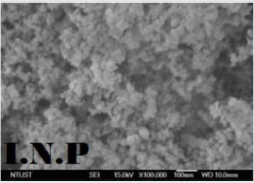
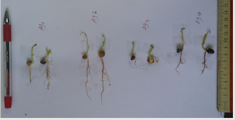
In order to investigate salinity stress on Lathyrus Sativus L. germination indices, an experiment was carried out in Iran from April to Juan 2017 at Ferdowsi University of Mashhad, to creation salinity, sodium chloride at the levels of 8 dS/m, 15 dS/m and 0 (as control), four levels of silver nanoparticles (0, 5, 10 and 15 ppm) on Grass pea were tested. The Ag NPs were obtained from US Research Nanomaterial’s, Inc. Transmission electron microscopy (ТЕМ) images of silver nanoparticles with diameters of 20 nm, shown in Figure 1. Seeds of Lathyrus Sativus L. where from seed bank of Research Center for Plant Sciences, Ferdowsi University of Mashhad. These all were washed with deionized water. Seeds were sterilized in a 5% sodium hypochlorite solution for 10 minutes [26], rinsed through with deionized water several times. Their germination was conducted on water porous paper support in Petri dishes (25 seed per dish) at the controlled temperature of 25 ± 1°C. After labeling the Petri dishes, seed were established between two Whatman No. 2 in Petri dishes. Silver nanoparticles in different concentration silver nanoparticles (0, 5, 10 and 15ppm) were prepared directly in deionized water and dispersed by ultrasonic vibration for one hour. Each concentration was prepared in three replicates. Every other day supply with 0.5 ml silver nanoparticles per every test plantlet was carried out for 21 days along with control. Germination counts were recorded at 2 days’ intervals for 21 days after sowing and the seedlings were allowed to grow. The germination percentages of the seeds were finally determined for each of the treatments. After 21 days of growth, the shoot and root lengths were long enough to measure using a ruler. The controlled sets for germinations were also carried out at the same time along with treated seeds (Figure 2).
Figure 1: Silver Nanopowder, Coated with ~0.2wt% PVP (Poly Viny Pyrrolidone) surfactant for low oxygen content and easy dispersing. True density: 10.5 g/cm3 Purity: 99.99% APS: 20 nm SSA: ~18-22 m2/g Color: black, Morphology: spherical.
lupinepublishers-openaccess-journal-environmental-soil-sciences
Figure 2: Effect of Ag Nanoparticles on Germination Stages of Lathyrus Sativus L. in Salinity level( 8 dS/m NaCl).
lupinepublishers-openaccess-journal-environmental-soil-sciences

Parameters Measured in this Study were:

A. Germination Stages
Total germination percentage (GT) was calculated as Gt = (n/N ×100), where n = total number of germinated seeds (normal and abnormal) at the end of the experiment and N = total number of seeds used for the germination test.
B. Germination Speed Index (GSI)
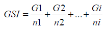
Conducted concomitantly with the germination test, with a daily calculation of the number of seeds that presented protrusion of primary root with length ≥2 millimeter, continuously at the same time amid the trial. The germination speed index was calculated by Maguire formula [27]: aguire formula (1962):
Where:
GSI = seedlings’ germination speed index;
G = number of seeds germinated each day;
N = number of days elapsed from the seeding until the last count.

Root and Shoot Length

Root length was taken from the point below the hypocotyls to the end of the tip of the root. Shoot length was measured from the base of the root- hypocotyl transition zone up to the base of the cotyledons. The root and shoot length were measured with the help of a thread and scale.

Seedling Vigour Index

The seedling vigor index was determined by using the formula given by Abdul baki and Anderson [28].

Fresh and Dry mass

The fresh mass was quantified through weighing on precision scale, and the dry mass was determined through weighing on a precision scale after permanence of the material in a kiln with air forced circulation, at a temperature of 70°C, until indelible weight. At the ending of the experiment, At the end of the experiment, radical and plumule length and fresh weight measured. Plants were placed in the oven at 70°C for 48 h and weighted with sensitive scale.

Proline Contents

Proline was determined spectrophotometrically following the ninhydrin method described, using L-proline as a standard [29]. Approximately 300 mg of dry tissue was homogenized in 10ml of 3% (w/v) aqueous sulphosalicylic acid and filtered. To 2ml of the filtrate, 2ml of acid ninhydrin was added, followed by the addition of 2ml of glacial acetic acid and boiling for 60 min. The mixture was extracted with toluene, and the free proline was quantified spectrophotometrically at 520nm from the organic phase using a spectrophotometer. Statistical analysis each treatment was conducted, and the results were presented as mean ± SD (standard deviation). The results were analyzed by one-way ANOVA with used Minitab Version 16.

Results and Discussion

The present study showed clearly that salinity had a negative effect on the yield and its components of grass pea. It is well known that seed germination provides a suitable foundation for plant growth, development, and yield [30]. Increased salt concentration caused a decrease in germination percent (Table 1). Seed germination decreased as the doses increased. The Strong reduction in germination (-47%) was observed mainly at the highest level of salt concentration as compared to control treatment. Delayed germination causes increased irrigation cost and irregular and weak seedling growth in the establishment of legume crops. Relevant results were reported by Gunjaca and Sarcevic [31] and Almansouri et al. [32]. They reported that increasing osmotic potential decreased water uptake and slow down germination time. The average time of germination increases with increasing levels of salinity. In view of mean germination time, there was a considerable increase in this character at 0 (as control), 8 and 16 DS/m salinity levels as compared to the others. Emergence was significantly affected by salinity levels. Moreover, many researchers have reported developmental delay of seed germination at high salinity [33]. The germination rate decreased as salt concentration increased to a 16 dS/m and delayed for the high salt dosage (Table 1). Since higher salinity limited water absorption, it has prevented nutrient assimilation, as a result, germination rate declined with increasing salinity. The findings from this study were like to the findings of Kaydan and Yagmur [34] and Akhtar and Hussain [35].
Table 1: The interaction effect of NaCl and AgNPs on Germination Speed Index.
lupinepublishers-openaccess-journal-environmental-soil-sciences
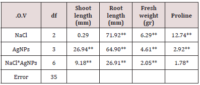
Table 2: Analysis of variance of the measured traits.
lupinepublishers-openaccess-journal-environmental-soil-sciences
Shoot fresh weight was significantly influenced (P<0.05) by salinity levels. The highest shoot fresh weight was obtained from 0dSm salinity level while the lowest weight was at 16dSm. Shoot fresh weight significantly decreased as salinity level increased above 8dSm (Table 2). Salinity stress significantly (P<0.05) affected shoot dry weight as the salt concentration dosage increased. Shoot dry weight significantly decreased in salt levels over 8dSm. When the salinity level was raised above, the proline content increased in grass pea. Culturing excised roots has demonstrated to be a really great test show for the early detection of tolerance to abiotic stresses such as saltiness [36-38].
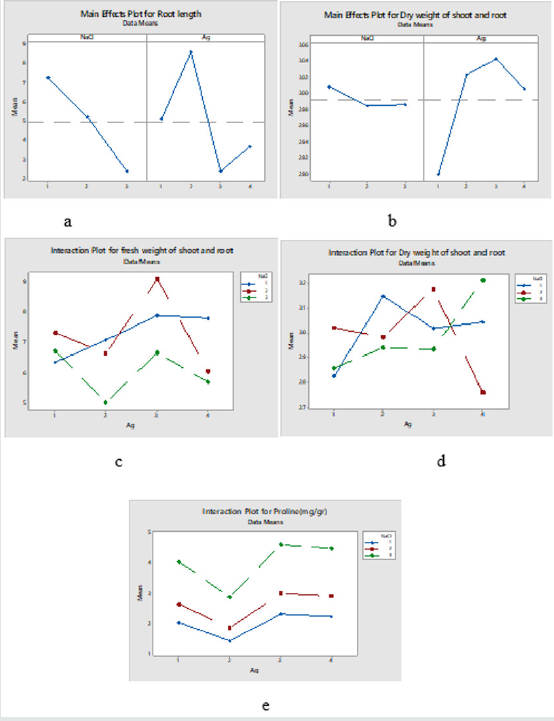
Proline was studied in numerous works dealing with plant selection against abiotic stresses such as dry and salinity [39,40], and it may play a defensive part against the osmotic potential produced by salt [41,42]. The proline substance of the expanded with the NaCl concentration of the culture medium. At 16 dS/m NaCl, the proline concentration appeared a huge increment in reaction to salt stress, although the activity of the roots at this concentration was negligible, with no grateful longitudinal development. Proline, which happens broadly in higher plants and collects in bigger sums than other amino acids [43], regulates the aggregation of useable N. Proline collection normally occurs within the cytosol where it contributes significantly to the cytoplasmic osmotic alteration [44]. It is osmotically very active and contributes to membrane stability and mitigates the impact of on NaCl cell membrane disturbance [45]. In the present experiment application of Ag NPs enhanced seed potential by increasing the characteristics of seed germination (Tables 1 & 2). The results showed that the impact of Ag NPs was significant on germination percentage in P≤0. 05. The results about of this test appeared that utilization of Ag NPs nanoparticles can increment the germination in grass pea. Seed germination results indicate that Ag Nanoparticles at their lower concentrations advanced seed germination and early seedling growth in grass pea, anyway at higher concentration showed slight antagonistic impacts. Parameters of seed germination were expanded with increasing levels of Ag NPs up to 10 ppm. Among the treatments, application of 10 ppm of Ag NPs proved best by giving the highest values for percent seed germination, germination rate and germination mean time. It is well watched that the exogenous application of Ag NPs decreased the reduction of germination resulted from salt treatments. In the interim, the control treatments of salt and Ag nanoparticles gave the tallest plants contrasted with the other studied treatments. Darvishzadeh et al. [21] found that the utilization of Ag Nano particles at the concentration of 40 mg.kg-1 prompted the increases in germination percentage and improved the resistance to salinity conditions in basil. The proline content increased with increasing severity of salinity stress. Additionally, proline content significantly (P.0.01) increased when silver nanoparticles were applied in connected in serious saline stress in comparison without silver nanoparticles (Figure 3).
Figure 3: Effect of interaction between ag nanoparticles and salinity on germination stages of Lathyrus Sativus L. a - Main effects plot for Root length (mm); b - Main effects plot for dry weight of shoot and root (gr); c - Interaction Plot for fresh weight of shoot and root (gr); d - Interaction Plot for dry weight of shoot and root (gr); e - Interaction Plot for Proline (mg/gr).
lupinepublishers-openaccess-journal-environmental-soil-sciences

Conclusion

Salt stress through enhancement of osmotic pressure leads to the decrease of germination percentage, germination rate, germination index and an increment in mean germination time of Lathyrus sativus seeds. For overcoming the negative impacts of salinity on the plant growth and yield can be to attempt to new strategies. The dry and fresh weight of seedlings diminished as seedling length declined with increasing salinity levels since root number, shoot number, root length and shoot length decreased essentially. Results demonstrate that Ag NPs at lower concentration enhances seed germination, promptness index, and seedling growth. The positive effect of Ag on physiological properties was in conditions that the plant grew under salt stress was more increasingly exceptional in examination with the conditions that plant grown under normal conditions. The results of this study showed that Ag can be involved in the metabolic or physiological activity in higher plants exposed to abiotic stresses.

For more Lupine Publishers Open Access Journals Please visit our website:
For more Open Access Environment Journal articles Please Click Here:
To Know More About Open Access Publishers Please Click on Lupine Publishers