Lupine Publishers | Journal of Anthropological and Archaeological Sciences
Abstract
For a long time all the data indicated that in the Early Pleistocene the South Caucasus was briefly inhabited by Oldowan people (Dmanisi site, ~1,8 MYR), whereas the Acheulian tool-makers appeared in the region only in the Middle Pleistocene. However, studies conducted recently in Armenia, South Caucasus revealed there two Early Pleistocene sites with Early Acheulian industries including around 4000 artifacts. On the basis of U-PB dating and paleomagnetic readings the key Karakhach site was attributed to the Olduvai subchron (1.95-1.78 MYR). The second site named Muradovo has no absolute dates but must be synchronous to Karakhach because of their similarities in both deposits and lithic industry. To judge by scarce paleoecological evidence these sites were occupied in conditions of subtropical climate and periodical volcanic ashfall. Almost all the Early Acheulian artifacts were made of natural slab-like pieces of local rhyodacite. Cores and flakes are rather rare. The large tools are dominated by pics, choppers and crude handaxes. There are also certain special tool types that along with very old age of the considered Early Acheulian industries suggest their local an autonomous appearance.
Keywords:South Caucasus; Early Pleistocene; Early Acheulian occupation
Introduction
Before the beginning of the present century there was only a
single evidence of human occupation of the Caucasus in the Early
Pleistocene. It was the Dmanisi site, Georgia (South Caucasus)
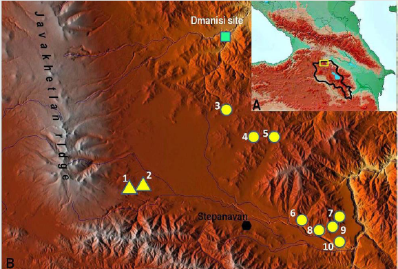
(Figure 1) where deposits dated around 1.8 MYR contained a
typical Oldowan industry (small core-choppers and flakes) in
association with remains of early hominids [1-3]. Acheulian
artifacts found in the region were collected primarily in the
numerous surface occurrences and dominated by flat and carefully
flaked handaxes indicating Late Acheulian age [4-6]. A majority
of these localities were discovered in the volcanic uplands of the
South Caucasus (Armenia, southern districts of Georgia) where
typical Late Acheulian handaxes are accompanied by the Levallois
products. Judging by both absolute dates and bio-stratigraphic data
for few stratified sites (Azykh, Kudaro I и III, Cona, Nor Gekhi 1)
the Late Acheulian industries existed in the different parts of the
Caucasus in the interval around 600-300 KYR [7-10], i.e. in the
Middle Pleistocene. Hence, all the research results suggested an
enormous chronological break between the Oldowan and Acheulian
occupations of the region [6].
However, there were also some reasons to doubt in so late
appearance of the Acheulian tool-makers in the Caucasus in
comparison with other regions. Today it is known that the earliest
Acheulian industries in Africa originated in the East African rift
zone just after 1.8 MYR [11-15]. These lithic industries with
complicated technologies and diverse large tools (crude handaxes,
pics, cleavers, choppers, large scrapers etc.) developed in conditions
of semi-open volcanic landscape and on the base of local lava rocks.
The first manifestation of the Early Acheulian in the Near East was
revealed in the Ubeidiya site (Israel) dated to 1.4-1.6 MYR [16, 17]
and located in the Syrian-Arabic, or Levantine rift zone continuing
the East African rift system. The Early Pleistocene ecosystems
within these areas were analogous and favorable for the Acheulian
tool-makers [18]. Since the considered tectonic structures extend
further to the south of the Caucasus on may expect to find there a
similar palaeoecological situation [6]. Then, it is impossible to
agree with N. Rolland that the Armenian high plateau situated
between the Near East and the Caucasus was a physical barrier for
inter-regional migrations of Early Paleolithic populations [19]. In
any times humans were able to overcome this upland thanks to long
river valleys and intermountain depressions cutting the high relief
in sub-meridional direction [20]. During the Early Pleistocene there
was a less elevated relief that facilitated moving of early humans
within and across the upland [6, 21].
The northern volcanic areas of the Armenian plateau occupy the south of the Caucasus isthmus. During the Early Pleistocene in the Southern Caucasus there were diversified environments with small-scale topographic complexity (cliffs, lava flaws, natural traps etc.), available water supplies (lakes, springs) and varied food resources obtained from mosaic landscapes [6, 22]. These conditions are believed to be very suitable for inhabitance of Early Paleolithic humans. Moreover, the palaeoenvironmental setting of the Dmanisi site located in the South Caucasus shows striking similarities to those of East Africa and the Middle East such as volcanic landscape with small lacustrine basins and the combination of open and wood ecotones [23]. To judge by analysis of both pollen and fauna composition of the Dmanisi site, around 1.8 MYR in the South Caucasus there was a semi-dry and warm climate similar to the present-day climate of the Mediterranean region [1, 24]. Then, the southern areas of the Caucasus must be especially attractive for Acheulian people thanks to abundance of various volcanic rocks of high knappable qualities which were available as large-sized pieces. It was the ideal raw material for the production of various large tools (handaxes, cleavers, pics etc.) and large flake blanks characteristic for the Acheulian techno-complex [6]. Hence, there are certain prerequisites for an earlier appearance of the Acheulian in the South Caucasus. To verify this speculation, it was necessary to search there for the Early Pleistocene tool-bearing deposits. Accordingly, the specially-purposed studies have been arranged in the beginning of this century in the territory of Armenia.
Materials and Methods
In 2003 the joint Russian-Armenian expedition launched studies for Lower Paleolithic and especially Acheulian traces in the north of the Armenian volcanic upland (South Caucasus, Armenia), in the Lori intermountain depression [6, 25, 26]. This area (Figure 1) was believed to be prospective because of proximity to the Dmanisi site and abundance of lava rocks of the Early Pleistocene age [27, 28] which may be used for manufacturing Acheulian large tools. The lavas as well as tuffs and ashes erupted by the local Javakhetian ridge in the interval of 2.65-1.7 MYR occur in most sediment sections of the area and provided an opportunity for U-Pb absolute dating of the Acheulian artifacts found in these deposits [29]. The dating results were validated with a series of paleomagnetic readings [28]. While no paleontological remains preserved in the acidic volcanogenic sediments, some palaeoecological data were obtained by an analysis of paleosoils [30] and phytoliths, i.e. petrified plant remains. The tools were described in accordance with the classification systems designed for the Early Acheulian industries of Africa and the Near East [31, 32].
Studies of the reference Early Acheulian sites
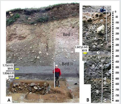
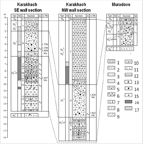
The studied area is the Lori intermountain depression (1400 – 1800 m a.s.l.) located near to the northern border of Armenia (Figure 1). A bottom of the depression is filled by the Gelasian basalts and basaltic andesites with K-Ar dates from 2.51+0.12 to 2.08+0.10 MYR [27, 28]. The lavas came from the volcanic Javakhetian ridge, which flanks the depression in the west. Nearly to this ridge two sites with the very early Acheulian-bearing deposits have been discovered (Figure 1, 2). The key site was revealed in the Karakhach quarry (N41°04ʹ25.64ʺ; E44°07ʹ14.25ʺ; H=1800 m) located at the foot of the Javakhetian ridge [26, 33]. At Karakhach the sediment sequence is observed in two walls of the quarry and in several test pits. The sediments may be subdivided into three principal units designated as the Beds I-III [28]. In the larger north-western wall the sediment sequence is as follows (from the top to downwards (Figure 3):
I. Non-stratified unit composed of badly rounded pebbles
and boulders of different volcanic rocks that could be
sedimented by a mud-rock flood; up to 9 m. The lower 2.5 m
part of the unit has the reverse and lower has normal magnetic
polarity
a) White ash with the normal magnetic polarity; up to 0.4 m.
b) Gravel-sand lens with dispersed pebbles; up to 0.8 m. The
upper part of the lens shows the normal polarity and the
lower part shows the reverse one.
II. Poorly stratified unit of dacite agglomerate tuff, possibly
redeposited in the upper part; up to 5 m. The tuff consists
of pumice-like clasts of the pebble and rarer boulder size
cemented by ach. The SIMS U-Pb dates are 1.944+0.046 MYR
0.5 m above the visible bottom of the quarry and 1.826+ 0.02
MYR in the top of the tuff [28, 29].
III. Lens-type layers of boulders and finer gravel with loam,
sand matrix and interbeds of dacitic ash; 3.5 m (visible in the
test pit 1).
In the south-eastern wall of the quarry the bed I is reduced up to 1.5 m. The lower part of the bed has the reverse magnetic polarity. The layers Ia и Ib are absent. The layer II (tuff) is 3.1–3.2- m thick and shows the reverse polarity. There are the SIMS U-Pb dates: 1.75+0.02 Ma in 1 m from the bottom and 1.804+0.03 Ma directly above the bottom of the tuff. Additionally, the SIMS U-Pb date 1.799+0.044 Ma was made for the middle part of the Bed II somewhat beyond. The lower levels of the Bed II show the reverse magnetic polarity [28, 29].
The Bed III in the south-eastern part of the quarry was partly excavated in the test pit 2. The observable section 8.2 m thick consists of 14 layers:
a) 1-2: Brownish loams; 0.15–0.5 m. The layer 2 contains large boulders. Redeposited paleosoils [30] with phytoliths.
b) 3-6: Alternation of lens-type layers of boulders, pebbles
and finer gravel with loam and sand matrix; 2.7–3 m. All these
layers show normal magnetic polarity.
c) 7-9: Ash with the erosional top; ~0.7 m. There is the lens
of gravel and pebbles III.8 in 0.1–0.4 m from the top. The layer is
characterized by normal magnetic polarity The SIMS U-Pb date
is 1.947+0.045 Ma (28, 29).
d) 10: Boulders and pebbles with greyish sandy loam matrix
and the ash lens in the middle level; 2.2 m. The loam under the
ash has the normal magnetic polarity.
e) 11: Yellow-brownish loam; 0,15 m, paleosoil [30] with
phytolyths.
f) 12-14: Layers of boulders and finer gravel with loam and
sand matrix; 2 m. Layer 13 includes paleosoil [30].
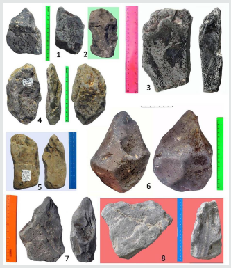
Acheulian artefacts were extracted from the Beds II and III [26, 33]. A majority of finds was made in the Bed III. The test pit 2 near the SE wall yielded 2963 lithic artifacts (Figure 4) extracted from the layers III.2-4 and III.6-14. The richest collections were obtained from the layers 3, 4, 6 and 10. The presence of such large tools as crude handaxes, pics and choppers is indicative of the Early Acheulian industries. Several large flakes marking the Acheulian technologies have been found too. Smaller tools include pointed tools, side scrapers and end scrapers, chisel-ended tools and other variable implements. As most tools were fashioned on natural slab-like pieced of rhyodacite as both flakes and cores are quite rare. Similar technological and morphological features of lithic artifacts in all the layers suggest a single Early Acheulian industry. Analogous artifacts (N=136) were also found in the test pit 1 exposing the Bed III near the NW wall. The lower levels of the Bed II limitedly excavated in the south of the quarry yielded 340 artifacts of andesite. There were several choppers and picks resembling those from unit III, but no handaxes. The Bed II industry is also distinguished for a larger portion of knapping by-products (flakes, chunks, cores) and the predominance of small-sized tools (end scrapers, side scrapers and pointed pieces). The Early Acheulian industry of the unit II may be a successor of that from the unit III. Certain differences may reflect adaptation to raw material of lower quality or/and functional features of the excavated areas.
Additionally, the Early Acheulian industry analogous to the Bed III industry of Karakhach have been found in the Muradovo site (1649 m a.s.l.) located 3.5 km eastwards, on the terrace of a small stream running from the Javakhetian ridge (Figure 1). At Muradovo the sediment sequence has been excavated up to the depth around 7 m from the terrace surface [25, 26, 33]. In the top there are thin horizons of the Holocene soil (layers 1-2) with clearly redeposited Late Acheulian pieces originating probably from eroded Middle Pleistocene sediments. The layer 3 is a yellow-brownish paleosoil yielding a more archaic Acheulian industry with single pics. The lower layers 4-5 and 7-9 may be described as sandy loams rich in boulders, pebbles and gravel, which resemble those of the Bed III at Karakhach. The layer 6 consists of volcanic ash but it has not been dated yet. To judge by increased parameters of magnetic susceptibility and high content of inorganic phosphorus the layers 4-9 were also deposited in conditions of more or less volcanic activity [34].
For today the layers4-9 of Muradovjo have yielded about 900 artifacts made of natural slab-like pieces of rhyodacite and andesite. Like in the Bed III of Karakhach large tools in the Early Acheulian industry of Muradovo are dominated by pics, choppers and crude handaxes [26, 33]. In both sites there are also some special tool types such as elongated bar-shaped chisels, fan-shaped choppers and short pics. Besides the Karakhach and Muradovo sites isolated finds of the typical Early Acheulian tools were made in several surface localities in the foothills of the Somkhetian ridge flanking the Lori depression in the east.
Interpreting the research results
The Karakhach quarry sediments lean against the slope of
trachydacites with K-Ar date of 1.96+0.08 MYR, which probably
form the rock bed of the section. Taking into account the series of
absolute dates and paleomagnetic data the Bed III with numerous
Early Acheulian artifacts is attributed to the Olduvai subchron with
a normal polarity (1.95–1.77 MYR). The overlying Bed II (tuff) with
rare Early Acheulian pieces showing primarily reverse polarity
deposited in the beginning of the Upper Matuyama, i.e. a little
earlier than 1.77 MYR [28]. Most Acheulian layers of the Bed III
contain boulders, pebbles and gravel resulted from water activities.
However, poor sorting and unequal rounding of the rock fragments
indicate rather temporal streams as well as slope washing including
local mud flows of low power. The Early Acheulian artifacts have
been were found in two test pits at the distance about 100 m and
most pieces were slightly rounded. They are unlikely to occur in
situ but the displacement was hardly distant. One may suppose that
Early Acheulian people lived there not in a certain camp but rather
in the particular habitat with small and periodical watercourses
that rounded and removed the discarded artifacts within the place
before became completely buried. At the same time, both paleosoils
and ash lenses preserved within the Karakhach sediment sequence
suggest that there were also some periods without considerable
water activity. Compared to Karakhach the Muradovo site is
situated 3.5 km further away from the Javakhetian ridge and has no
absolute dates yet. However, the lower pebble and gravel deposits
of Muradovo are very similar to those of Karakhach excluding a presence of interbedded paleosoils [28] and contain an analogous
Early Acheulian industry [26, 33] that indicate the same or, at least,
somewhat younger age within the Early Pleistocene.
Up to the present certain data on climate and lahdscape were
obtained only for the Karakhach site. To judge by characteristics
of three paleosoils within the Bed III they formed in sub-tropical
conditions [30]. The numerous fytoliths extracted from these
paleosoils show the predominance of subtropical plants (A.A.
Golyeva, pers. com.). The same climate and vegetation have been
interpreted from pollen data for the coeval Oldowan site at Dmanisi
[1, 24] situated not more than 25 km north from Karakhach. Given
more or less amounts of ash in the Bed III at Karakhach and layers
4-9 at Muradovo, in the period of their formation (subchron Olduvai
and possibly somewhat later) the local Early Acheulian people lived
in conditions of periodical ashfalls. The Bed III at Karakhach is
covered with thick tuff deposits consisting of ashes and pyroclasts
(Bed II) where Acheulian pieces were met only in the lower horizons.
So, just after the subchron Olduvai an increased volcanic activity
gradually led to termination of the Early Acheulian occupation in
the Karakhach habitat and probably in its surroundings too.
Concluding Remarks
The reliable results of studies conducted recently in Armenia had revealed that in the South Caucasus there was no chronological hiatus between the Oldowan and the Acheulian occupations. The Acheulian tool-makers first appeared in the region Southern Caucasus in the very Early Pleistocene and inhabited there during the Olduvai subchron (1.95–1.77 MYR) together with the Oldowan people. Then, it should be pointed out that the considered industries have even an older age then the Early Acheulian in East Africa and differ from the latter in both technologies and tool types. In most Early Acheulian industries of East Africa large tools were fashioned mainly on large flakes and for this reason were dominated by handaxes and cleavers. This technological variant of Acheulian was designated by G. Sharon as the Large Flake Based (LFB) Acheulian [35]. In contrast, in the Early Acheulian industries of the South Caucasus a majority of tools was made of natural slablake pieces. In this Slab-like Blank (SB) Acheulian large tools are dominated by pics combined with choppers and crude handaxes without any cleavers. Some special tool types such as elongated chisel-ended tools, choppers of sub-triangular and sub-rectangular form and some others were defined too [33, 36]. Both very early dates and particular features of the considered industries suggest a possibility of autonomous appearance of the Acheulian in the South Caucasus. Then the local Early Acheulian is continued in local Middle Acheulian [33]. It should be noted that another Early Acheulian industry of similar age (1.95–1.78 MYR) was discovered in the Taman peninsula, North-Western Caucasus [37], where might be one more center for development of Acheulian. This evidence perfectly fit with the concept stating that the Acheulian techno-complex independently originated in multiple places of the Old World [38].
Acknowledgments
The author is grateful to the former director of the Armenian- Russian archaeological expedition S. Aslanyan and its present director A. Petrosyan for the possibility to take part in field work in Armenia. Then many thanks are expressed to numerous archaeologists and specialists in natural sciences who provided successful digging the considered sites as well as collecting and interpreting various data. The studies presented in the paper were funded by the Russian Foundation for Basic Research, project 18- 00-00592.
Read More About Lupine Publishers Journal of Anthropology and Archaeology Please Click on Below Link:
https://journalofanthropologicalsciences.blogspot.com/


No comments:
Post a Comment
Note: only a member of this blog may post a comment.