Showing posts with label Journal of anthropological Research. Show all posts

Thursday, 7 September 2023

Lupine Publishers | Decorating or Money: An Alternative on the Example of the Multi-Layered Paleolithic Site of Kostenki (Russia)

 Lupine Publishers | Journal of Anthropology & Archaeology


Opinion

The use shells of molluscsas money is well known in world history. This precedent ended only in the last century. But, the beginning of such use is lost in the depths of the Paleolithic. Reliably established facts of the most remote from modern times, the use of shells as money is known in China (3500 years ago). The possibility of using mollusk shells as money is considered in the abstract on the example of the multi-layered Paleolithic site of Kostenki in the Voronezh region. This Paleolithic site is one of the most studied in Russia. Note at once that there is no direct evidence of the use of shells as money, but the very way of life of Paleolithic man in Kostenki and some features of the structure of mollusk shells, their species identification indicate a high probability of such use.
The location of the site. The increase in population and competition for food resources pushed Paleolithic man to move to the deserted North, to the periglacial zone of glaciation on the Russian plain. However, it was impossible for a Paleolithic man to live on it due to unfavorable conditions (low air temperatures, low precipitation). However, man has found an oasis in this periglacial desert. They turned out to be deep ravines and gullies that go out into the valley of the then not very deep Don river on the Kostenki-Borshchevo section. There were springshere during the Interstadial period. There was a river nearby, a thicket of vegetation with edible berries, and on the plateau there were herds of undaunted mammoths, horses, and other animals. This did not always continue. People were forced to migrate to the South during the Stadial cold, the permafrost, the disappearance of springs.People again mastered with improved climate conditions to the ravines and gullies of the Don after hundreds of years or even millennia. Traces of Paleolithic human activity are reflected in the multi-layered sites of the Kostenki-Borshchevo section .
Economic activity of Paleolithic man. People of the Paleolithic society had to adapt to survive in the harsh conditions of the ice age, to specialize in the extraction of natural resources. Only a few people possess the skills of hunting for wild animals, especially the mammoths. It was necessary to have a certain skill to catch, for example, a horse or an arctic fox. Not all, but only “narrow specialists” could butcher the carcasses of the extracted animals. Special skills, special raw materials were needed to make hunting tools. Concretions of black opaque flint from the Cretaceous rocks were the best rock for the production of tools and hunting. Such flint had to be extracted from the layers of chalk exposed on the slopes of the steep walls of the ravines. Oxidized (exposed to long-term exposure to air) flint was used for black flint deficiencies. Quartzites, silicified limestones from Devonian rocks, sand concretions, and glacial boulders were used less frequently as tools. Skills and abilities were necessary to maintain a fire (bonfire) for cooking, take care of children, collect plant food (raspberries, cloudberries, possibly mushrooms), build structures for housing using mammoth bones, fish, and make art objects. Consequently, farming was not spontaneous at the end of the Middle and beginning of the Late Paleolithic, judging by the multi-layered sites in Kostenki. It looked, on the contrary, organized, complex. Leaders and chieftains were in Paleolithic societies. They stood out for their skills and, perhaps, strength. But they could not ensure the functioning of primitive society.There was a need for the existence of an “economic” lever, through which the management of society became relatively unproblematic. Such a lever is most likely to be works of art, including crafts such as arctic fox teeth, and small attractive natural objects in the form of preferred (including marine) mollusk shells.
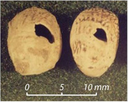
Shells of mollusks as a possible monetary unit.Shells of continental (land and freshwater) and marine mollusks were found in the deposits of the multi-layered Paleolithic site of Kostenki.L and mollusksexistedinvisiblywithPaleolithicman. These were mainly soil periglacial species from the so-called loess complex. Species associated with herbaceous plants of submerged biotopes were observed less frequently, only during the warming phases. Shells of freshwater species that can exist in small pools have been singly recorded in the fauna of Kostenki 14 [1]. Paleolithic man deliberately brought the shells of the following river mollusks to the site: Theodoxus cf. fluviatilis (Linnaeus), Lithoglyphus naticoides (Pfeiffer), Valvata naticina Menke, and unidentifiable members of the Unioidae family. Shells of the mentioned river species are found only in cultural layers. They could not inhabit the waters of the Don river in the vicinity of the Kostenki section.These are interglacial and Holocene species that existed on the Russian plain in river waters outside the permafrost zone.Shells of Theodoxus cf. fluviatilis (Linnaeus) should be considered separately. First, the shells of this species have artificial holes, designed according to archaeologists for wearing pendants. Meanwhile, there are no signs of long-term use as suspensions on part of shells with artificial holes.It is possible that these shells, which are small in size, were simply strung on thin branches of plants or on a thread for transportation, including over long distances. It was hard to lose them in this position. Secondly, the species identification of shells raises questions. The fact is that the shells of the European species Theodoxus fluviatilis (Linnaeus) are very similar to the shells of the Pontic-Balkan mollusk Theodoxus danubialis (C. Pfeiffer). The difference between them is mainly in the color of the shells and the features of the pattern. The surface of the shells of the species Th. danubialis (C. Pfeiffer) has a bluish-purple hue and a banded pattern, while the shells of the related species Th. fluviatilis (Linnaeus) the color is mostly reddish-purple with a mottled pattern. The surface color of the shells from the site Kostenki 14 (Markova Gora) was changed under the influence of oxidative processes during their stay in the soil-loess layer. However, the poorly preserved pattern on some shells still suggests that some of the shells belong to the species Th. danubialis (C. Pfeiffer) (Figure 1).

Figure 1: Shells of Theodoxus danubialis (C. Pfeiffer) with artificial holes from the archaeological site of Kostenki 14.
Lupinepublishers-anthropological-and-archaeological-sciences

This means that the shells were brought by Paleolithic man to Kostenki from a very narrow area, from the lower Danube river basin, where the species was in a refugium during the global cold snap (glaciation) in Europe.Having made such a journey from the mouth of the Danube to the Middle Don, shells became a valuable commodity that could be used as decoration and as a monetary equivalent.
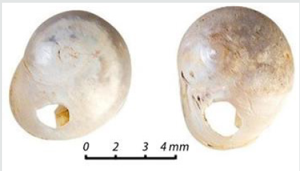
The shells of another species of river mollusks, not previously recorded in the Kostenki, were used by Paleolithic man as jewelry or even money.These are shells with artificial holes belonging to the species Valvata naticina Menke (Figure 2). Paleolithic man drew attention to these shells in connection with the porcelain-glossy luster, strength.The shells of this species, like those of Theodoxus danubialis (C. Pfeiffer), had to be brought from far away, from the lower flow of large low-lying rivers that flow into the Black and Caspian seas. This happened approximately 32 thousand years ago. The proposed route of the Aurignacian man with the shells Valvata naticina Menke, Theodoxus danubialis (C. Pfeiffer) was as follows: lower Danube - Kostenki 1 (Polyakov site), Kostenki 14 (Markova Gora).

Figure 2: Shells of Valvata naticina Menke with artificial holes from the archaeological site of Kostenki 1 [2].
Lupinepublishers-anthropological-and-archaeological-sciences

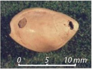
Sea shells with drilled holes in the cultural layer of the Kostenki site are represented by a single specimen of the young cowry Cyprea moneta Linnaeus, 1758 from the family Cypraeidae (Figure 3). (This shell is considered a member of the Collumbellidae family in the archaeological literature on the Kostenki site). The species Cyprea moneta Linnaeus currently inhabits the coasts of the Indian and South Pacific oceans.The Red sea is the closest habitat for cowries both at present and in the Paleolithic.Shells of this trade and monetary name cowry are found during excavations of Paleolithic sites in Europe, Africa, and the Middle East.Other marine organisms found at different times in the cultural layers of Kostenki 14, we point to the shells of the Mediterranean mollusk Nassarius nitidus (Jeffreys, 1867).

Figure 3: Shells of Cyprea moneta Linnaeus with artificial holes from the archaeological site of Kostenki 14 [3].
Lupinepublishers-anthropological-and-archaeological-sciences

ZA Abramova and AA Sinitsyn [4] believe that the shells from the Kostenki site were used only as beads and pendants.In our opinion, shells of mollusks, especially sea shells, had a value comparable to commodity money.It was necessary to make a long journey to the South, to the mouth of the rivers that flow into the Black or Caspian sea in order to deliver the strictly defined shells to Kostenki.The shells could be exchanged for something valuable from neighboring tribes. The most successful people of the Upper Paleolithic society, who could provide, for example, the maximum supply of meat in the form of a mammoth or reindeer carcass, were awarded with shells, beads, pendants made of Arctic Fox teeth, ammonites from Cretaceous deposits and other decorations.The Upper Paleolithic society in Kostenki probably consisted of successful, and therefore rich and less successful members. The symbols of wealth were the possession of the most original pendants made of mollusk shells and Arctic Fox teeth. Therefore, they served the role of money.

Read More About Lupine Publishers Journal of Anthropology & Archeology Please click on Below Link:
https://journalofanthropologicalsciences.blogspot.com/

Friday, 4 June 2021

Lupine Publishers | Historical Silahtaraga Power Plant-Black Sea Decovil Line Research, Double Military Decovil Photogrammetry Study

 Lupine Publishers | Journal of Anthropological and Archaeological Sciences


Abstract

In this article, which we prepared in addition to the works carried out by tracing a lost cultural heritage, In 1915 Turkish geography, investigation and photogrammetry study on the narrow-gauge railroad line built to transport coal from the Black Sea coast to the Golden Horn will be included. In the study, a CAD model created by measurements made from old photographs related to the subject will be used as data in the prototype to be produced by SLS (Selective Laser Sintering) method. Then, we believe that the miniature model and production adventure of the Decovil locomotive, which we have brought to the present with the noncommercial serial production of the model, will be the means of remembering at least a cultural heritage that has not reached today.

Keywords: Cultural Heritage; Photogrammetry; Additive Manufacturing; Double Military Decovil

Introduction

In this part of the study, the research of the historical railway and its archaeological importance will be shared. In this review, news published on the internet pages and books and some collection materials prepared by the researchers were used. The narrow-gauge railroad line located in the boundaries of Istanbul, in Kagithane district was founded in 1915. In order to uncover the lost story of this railway which ended in 1950 with the dismantling of the rails, a book published named “100 years later on the trail of a lost railway”. In the study carried out by the Municipality of Kagithane as a multi-disciplinary team, the team of writers created an important task in bringing the cultural heritage to the present day by bringing together the written documents, photographs and pieces of the railway which have the chance to reach today.

In the studies, many details related to the narrow-gauge railroad line, which was built for the purpose of transporting coal from the lignite basin in Agacli (25 km area starting from Kilyos to the Terkos Lake on the Black Sea coast) to the power plants in the Golden Horn, have been delivered to our day[1]. If we need to share some valuable details about the railway: The Kagithane- Black Sea decovil line, which was effectively used to meet energy needs during the First World War, was built between 1914 -1916 and is 57 km long (Figure1). The distance between the rails of the railway is 60cm and this system is called as decovil [2]. The name dekovil comes from the company founded in 1875 of the surnames of the French engineer and businessman Paul Decauville who lived between 1846 -1922 [3].

Figure 1: Distribution of archaeological sites in the Mouhoun Bend (Burkina Faso).

Lupinepublishers-anthropological-and-archaeological-sciences

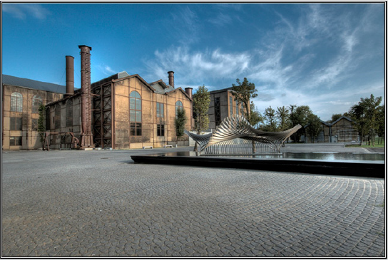
The period when the line was established, World War I continues in the region. There is an energy problem in Istanbul due to the imports of coal stopped from the UK due to the war and the damage of ships bringing coal from Zonguldak to the region during the war. The fact that the Canakkale Strait was closed due to the war made it impossible to import coal through the Mediterranean. In the Ottoman geography of the period, coal was used as an energy source in ships and power plants rather than domestic fuel. Today it is a museum building; the building, known as Silahtaraga Power Plant of the period, meets the electricity needs of Istanbul (Figure2). With the planned decovil line, it is aimed to evaluate the coal reserve on the Black Sea coast and to transport it to the Silahtaraga Power Plant without the need for sea transportation. In this way, the solution to the energy problem of Istanbul will be produced. Although the existence of the coal reserves of Agacli, Ciftalan region on the Black Sea coast has been known since the Byzantine Period, no studies have been conducted to make the reserve available for use. After the preliminary investigation, it is determined that the desired yield can be obtained by mixing the lignite coal in the region with Zonguldak hard coal, and it is decided to use the coal in the region and construction of the decovil line is started. The entire installation works are photographed by Hasan Mukadder Dolen, the railway regiment officer of the period.

Figure 2: Distribution of archaeological sites in the Mouhoun Bend (Burkina Faso).

Lupinepublishers-anthropological-and-archaeological-sciences

The period when the line was established, World War I continues in the region. There is an energy problem in Istanbul due to the imports of coal stopped from the UK due to the war and the damage of ships bringing coal from Zonguldak to the region during the war. The fact that the Canakkale Strait was closed due to the war made it impossible to import coal through the Mediterranean. In the Ottoman geography of the period, coal was used as an energy source in ships and power plants rather than domestic fuel. Today it is a museum building; the building, known as Silahtaraga Power Plant of the period, meets the electricity needs of Istanbul (Figure2).

With the planned decovil line, it is aimed to evaluate the coal reserve on the Black Sea coast and to transport it to the Silahtaraga Power Plant without the need for sea transportation. In this way, the solution to the energy problem of Istanbul will be produced. Although the existence of the coal reserves of Agacli, Ciftalan region on the Black Sea coast has been known since the Byzantine Period, no studies have been conducted to make the reserve available for use. After the preliminary investigation, it is determined that the desired yield can be obtained by mixing the lignite coal in the region with Zonguldak hard coal, and it is decided to use the coal in the region and construction of the decovil line is started. The entire installation works are photographed by Hasan Mukadder Dolen, the railway regiment officer of the period.

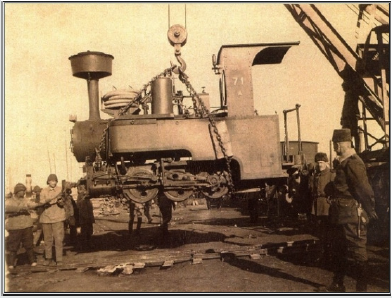
Hasan Mukadder Dolen’s photo collection was left to his grandson Emre Dolen after his death in 1975. It is known that many photographs and information about the historical railway have survived through this channel. Following the first line completed in 1915, a second line was built in Ciftalan in 1916. Railway rails and locomotives produced by Germany’s decovil line, with many stations, vehicles and employees is important in terms of energy logistics of the period. It is mentioned in the historical documents that the rails and locomotives transported from Germany to the Ayestefanos Railway Regiment warehouses in Yesilkoy by the Danube River were later brought to Eyup, Silahtaraga by ships (Figure3).

Figure 3: Distribution of archaeological sites in the Mouhoun Bend (Burkina Faso).

Lupinepublishers-anthropological-and-archaeological-sciences

The first line starts from Silahtaraga and reaches Agacli village after Kagithane stream; the other line runs through the Belgrade forests to the village of Ciftalan. The light rail line that reached the Black Sea coast from Kagithane, which is the famous promenade of the period, undertook an important duty in coal transportation during the years it was established, but was forgotten by being out of use in time.

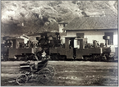
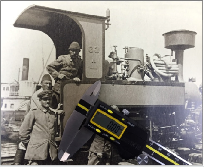
The line was transferred to the Ministry of Commerce in 1922 and to the Ministry of Economy after the proclamation of the Republic [4]. Although traces of the line disappeared in the region after 1956, the rails remained largely underground and in many regions the rails were removed. It is known that one of the locomotives is currently located in the Celtek coal mine depot of the Special Provincial Administration of Amasya. In the photogrammetry study for the protection of cultural heritage, CAD model will be created by using original photographs of locomotives known as Zwilling Heeres Feldbahn (Double Military Decovil) produced in Munich in 1890 by Krauss Werkshof [1] (Figures 4 & 5). The first prototype of the model produced with SLS (Selective Laser Sintering) one of today’s 3d print technologies, will be used for silicon mould technique in mass production.

Figure 4: Distribution of archaeological sites in the Mouhoun Bend (Burkina Faso).

Lupinepublishers-anthropological-and-archaeological-sciences

Figure 5: Distribution of archaeological sites in the Mouhoun Bend (Burkina Faso).

Lupinepublishers-anthropological-and-archaeological-sciences

Literature on Photogrammetry

In this part of the article, the photogrammetry study carried out with measurements taken from photographs of locomotives used in historical railway will be shared. In this context, sharing of literature knowledge about photogrammetry and its usage areas and then modelling study were included in the study. Visual analysis techniques are used in many scientific research areas. In the fields of anthropology and sociology, from the use of photographs of past periods [7] to airborne imaging technologies[8]; visual analysis techniques in different scientific fields from ecology, geography to medical science [9], are basically based on the use of photography as a source of information. Photographs used as data in the social field allow interpretations, social-cultural determinations and visual analysis of the time of the photograph [10]; in technical fields, it can also be used as a digital data source.

The use of photography for numerical data acquisition will be explained within the framework of photogrammetry concept. The word, which consists of a combination of ancient Greek “photos” (light), “grama” (drawing) and “metron” (measurement), means measuring with the help of pictures. Photogrammetry, which is used only in mapping, has been used in different areas in the following years. Basically, the photographic analysis to determine the shape, size and position of an object is called photogrammetry [11]. Photogrammetry is divided into three main sections (topographic photogrammetry, interpretation photogrammetry, special purpose photogrammetry) according to the application areas. Photogrammetry used in the fields of architecture, dentistry and archaeology is included in this third group [12].

In recent years, many studies have been done to document the cultural heritage with photogrammetric methods [13], photogrammetry has been used extensively in histor ical works documentation and model formation processes [12]. In such studies, the measurements taken on the photos allow the creation of the 3-D model of the historical work on the computer with digital photogrammetric techniques [14]. While the measurement process is carried out with the points and lines determined by the software, different methods can be used. In our study, the CAD model, which is designed with the measurements with calliper and ruler from old photographs, will be discussed within the scope of special-purpose photogrammetry.

Modelling Process

In this part of our study, we will discuss the modelling process created by taking measurements from the historical photographs of the railway line locomotive of Kağithane. In the modelling study, the locomotive CAD model was created in CATIA V5. The modelling; cabin, nose, mechanical parts and rails, including a total of 4 body consists of (Figure 7).

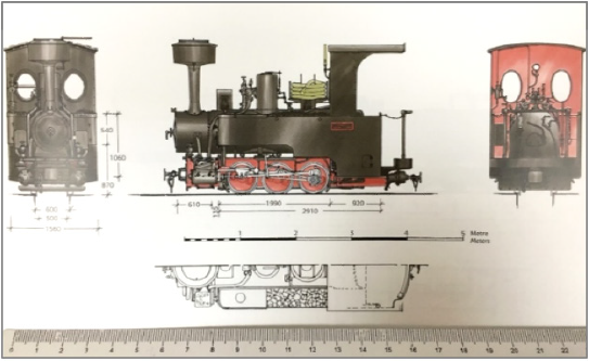
Part design tools are used in the modelling. The modelling of the locomotive as 4 bodies is taken into consideration for the production criteria for the silicone mould to be needed during mass production. In this sense, the model has been modelled and divided into pieces so as to enable post-production assembly. In the modelling study, first the technical drawings (Figure 6) made by Alan Prior were used for general information about the model; in the detail drawings, black and white photographs taken from different angles were used. After the results of modelling, some forms are very detailed for the casting process and line softening is performed according to the model casting process (Figure 7).

Figure 6: Distribution of archaeological sites in the Mouhoun Bend (Burkina Faso).

Lupinepublishers-anthropological-and-archaeological-sciences

Figure 7: Distribution of archaeological sites in the Mouhoun Bend (Burkina Faso).

Lupinepublishers-anthropological-and-archaeological-sciences

Data Transfer to 3d Printing System After Modelling

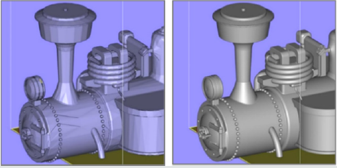
(STL File, Quality Problems) STL (Stereolithography) data is needed for additive manufacturing of the model. The CAD data generated for this reason is exported in the STL format in the CATIA software. In this process, STL mesh quality is important for the surface quality of the model to be produced. The quality of the prototype to be produced with SLS will affect the quality of the silicone mould from this prototype. The quality problems in the STL data are related to the number of mesh on the surface and the settings of the CATIA display and the necessary arrangement is made as follows: First, the screen settings are set in the ”tools“ - ”options” – “performance” section in the top menu of the CATIA Part Design module. In this section, the 3D Accuracy and 2D Accuracy “fixed” values are revised to “0.01”. The value 0.01 remains constant until changed again.

The next editing is done in the CATIA STL Rapid Prototyping module. In the “tesselation” command, with “sag” value, 0.001mm and “grouped” option preference, the mesh quality of each part is determined (Figure 8: on the effect of mesh quality adjustment on surface quality in STL data).

Figure 8: Distribution of archaeological sites in the Mouhoun Bend (Burkina Faso).

Lupinepublishers-anthropological-and-archaeological-sciences

Model Production Process

The technique used in the prototype production is SLS (Selective Laser Sintering) and the material used is PA 2200 (polyamide). If we need to give basic information about SLS production system: The SLS technique is made by sintering micron-size polymer powder in layers, using laser power. In 1986, Carl Deckard, a student at the University of Texas, developed this method of powdered material, which he called PGLSS (Part Generation by Layer wise Selective Sintering). Later on, this production technique called SLS, (with the description text: computer-aided laser apparatus which sequentially sinters a plurality of powder layers to build the desired part in a layer-by-layer fashion) is patented on October 1986 [15]. The method of SLS production is as follows:

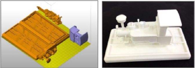
Firstly, files saved in STL format are opened in Netfabb software and settled in the production area. (Figure5). All parts are sliced at intervals of 0.1 mm (100 microns) after placement. Then the file sliced into 100 microns is saved in SLI format. Although there are 60 microns slicing options within the system, 100 microns will be sufficient for the desired quality. Then the process will continue in the EOS PSW software. After the material preference and parameter selection in EOS PSW software, the file will be transferred to the production bench. The material preference is selected as PA2200 and the layer thickness is 100 microns. The production parameter is then determined. After the prototype production to be performed in EOS P110 (Figure 9), silicone moulding will be carried out for mass production.

Figure 9: Distribution of archaeological sites in the Mouhoun Bend (Burkina Faso).

Lupinepublishers-anthropological-and-archaeological-sciences

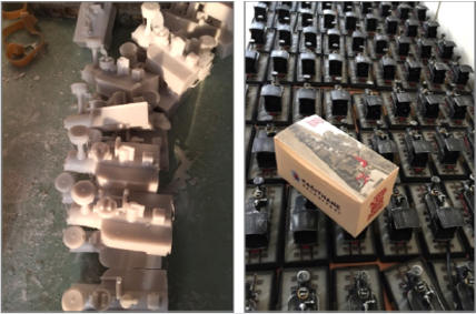
The first prototype produced with PA 2200 material, is used to form the silicone mould. After that, the model which is replicated in the manufacturer company by casting process from polyester material is painted with handwork and the final product is obtained (Figure 10). In classical applications, the silicone mould is taken from the prototype modelled by the sculptor and polyester casting process is performed. In the prototype production subject to our study, the process was completed by using digital technologies and methods. In the study, modelling was performed in parametric cad software, enabling the revisions needed in the process to be made quickly.

Figure 10: Distribution of archaeological sites in the Mouhoun Bend (Burkina Faso).

Lupinepublishers-anthropological-and-archaeological-sciences

Thursday, 18 March 2021

Lupine Publishers | The Dynamics of Mounds-Clusters in the Mouhoun Bend (Burkina Faso)

 Lupine Publishers | Journal of Anthropological Sciences


Abstract

Mounds are human made accumulations of settlements debris of varying size and shapes, found in different parts of the world. In West Africa, they tend to be located in relatively flat lands, at low elevations, in wetlands, marshlands or flood plains. Some are large single mound sites. Others are made of groups of scattered or clustered mounds – mound-clusters -, spread over varying surface extent. The dynamics of such settlement systems is still poorly understood partly because of inadequate field methodology. Ethno-historical and ethnographic data from West Africa recent past are relied upon to suggest some of the key processes behind mounds clustering: ethnicity, craft affiliations, or a combination of both. The Mouhoun Bend Archaeological Project (MOBAP 1997- 2000) was designed to address this issue. The field methodology was articulated on testing all mounds parts of the mound-clusters under investigation. Two mound-clustering strategies were identified:

a. Tight-clustering resulting in the formation of a large “single mound site”, and
b. Loose-clustering with scattered individual mounds of different size and shape.

Residential and craft requirements combined differentially in the 2000 years Mouhoun Bend settlement history, have generated the settlement patterns investigated in the study area. The ethnicity component of the identified dynamics – that is plausible – could not be tracked with the current methodology and is accordingly undecidable.

Introduction

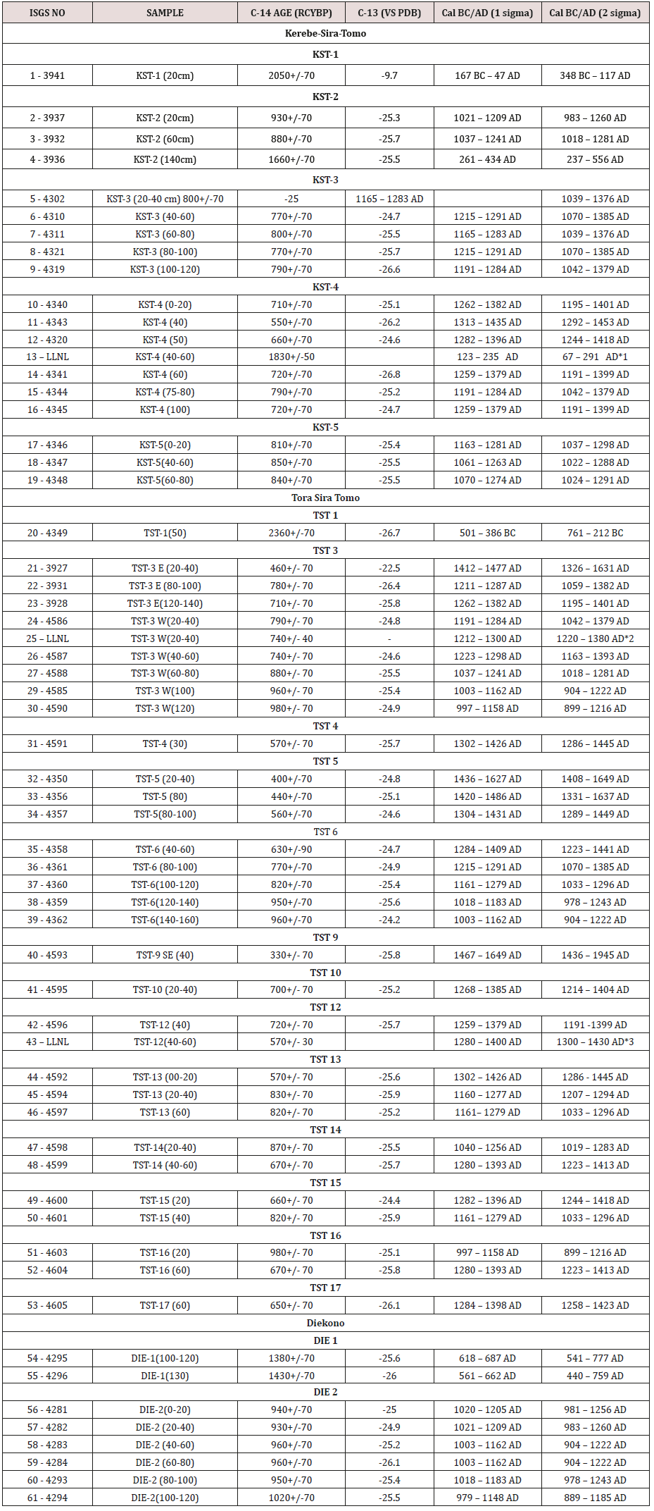
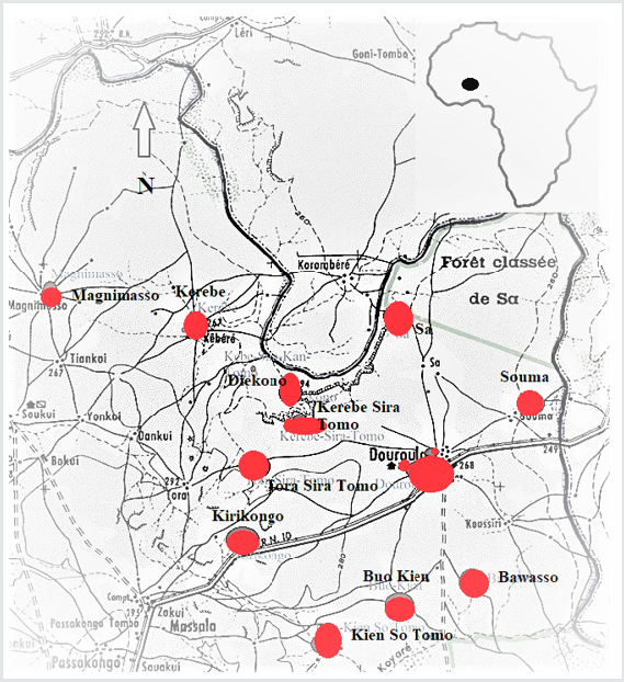
The Mouhoun bend was settled by iron-using communities in the first millennium BCE (Figure 1, Table 1). The climate was wetter [1]. The Sudanian savanna and the Mouhoun River offered a diversified resources mix that allowed for the stabilization and growth of these mixed farming fishing populations. Their settlements consisted of multi-mound complexes – moundclusters. The sample of sites excavated within the Mouhoun Bend Archaeological Project (MOBAP 1997 – 2000) offers an entry into the dynamics of this kind of settlement that developed and spread in the study area for a little more than 2000 years, from ca. 700/500 BCE to 1650 CE (Figure 1, Table 1).

Table 1: Radiocarbon dates from the Mouhoun Bend Archaeological Project.

Lupinepublishers-anthropological-and-archaeological-sciences

Key: LLNL = Lawrence Livermore National Laboratory:
* Radiocarbon dates from iron objects processed by Dr. Andrea C. Cook at Lawrence Livermore National Laboratory, UC Berkeley.
*1 = from an iron ring
*2 = from a small iron spear
*3 = from a large iron spear

Mounds result from the piling up on the same spot of human occupation by-products. They include habitation features, craft installations, collapsed building material as well as discarded and abandoned material culture. They are therefore exclusively human-made and, depending on circumstances, can be either well preserved or significantly disturbed by erosion agencies. These formation processes that combine cultural (C-transforms) and natural (N-transforms) are well understood in general [2,3].

Habitation mounds dating from the Late Stone Age onwards are recorded in different parts of West Africa, from the Chadian basin to Mali and Guinea [4-18]. They consist either of a single small or large mound or of multiple mounds (mound-cluster). It has been suggested that mound-clusters may have derived from residential segregation, inhabited by different specialized more or less endogamic groups such as blacksmiths, potters, hunters, fishing folks, bards, etc. [19,20]. Distinct mounds are thus axiomatically considered to materialize residential segregation, and as such, are the signature of craft-specialization. The explanation is tautological. No excavation program was implemented to test the accuracy the hypothesis mentioned above. The testing procedure may have required an appropriate methodology, consisting at least of the probing of all the mounds part of the settlement complex under investigation, a precise and fine-grained chronology backing detailed analyses of material culture, architecture, and subsistence remains. It is then and only then that variation – or lack thereof – can be assigned to differences in social status. These principles have guided the field strategy implemented in the Mouhoun Bend Archaeological Project [21,22].

The Mouhoun River flows from the SW to NE, winds its course in a U-shape bend to follow a N-S direction (Figure 1). The study area located in the Sudano-sahelian zone is delimited in the north and northeast by the meandering river course. It measures 40km East-West (3o 11’ North / 3o 32’ East) and 38km North-South (12o 30’/ 12o 45’ latitude North). The land, prone to cyclical droughts, is flat with elevation ranging from 294 to 249m above sea level. The vegetation is characteristically a highly anthropic wooded savanna, with the protected shea-butter tree (Butyrospermum parkii) largely predominant, followed by different kinds of Acacia sp.

Figure 1: Distribution of archaeological sites in the Mouhoun Bend (Burkina Faso).

Lupinepublishers-anthropological-and-archaeological-sciences

Three mound-clusters located in in different environments were selected for excavation: Diekono in the Mouhoun River floodplain, Kerebe-Sira-Tomo (KST) on the cliff delimiting the river valley, and Tora-Sira-Tomo (TST) and its satellite Gnambakouon-Sira- Tomo (GST) on the topographic rise in the central part of the study area. Each of the above mentioned sites is comprised of a number of mounds of different size and shape, iron-working workshops, and laterite quarries.

The Dynamics of TST and KST Mound-clusters

The long-term pattern of growth of inhabited space within a mound cannot be assessed with the field methodology implemented in this case, with one test unit per mound. A general time line of the settlement complex formation can nonetheless be reconstructed.

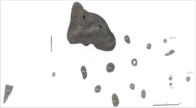
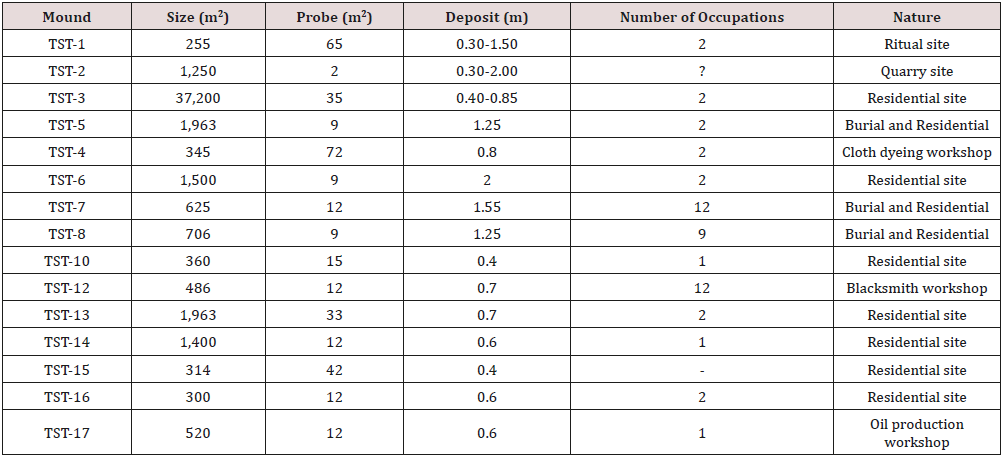
TST settlement complex (12o 35’ 07” N and 3o 22’ 07” E) is located at 280m asl. With 17 distinct mounds, it is the largest settlement complex of the study area, spread over 900m westeast and 500m north-south, some 45ha in total surface extent (Figure 2). TST-3, the largest mound stretched along the north edge measures 260m west-east, and 120m north-south. All 17 mounds were tested after three field seasons (1997, 1999, and 2000). Five, TST-1 (Iron smelting), TST-2 (quarry), TST-4 (cloth weaving and dyeing workshop), TST-9 (cemetery), and TST-17 (oil production workshop), are special purpose sites. The fourteen remaining ones were standard habitation mounds with varying occupation intensity

Figure 2: Tora-Sira-Tomo settlement complex.

Lupinepublishers-anthropological-and-archaeological-sciences

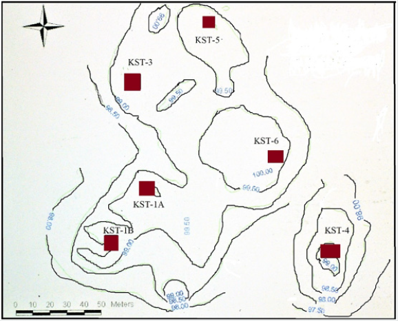
KST settlement complex is located on the cliff top along the edge of the Mouhoun River valley (Figure 3). The complex consists of eleven more or less distinct mounds stretched on 350m westeast and 600m north-south. The cluster is made of three distinct sites categories: a quarry (KST-2) located at some 800m east, iron-working stations both smelting and forging, and habitation mounds. Habitations mounds, clustered in the north, resulted in the formation of a large 15ha village site. All iron-working stations, arranged along a roughly ENE-WSW axis, are concentrated at 100 to 200m along the south flank of the main habitation cluster. KST settlement complex was inhabited from the second half of the first millennium BC to the second half of the thirteenth-century AD, with an important 500 years occupation hiatus in the second half of the 1st millennium AD. The development of TST and KST settlement complexes can be arranged in four successive phases, from the middle of the first millennium BC to the middle of the second millennium AD.

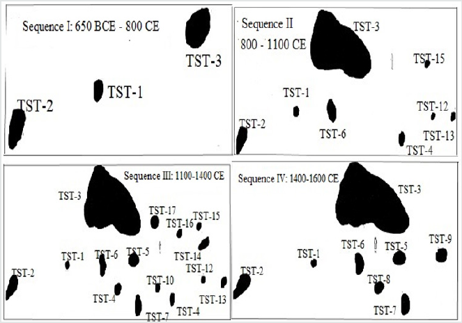
Figure 3: The evolution of TST settlement complex.

Lupinepublishers-anthropological-and-archaeological-sciences

Phase I (650 BC-800 AD)

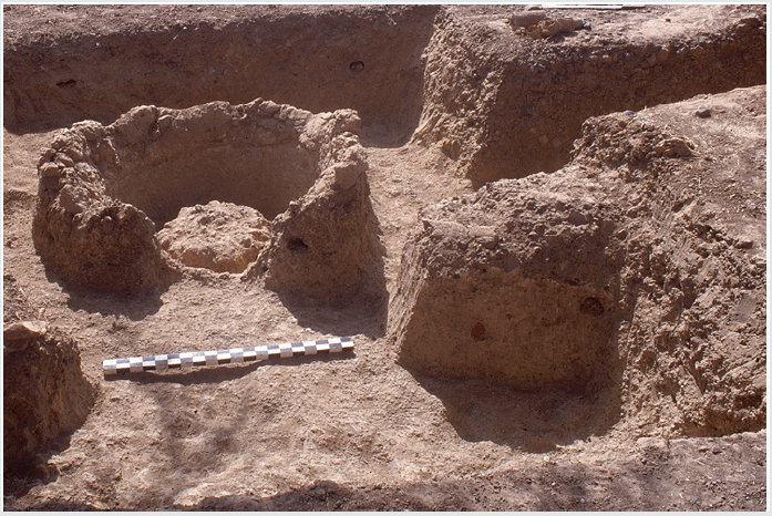
At TST, the initial settlement phase (650 BC-800 AD) that started in the mid-1st millennium BC is documented at TST-1, TST-2, and TST-3-East (Figure 4, Table 2). The earliest occupations are found at TST-1, an iron-smelting site dated to 650-395 BC (Figure 5), TST-2, the quarry site that provided raw material for house construction and iron production, and finally, the blacksmith workshop exposed at the bottom of TST-3-East probe.

Figure 4: View of TST-1 iron smelting furnace.

Lupinepublishers-anthropological-and-archaeological-sciences

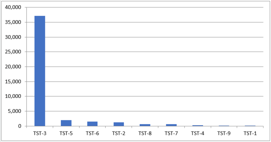
Figure 5: Differential mounds size in m2 during TST phase IV (1400 – 1650 CE).

Lupinepublishers-anthropological-and-archaeological-sciences

Table 2: Tora-Sira-Tomo mound cluster at Phase I (650 BC – 800 AD).

Lupinepublishers-anthropological-and-archaeological-sciences

KST settlement complex phase I dated to 350 BC-150 AD was shorter. It is documented in the west-central part of the complex, in KST-1A and KST-2 the quarry site (Figure 6). KST complex grew in two directions during its phase II dated to 250 – 550 AD. KST- 1B and KST-3 areas were settled. The mound was of an irregular potato- shape, oriented SW-NE. KST-2, the quarry site, was relied upon for the supply of iron ore and construction material during the whole existence of the settlement complex

Figure 6: Kerebe-Sira-Tomo settlement complex.

Lupinepublishers-anthropological-and-archaeological-sciences

Phase II (800 – 1100 AD)

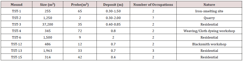
TST Phase II (800-1100 CE) settlement with a total of 8 mounds, witnessed the foundation of 5 new sites. They were arranged in two sub-clusters of four sites each: TST-1, TST-2, TST-3, and TST-6 in the west, and TST-4, TST-12, TST-13, and TST-15 in the east (Figure 4, Table 3). The western sub-cluster consisted of two residential mounds: TST-3 and TST-6, and two special purpose sites: TST- 1(iron-smelting and ritual) and TST-2 (quarry). The eastern subcluster includes TST-13 and TST-15 residential sites, and TST-4 (weaving and cloth dyeing workshop) and TST-12 (a blacksmith workshop) special purpose sites (Holl 2014). KST complex was abandoned during all the second half of the 1st millennium AD, from ca. 550 to 1000 AD.

Table 3: Tora-Sira-Tomo mound cluster in Phase II (800 – 1100 AD).

Lupinepublishers-anthropological-and-archaeological-sciences

Phase III (1100 – 1400 AD)

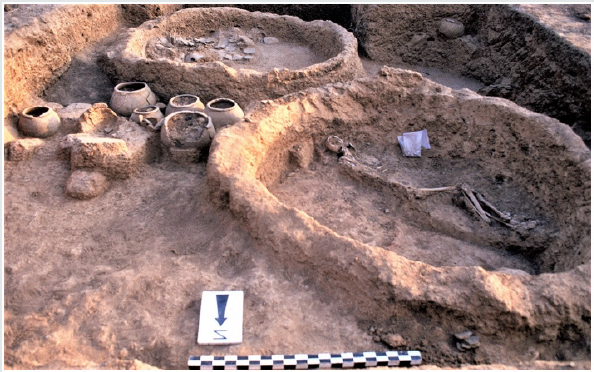
TST settlement complex reached its maximum extent during phase III (1100-1400 AD) with the addition of 7 new sites. All 15 mounds (Figure 4 & 7, Table 4) were located in the space delineated during phase I and II. The new additions are set in two patterns. TST-5, TST-7, TST-8, and TST-10 present a rectilinear arrangement of equidistant mounds at 100m from one to the next. TST-5, TST- 7, and TST-8 residential mounds ‘sits’ on burials dug deep in the laterite crust in what may have been an earlier cemetery. TST-14, TST-16, and TST-17 are along the northeastern flank of the complex, at 100m from one to the next, in a linear east-west arrangement. TST-14 and TST-16, were residential and TST-17 a karité oil production workshop.

Table 4: Tora-Sira-Tomo mound cluster in Phase III (1100 – 1400 AD).

Lupinepublishers-anthropological-and-archaeological-sciences

Figure 7: The evolution of KST settlement complex.

Lupinepublishers-anthropological-and-archaeological-sciences

KST complex also witnessed an accelerated growth during Phase III (1000-1250). KST-IA and 1B, KST-2 (quarry site), KST-3, KST-4 (occupation I and II), KST-5, and KST-6 (Figure 6) were all inhabited and in use. Fire destroyed habitation units from KST-3 occupation I and KST-4 occupation II (Figure 8 & 9), located along the southeast flank of the complex. There was also a significant intensification of iron-working, with the foundation of workshops devoted to iron-smelting, blow-pipes making, and blacksmithing along the south margins of the main village.

Phase IV (1400 -1650 AD)

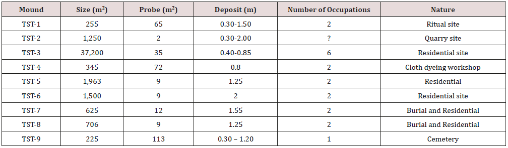
TST settlement complex shrunk significantly during Phase IV (1400-1650 AD). The number of inhabited sites dropped from 15 to 9. The eastern part of the cluster was abandoned (Table 5, Figure 4). A new restricted access cemetery was founded at TST-9. TST-3, TST-4, TST-5, TST-6, TST-7, and TST-8, were residential. TST-1, TST- 2, and TST-9, respectively iron-smelting site, quarry, and cemetery, were special purpose sites. In general, with the exception of TST- 8 set between TST-4 and TST-7 (Figure 4), the distance between neighboring mounds oscillates around 100m.

An identical phenomenon occurred at KST. The inhabited space also shrunk considerably during KST phase IV (1250-1450 AD) (Figure 6). Shallow occupation evidence is documented at KST-4 occupation III and IV, then used as a cemetery.

Figure 8: Partial view of KST phase III domestic unit.

Lupinepublishers-anthropological-and-archaeological-sciences

Figure 9: Habitation complexes from Phase III KST-4 .

Lupinepublishers-anthropological-and-archaeological-sciences

Table 5: Tora-Sira-Tomo mound cluster in Phase IV (1400 – 1650 AD).

Lupinepublishers-anthropological-and-archaeological-sciences

Variability of mounds clustering processes

Data collected from the excavation of four settlement complexes point to the existence of two main mound-clustering strategies: a tight and a loose one. KST settlement complex that lasted from ca. 350 BC to 1450 AD, with a half millennium occupation hiatus in the second half of the 1st millennium AD, features tight-clustering (Figure 7 & 8). All the residential sites, with the exception of KST- 4, are tightly packed in a 15ha village. Iron-working sites located along the south periphery of the village display no habitation. Craft people and work crews were KST villagers who commuted to their workshops during the iron-production seasons.

TST-GST settlement complex with a total of 20 mounds features the loose-clustering strategy. The mound-sites, 17 for TST and 3 for GST are well demarcated, with each sub-set presenting a large dominant mound. Residential and special purpose sites are represented in varying combinations all along TST settlement complex occupation history.

Archaeological data indicate that flexible strategies were adopted by the different ‘self-sustaining’ autonomous ancient villages during the 2200 years’ occupation of the Mouhoun bend. In KST, craft people resided in the village and commuted to their workshops located in the southern outskirts of the complex. In the TST alternative, with more or less inter-phase variations, craft people built their residence in distinct places and supplied local communities from their workshops. There is no fixed and permanent pattern of residential and occupational segregation in the analyzed archaeological record [21,22].

Peer-village interaction

The study area is relatively flat. The recorded settlement complexes are more or less evenly distributed in the landscape. In site-catchment analysis terms, each village is surrounded by rings of cultivated fields, fallow zones, and bush [23,24]. At their peak, during the first centuries of the 2nd millennium AD, each of the recorded settlement complex was a large autonomous and selfsustaining village. Some, like KST and Kirikongo, were compact villages with a few outlying mounds and special purpose sites. Others, as was the case for TST – GST and Diekono, were spread out with a multiplicity of distinct mounds.

There are no significant wealth differences. Grave-goods and burial offerings are too marginal to be significant. Some individuals, male, female, children, and infants, were nonetheless buried in “restricted access” cemeteries while others were buried in their compounds. This differential treatment points to subtle variations in social status without detectable and/or durable material correlates. The accelerated growth at the beginning of the 2nd millennium AD initiated a scramble for land, villages rivalry, violence, and wars.

Fire: accidents or wars?

Burnt houses were recorded in some of the excavated mounds. It is the case at TST-3-West in occupation I and II, dated to 1000- 1150 AD. Domestic installations belonging to two successive occupations were totally burnt down. KST complex also present two instances of burnt domestic installations dated to 1050 – 1380 AD: one at KST-3 occupation I and the other at KST-4 occupation II. In the latter case, a whole household complex with its food supply was destroyed by fire (Figure 9). Similar cases of burnt installations dated to 1300-1450 AD were recorded at Kirikongo, Mound III, level 8 and Mound IV, level 7 [8]. These events took place during a period of accelerated growth that triggered violent confrontations.

War, Violence and surgery

There is no direct one to one correlation but the unrest indicated by burnt houses is partly corroborated by traumatic injuries found on some of the deceased. Two male and female adult individuals buried in the same context at TST-7 appears to have been victims of the same violent encounter. One, a 35-50 years old adult female presents 4 well healed cranial fractures on the occipital, frontal, and left parietal. The other, an impressive 1.95m tall 45+ years old male presents two distinct episodes of trauma. He recovered from previous blows indicated by a well healed circular defect on the occipital. He has multiple trephinations with no signs of healing on the right, left parietals and frontal, showing that the second series of blows was fatal. Remarkably, both adults present similar blows patterns: they were hit on the frontal, occipital, left and right parietals, as if the aggressors were well trained fighters [25-27]. The surgery may have taken place after a violent raid. Finally, a 9-11 years old pre-adolescent, individual 18 from phase IV TST- 9 cemetery, presents multiple peri-mortem depressed cranial features made by a sharp object, that was very likely the cause of death [26].

The recorded evidence on traumatic injuries is dated to phase III (1000-1200 AD) and IV (1250-1500 AD) when the area witnessed a significant growth acceleration followed by the onset of devolution. There are convincing evidence of conflict and intervillage warfare during the first half of the second millennium AD. The nature and characteristics of the kind of warfare that may have developed in the area during this phase of accelerated growth are difficult to decipher. The tactics involved may have consisted of surprise raiding and counter-raiding with the aim of seizing supplies and host [27-37].

Conclusion

Each village had its autonomous system of government, with horizontally differentiated groups. These mixed farming communities included a number of craft specialists, potters, ironsmelters and blacksmiths, masons, cloths weavers and dyers, karite-oil producers, as well as part-time warriors, and healers (surgeons). The Mouhoun Bend peer-villages were autonomous and self-sustaining but not autarkic. A general compatibility of “worldviews” is suggested by the strong coherence of mortuary practices. Despite variations, pottery decoration techniques and syntax suggest a shared cultural universe. The mound-dwellers of the Mouhoun Bend developed an original socio-political system that, for approximately two centuries, from 1200 to 1400 AD, existed on the periphery of the powerful expansionist Mali Empire.

Acknowledgments

The Mouhoun Bend Archaeological Project (Burkina Faso 1997- 2000) was funded by a CNRS grant in 1997, a National Geographic Society Research Grant # 6378-98 in 1998, and a Faculty Startup Fund from the University of California, San Diego in 2000. The author is grateful of the support of these institutions and also wish to thank the CNRST – Centre National de la Recherche Scientifique et Technique – for the research permit and the Archaeology Laboratory of Ouagadougou University for logistical support. Students from the University of Paris X Nanterre, the University of Ouagadougou, and the University of California, San Diego participated with enthusiasm to the field programs.

Read More Lupine Publishers Archaeological Sciences Please Click on Below Link
https://journalofanthropologicalsciences.blogspot.com/

Wednesday, 11 March 2020

Lupine Publishers | Principles of the Military Consultations in Ancient Egypt

Lupine Publishers- Anthropological and Archaeological Sciences Journal Impact Factor


 Introduction
A way from the regular theory, that the royal king always had the perfect and ideal order and decision [1], when he always is depicting as an intelligent and wise man, making the correct solution against the doubts and uncertainties of his councilors [2], The pattern is basically that the king makes and demonstrates his superior judgment by the ensuing success [3].
From the beginning of the ancient Egyptian history, the royal king must had his own courtiers and advisors among the great ones [3A,3B], to consult with them, concerning the vital matters, especially when are relating to the country fate [4], the literary texts depicted several kinds of councils, whether were holding at the royal palace or outside it.
The first witness of holding a royal council was belonging to the 4th dynasty, at the reign of the great king Khufu, this council documented in Westcar papyrus [5] (= Berlin Papyrus 3033), when the great king Khufu summoned his sons to tell him an exciting marvel event that had happened in the past, the texts contains a cycle of tales within a single theme related to the birth of the kings who will succeed his line family rule, the episode begins when the king one day felt with a boredom, so he went around every chamber of his palace, finding something fun to entertain [6]. The story refers indirectly, the king’s need to own his close and special courtiers [7], who were emerging obviously at the Middle Kingdome literary texts (Berlin leather Roll of Senusert 1) [8].

Methodology
The research is concerned with the texts which refer to the royal consultation dating since the second intermediate period (Hyksos era) till the reign of the king Thutmose III, it contains four councils, three of them were held at the 2nd intermediate period (Apophis, Seqenenre and Kamose), while the 4th one belonged to the king Thutmose III’ reign.
The research will intend to analyze those councils, the reasons of its holding, members of the council and their positions, the place of its holding, the full dialogue that happened between the king and his councilors, and however the role of both (the king and his councilors) at these councils, as well as the results and the decisions which had been adopted.

Principle of Military Consultation in the Second
During the end of the 12th dynasty of the Middle kingdom [9], considerable details are indicating an increasing in numbers and activities of the Asiatics who infiltrated and settled around the eastern borders of the Delta [10], that settlement facilitated the operation of Hyksos invasion [11], which happened in the second half of the 13th dynasty of the Middle kingdom [12]. So, the country was divided into individual parts, the Hyksos invaders established the 15th dynasty, that predominated the whole Delta region until the middle Egypt borders at south, while the fugitive king of the 13th dynasty had to leave and ruled his remaining days of his reign to govern from Thebes [13], when the local governors of Thebes province hosted him and his royal family after the fall of the political capital el-Lisht, a short time passed, the Theban governors had inherited the kingship and authority and were establishing the 16th dynasty, which began the first liberal operations against the Asiatics invaders.
This latter dynasty was followed by a strong family (the 17th dynasty) whose kings began the true struggle and liberation wars against Hyksos, the first engagement occurred during the reign of Seqenenre Taa in the time of Ippy (Apophis) king of Hyksos.

For More Lupine Publishers Open Access Journals Please visit our Website:
For More Anthropological and Archaeological Sciences Articles Please Click Here:
To Know More About Open Access Publishers Please Click on Lupine Publishers

Follow on Twitter:  https://twitter.com/lupine_online


Wednesday, 4 March 2020

Lupine Publishers | Historical Silahtaraga Power Plant-Black Sea Decovil Line Research, Double Military Decovil Photogrammetry Study

Lupine Publishers- Anthropological and Archaeological Sciences Journal Impact Factor


Abstract

In this article, which we prepared in addition to the works carried out by tracing a lost cultural heritage, In 1915 Turkish geography, investigation and photogrammetry study on the narrow-gauge railroad line built to transport coal from the Black Sea coast to the Golden Horn will be included. In the study, a CAD model created by measurements made from old photographs related to the subject will be used as data in the prototype to be produced by SLS (Selective Laser Sintering) method. Then, we believe that the miniature model and production adventure of the Decovil locomotive, which we have brought to the present with the noncommercial serial production of the model, will be the means of remembering at least a cultural heritage that has not reached today.


Introduction

In this part of the study, the research of the historical railway and its archaeological importance will be shared. In this review, news published on the internet pages and books and some collection materials prepared by the researchers were used. The narrow-gauge railroad line located in the boundaries of Istanbul, in Kagithane district was founded in 1915. In order to uncover the lost story of this railway which ended in 1950 with the dismantling of the rails, a book published named “100 years later on the trail of a lost railway”. In the study carried out by the Municipality of Kagithane as a multi-disciplinary team, the team of writers created an important task in bringing the cultural heritage to the present day by bringing together the written documents, photographs and pieces of the railway which have the chance to reach today.

In the studies, many details related to the narrow-gauge railroad line, which was built for the purpose of transporting coal from the lignite basin in Agacli (25 km area starting from Kilyos to the Terkos Lake on the Black Sea coast) to the power plants in the Golden Horn, have been delivered to our day[1]. If we need to share some valuable details about the railway: The Kagithane- Black Sea decovil line, which was effectively used to meet energy needs during the First World War, was built between 1914 -1916 and is 57 km long (Figure1). The distance between the rails of the railway is 60cm and this system is called as decovil [2]. The name dekovil comes from the company founded in 1875 of the surnames of the French engineer and businessman Paul Decauville who lived between 1846 -1922 [3].

Figure 1: Distribution of archaeological sites in the Mouhoun Bend (Burkina Faso).
Lupinepublishers-anthropological-and-archaeological-sciences
The period when the line was established, World War I continues in the region. There is an energy problem in Istanbul due to the imports of coal stopped from the UK due to the war and the damage of ships bringing coal from Zonguldak to the region during the war. The fact that the Canakkale Strait was closed due to the war made it impossible to import coal through the Mediterranean. In the Ottoman geography of the period, coal was used as an energy source in ships and power plants rather than domestic fuel. Today it is a museum building; the building, known as Silahtaraga Power Plant of the period, meets the electricity needs of Istanbul (Figure2). With the planned decovil line, it is aimed to evaluate the coal reserve on the Black Sea coast and to transport it to the Silahtaraga Power Plant without the need for sea transportation. In this way, the solution to the energy problem of Istanbul will be produced. Although the existence of the coal reserves of Agacli, Ciftalan region on the Black Sea coast has been known since the Byzantine Period, no studies have been conducted to make the reserve available for use. After the preliminary investigation, it is determined that the desired yield can be obtained by mixing the lignite coal in the region with Zonguldak hard coal, and it is decided to use the coal in the region and construction of the decovil line is started. The entire installation works are photographed by Hasan Mukadder Dolen, the railway regiment officer of the period.
Figure 2: Distribution of archaeological sites in the Mouhoun Bend (Burkina Faso).
Lupinepublishers-anthropological-and-archaeological-sciences
The period when the line was established, World War I continues in the region. There is an energy problem in Istanbul due to the imports of coal stopped from the UK due to the war and the damage of ships bringing coal from Zonguldak to the region during the war. The fact that the Canakkale Strait was closed due to the war made it impossible to import coal through the Mediterranean. In the Ottoman geography of the period, coal was used as an energy source in ships and power plants rather than domestic fuel. Today it is a museum building; the building, known as Silahtaraga Power Plant of the period, meets the electricity needs of Istanbul (Figure2).
With the planned decovil line, it is aimed to evaluate the coal reserve on the Black Sea coast and to transport it to the Silahtaraga Power Plant without the need for sea transportation. In this way, the solution to the energy problem of Istanbul will be produced. Although the existence of the coal reserves of Agacli, Ciftalan region on the Black Sea coast has been known since the Byzantine Period, no studies have been conducted to make the reserve available for use. After the preliminary investigation, it is determined that the desired yield can be obtained by mixing the lignite coal in the region with Zonguldak hard coal, and it is decided to use the coal in the region and construction of the decovil line is started. The entire installation works are photographed by Hasan Mukadder Dolen, the railway regiment officer of the period.
Hasan Mukadder Dolen’s photo collection was left to his grandson Emre Dolen after his death in 1975. It is known that many photographs and information about the historical railway have survived through this channel. Following the first line completed in 1915, a second line was built in Ciftalan in 1916. Railway rails and locomotives produced by Germany’s decovil line, with many stations, vehicles and employees is important in terms of energy logistics of the period. It is mentioned in the historical documents that the rails and locomotives transported from Germany to the Ayestefanos Railway Regiment warehouses in Yesilkoy by the Danube River were later brought to Eyup, Silahtaraga by ships (Figure3).
Figure 3: Distribution of archaeological sites in the Mouhoun Bend (Burkina Faso).
Lupinepublishers-anthropological-and-archaeological-sciences
The first line starts from Silahtaraga and reaches Agacli village after Kagithane stream; the other line runs through the Belgrade forests to the village of Ciftalan. The light rail line that reached the Black Sea coast from Kagithane, which is the famous promenade of the period, undertook an important duty in coal transportation during the years it was established, but was forgotten by being out of use in time.
The line was transferred to the Ministry of Commerce in 1922 and to the Ministry of Economy after the proclamation of the Republic [4]. Although traces of the line disappeared in the region after 1956, the rails remained largely underground and in many regions the rails were removed. It is known that one of the locomotives is currently located in the Celtek coal mine depot of the Special Provincial Administration of Amasya. In the photogrammetry study for the protection of cultural heritage, CAD model will be created by using original photographs of locomotives known as Zwilling Heeres Feldbahn (Double Military Decovil) produced in Munich in 1890 by Krauss Werkshof [1] (Figures 4 & 5). The first prototype of the model produced with SLS (Selective Laser Sintering) one of today’s 3d print technologies, will be used for silicon mould technique in mass production.
Figure 4: Distribution of archaeological sites in the Mouhoun Bend (Burkina Faso).
Lupinepublishers-anthropological-and-archaeological-sciences
Figure 5: Distribution of archaeological sites in the Mouhoun Bend (Burkina Faso).
Lupinepublishers-anthropological-and-archaeological-sciences

Literature on Photogrammetry

In this part of the article, the photogrammetry study carried out with measurements taken from photographs of locomotives used in historical railway will be shared. In this context, sharing of literature knowledge about photogrammetry and its usage areas and then modelling study were included in the study. Visual analysis techniques are used in many scientific research areas. In the fields of anthropology and sociology, from the use of photographs of past periods [7] to airborne imaging technologies[8]; visual analysis techniques in different scientific fields from ecology, geography to medical science [9], are basically based on the use of photography as a source of information. Photographs used as data in the social field allow interpretations, social-cultural determinations and visual analysis of the time of the photograph [10]; in technical fields, it can also be used as a digital data source.
The use of photography for numerical data acquisition will be explained within the framework of photogrammetry concept. The word, which consists of a combination of ancient Greek “photos” (light), “grama” (drawing) and “metron” (measurement), means measuring with the help of pictures. Photogrammetry, which is used only in mapping, has been used in different areas in the following years. Basically, the photographic analysis to determine the shape, size and position of an object is called photogrammetry [11]. Photogrammetry is divided into three main sections (topographic photogrammetry, interpretation photogrammetry, special purpose photogrammetry) according to the application areas. Photogrammetry used in the fields of architecture, dentistry and archaeology is included in this third group [12].
In recent years, many studies have been done to document the cultural heritage with photogrammetric methods [13], photogrammetry has been used extensively in histor ical works documentation and model formation processes [12]. In such studies, the measurements taken on the photos allow the creation of the 3-D model of the historical work on the computer with digital photogrammetric techniques [14]. While the measurement process is carried out with the points and lines determined by the software, different methods can be used. In our study, the CAD model, which is designed with the measurements with calliper and ruler from old photographs, will be discussed within the scope of special-purpose photogrammetry.

Modelling Process

In this part of our study, we will discuss the modelling process created by taking measurements from the historical photographs of the railway line locomotive of Kağithane. In the modelling study, the locomotive CAD model was created in CATIA V5. The modelling; cabin, nose, mechanical parts and rails, including a total of 4 body consists of (Figure 7).
Part design tools are used in the modelling. The modelling of the locomotive as 4 bodies is taken into consideration for the production criteria for the silicone mould to be needed during mass production. In this sense, the model has been modelled and divided into pieces so as to enable post-production assembly. In the modelling study, first the technical drawings (Figure 6) made by Alan Prior were used for general information about the model; in the detail drawings, black and white photographs taken from different angles were used. After the results of modelling, some forms are very detailed for the casting process and line softening is performed according to the model casting process (Figure 7).
Figure 6: Distribution of archaeological sites in the Mouhoun Bend (Burkina Faso).
Lupinepublishers-anthropological-and-archaeological-sciences
Figure 7: Distribution of archaeological sites in the Mouhoun Bend (Burkina Faso).
Lupinepublishers-anthropological-and-archaeological-sciences

Data Transfer to 3d Printing System After Modelling

(STL File, Quality Problems) STL (Stereolithography) data is needed for additive manufacturing of the model. The CAD data generated for this reason is exported in the STL format in the CATIA software. In this process, STL mesh quality is important for the surface quality of the model to be produced. The quality of the prototype to be produced with SLS will affect the quality of the silicone mould from this prototype. The quality problems in the STL data are related to the number of mesh on the surface and the settings of the CATIA display and the necessary arrangement is made as follows: First, the screen settings are set in the ”tools“ - ”options” – “performance” section in the top menu of the CATIA Part Design module. In this section, the 3D Accuracy and 2D Accuracy “fixed” values are revised to “0.01”. The value 0.01 remains constant until changed again.
The next editing is done in the CATIA STL Rapid Prototyping module. In the “tesselation” command, with “sag” value, 0.001mm and “grouped” option preference, the mesh quality of each part is determined (Figure 8: on the effect of mesh quality adjustment on surface quality in STL data).
Figure 8: Distribution of archaeological sites in the Mouhoun Bend (Burkina Faso).
Lupinepublishers-anthropological-and-archaeological-sciences

Model Production Process

The technique used in the prototype production is SLS (Selective Laser Sintering) and the material used is PA 2200 (polyamide). If we need to give basic information about SLS production system: The SLS technique is made by sintering micron-size polymer powder in layers, using laser power. In 1986, Carl Deckard, a student at the University of Texas, developed this method of powdered material, which he called PGLSS (Part Generation by Layer wise Selective Sintering). Later on, this production technique called SLS, (with the description text: computer-aided laser apparatus which sequentially sinters a plurality of powder layers to build the desired part in a layer-by-layer fashion) is patented on October 1986 [15]. The method of SLS production is as follows:
Firstly, files saved in STL format are opened in Netfabb software and settled in the production area. (Figure5). All parts are sliced at intervals of 0.1 mm (100 microns) after placement. Then the file sliced into 100 microns is saved in SLI format. Although there are 60 microns slicing options within the system, 100 microns will be sufficient for the desired quality. Then the process will continue in the EOS PSW software. After the material preference and parameter selection in EOS PSW software, the file will be transferred to the production bench. The material preference is selected as PA2200 and the layer thickness is 100 microns. The production parameter is then determined. After the prototype production to be performed in EOS P110 (Figure 9), silicone moulding will be carried out for mass production.
Figure 9: Distribution of archaeological sites in the Mouhoun Bend (Burkina Faso).
Lupinepublishers-anthropological-and-archaeological-sciences
The first prototype produced with PA 2200 material, is used to form the silicone mould. After that, the model which is replicated in the manufacturer company by casting process from polyester material is painted with handwork and the final product is obtained (Figure 10). In classical applications, the silicone mould is taken from the prototype modelled by the sculptor and polyester casting process is performed. In the prototype production subject to our study, the process was completed by using digital technologies and methods. In the study, modelling was performed in parametric cad software, enabling the revisions needed in the process to be made quickly.
Figure 10: Distribution of archaeological sites in the Mouhoun Bend (Burkina Faso).
Lupinepublishers-anthropological-and-archaeological-sciences