Abstract
Mounds are human made accumulations of settlements debris of varying
size and shapes, found in different parts of the world.
In West Africa, they tend to be located in relatively flat lands, at low
elevations, in wetlands, marshlands or flood plains. Some are
large single mound sites. Others are made of groups of scattered or
clustered mounds – mound-clusters -, spread over varying
surface extent. The dynamics of such settlement systems is still poorly
understood partly because of inadequate field methodology.
Ethno-historical and ethnographic data from West Africa recent past are
relied upon to suggest some of the key processes behind
mounds clustering: ethnicity, craft affiliations, or a combination of
both. The Mouhoun Bend Archaeological Project (MOBAP 1997-
2000) was designed to address this issue. The field methodology was
articulated on testing all mounds parts of the mound-clusters
under investigation. Two mound-clustering strategies were identified:
a. Tight-clustering resulting in the formation of a large “single mound site”, and
b. Loose-clustering with scattered individual mounds of different size and shape.
Residential and craft requirements combined differentially in the
2000 years Mouhoun Bend settlement history, have generated
the settlement patterns investigated in the study area. The ethnicity
component of the identified dynamics – that is plausible – could
not be tracked with the current methodology and is accordingly
undecidable.
Introduction
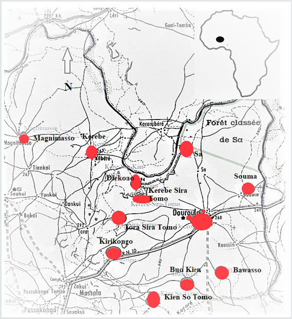
The Mouhoun bend was settled by iron-using communities
in the first millennium BCE (Figure 1, Table 1). The climate was
wetter [1]. The Sudanian savanna and the Mouhoun River offered
a diversified resources mix that allowed for the stabilization
and growth of these mixed farming fishing populations. Their
settlements consisted of multi-mound complexes – moundclusters.
The sample of sites excavated within the Mouhoun Bend
Archaeological Project (MOBAP 1997 – 2000) offers an entry into
the dynamics of this kind of settlement that developed and spread
in the study area for a little more than 2000 years, from ca. 700/500
BCE to 1650 CE (Figure 1, Table 1).
Table 1: Radiocarbon dates from the Mouhoun Bend Archaeological Project.
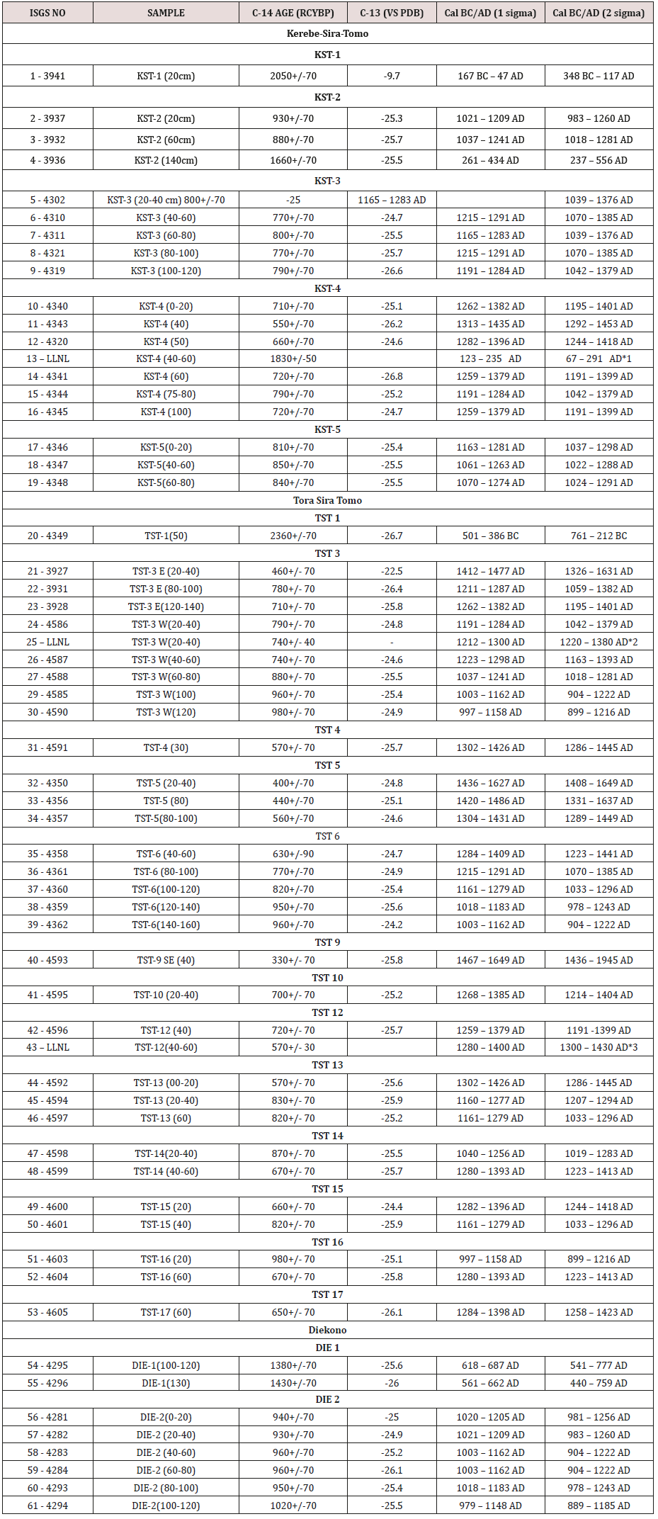
Key: LLNL = Lawrence Livermore National Laboratory:
* Radiocarbon dates from iron objects processed by Dr. Andrea C. Cook at Lawrence Livermore National Laboratory, UC Berkeley.
*1 = from an iron ring
*2 = from a small iron spear
*3 = from a large iron spear
Mounds result from the piling up on the same spot of human
occupation by-products. They include habitation features, craft
installations, collapsed building material as well as discarded
and abandoned material culture. They are therefore exclusively
human-made and, depending on circumstances, can be either well
preserved or significantly disturbed by erosion agencies. These
formation processes that combine cultural (C-transforms) and
natural (N-transforms) are well understood in general [2,3].
Habitation mounds dating from the Late Stone Age onwards are
recorded in different parts of West Africa, from the Chadian basin
to Mali and Guinea [4-18]. They consist either of a single small or
large mound or of multiple mounds (mound-cluster). It has been
suggested that mound-clusters may have derived from residential
segregation, inhabited by different specialized more or less
endogamic groups such as blacksmiths, potters, hunters, fishing
folks, bards, etc. [19,20]. Distinct mounds are thus axiomatically
considered to materialize residential segregation, and as such,
are the signature of craft-specialization. The explanation is
tautological. No excavation program was implemented to test the
accuracy the hypothesis mentioned above. The testing procedure
may have required an appropriate methodology, consisting at least
of the probing of all the mounds part of the settlement complex
under investigation, a precise and fine-grained chronology backing
detailed analyses of material culture, architecture, and subsistence
remains. It is then and only then that variation – or lack thereof
– can be assigned to differences in social status. These principles
have guided the field strategy implemented in the Mouhoun Bend
Archaeological Project [21,22].
The Mouhoun River flows from the SW to NE, winds its course
in a U-shape bend to follow a N-S direction (Figure 1). The study
area located in the Sudano-sahelian zone is delimited in the north
and northeast by the meandering river course. It measures 40km East-West (3o 11’ North / 3o 32’ East) and 38km North-South (12o
30’/ 12o 45’ latitude North). The land, prone to cyclical droughts, is
flat with elevation ranging from 294 to 249m above sea level. The
vegetation is characteristically a highly anthropic wooded savanna,
with the protected shea-butter tree (
Butyrospermum parkii) largely
predominant, followed by different kinds of Acacia sp.
Figure 1: Distribution of archaeological sites in the Mouhoun Bend (Burkina Faso).
Three mound-clusters located in in different environments
were selected for excavation: Diekono in the Mouhoun River floodplain,
Kerebe-Sira-Tomo (KST) on the cliff delimiting the river valley,
and Tora-Sira-Tomo (TST) and its satellite Gnambakouon-Sira-
Tomo (GST) on the topographic rise in the central part of the study
area. Each of the above mentioned sites is comprised of a number of
mounds of different size and shape, iron-working workshops, and
laterite quarries.
The Dynamics of TST and KST Mound-clusters
The long-term pattern of growth of inhabited space within a
mound cannot be assessed with the field methodology implemented
in this case, with one test unit per mound. A general time line of the
settlement complex formation can nonetheless be reconstructed.
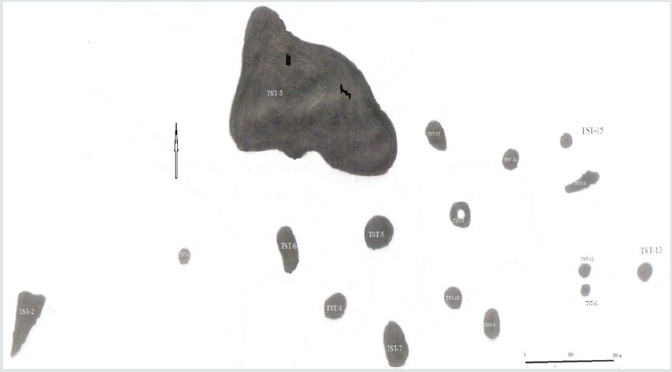
TST settlement complex (12o 35’ 07” N and 3o 22’ 07” E)
is located at 280m asl. With 17 distinct mounds, it is the largest
settlement complex of the study area, spread over 900m westeast
and 500m north-south, some 45ha in total surface extent
(Figure 2). TST-3, the largest mound stretched along the north edge
measures 260m west-east, and 120m north-south. All 17 mounds
were tested after three field seasons (1997, 1999, and 2000). Five,
TST-1 (Iron smelting), TST-2 (quarry), TST-4 (cloth weaving and
dyeing workshop), TST-9 (cemetery), and TST-17 (oil production
workshop), are special purpose sites. The fourteen remaining
ones were standard habitation mounds with varying occupation
intensity
Figure 2: Tora-Sira-Tomo settlement complex.
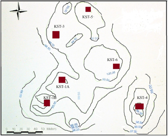
KST settlement complex is located on the cliff top along the
edge of the Mouhoun River valley (Figure 3). The complex consists
of eleven more or less distinct mounds stretched on 350m westeast
and 600m north-south. The cluster is made of three distinct
sites categories: a quarry (KST-2) located at some 800m east,
iron-working stations both smelting and forging, and habitation
mounds. Habitations mounds, clustered in the north, resulted in
the formation of a large 15ha village site. All iron-working stations,
arranged along a roughly ENE-WSW axis, are concentrated at 100
to 200m along the south flank of the main habitation cluster. KST
settlement complex was inhabited from the second half of the first
millennium BC to the second half of the thirteenth-century AD, with
an important 500 years occupation hiatus in the second half of the
1
st millennium AD. The development of TST and KST settlement
complexes can be arranged in four successive phases, from the
middle of the first millennium BC to the middle of the second
millennium AD.
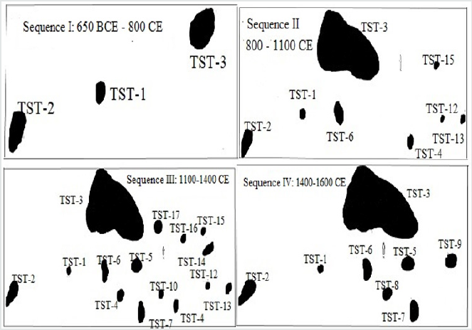
Figure 3: The evolution of TST settlement complex.
Phase I (650 BC-800 AD)
At TST, the initial settlement phase (650 BC-800 AD) that started
in the mid-1
st millennium BC is documented at TST-1, TST-2, and
TST-3-East (Figure 4, Table 2). The earliest occupations are found at
TST-1, an iron-smelting site dated to 650-395 BC (Figure 5), TST-2,
the quarry site that provided raw material for house construction
and iron production, and finally, the blacksmith workshop exposed
at the bottom of TST-3-East probe.
Figure 4: View of TST-1 iron smelting furnace.
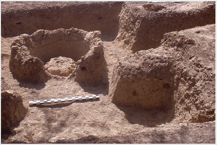
Figure 5: Differential mounds size in m2 during TST phase IV (1400 – 1650 CE).
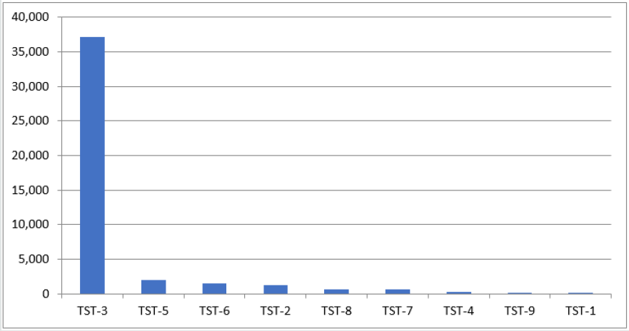
Table 2: Tora-Sira-Tomo mound cluster at Phase I (650 BC – 800 AD).

KST settlement complex phase I dated to 350 BC-150 AD was
shorter. It is documented in the west-central part of the complex,
in KST-1A and KST-2 the quarry site (Figure 6). KST complex grew
in two directions during its phase II dated to 250 – 550 AD. KST-
1B and KST-3 areas were settled. The mound was of an irregular
potato- shape, oriented SW-NE. KST-2, the quarry site, was relied
upon for the supply of iron ore and construction material during
the whole existence of the settlement complex
Figure 6: Kerebe-Sira-Tomo settlement complex.
Phase II (800 – 1100 AD)
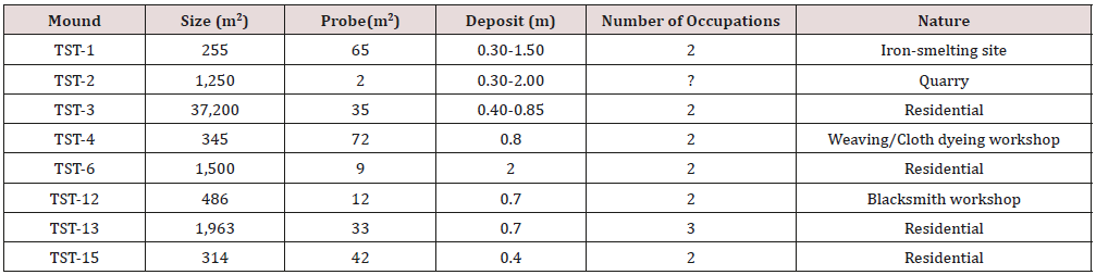
TST Phase II (800-1100 CE) settlement with a total of 8 mounds,
witnessed the foundation of 5 new sites. They were arranged in two
sub-clusters of four sites each: TST-1, TST-2, TST-3, and TST-6 in
the west, and TST-4, TST-12, TST-13, and TST-15 in the east (Figure
4, Table 3). The western sub-cluster consisted of two residential
mounds: TST-3 and TST-6, and two special purpose sites: TST-
1(iron-smelting and ritual) and TST-2 (quarry). The eastern subcluster
includes TST-13 and TST-15 residential sites, and TST-4
(weaving and cloth dyeing workshop) and TST-12 (a blacksmith
workshop) special purpose sites (Holl 2014). KST complex was
abandoned during all the second half of the 1st millennium AD, from
ca. 550 to 1000 AD.
Table 3: Tora-Sira-Tomo mound cluster in Phase II (800 – 1100 AD).
Phase III (1100 – 1400 AD)
TST settlement complex reached its maximum extent during
phase III (1100-1400 AD) with the addition of 7 new sites. All 15
mounds (Figure 4 & 7, Table 4) were located in the space delineated
during phase I and II. The new additions are set in two patterns.
TST-5, TST-7, TST-8, and TST-10 present a rectilinear arrangement
of equidistant mounds at 100m from one to the next. TST-5, TST-
7, and TST-8 residential mounds ‘sits’ on burials dug deep in the
laterite crust in what may have been an earlier cemetery. TST-14,
TST-16, and TST-17 are along the northeastern flank of the complex,
at 100m from one to the next, in a linear east-west arrangement.
TST-14 and TST-16, were residential and TST-17 a karité oil
production workshop.
Table 4: Tora-Sira-Tomo mound cluster in Phase III (1100 – 1400 AD).
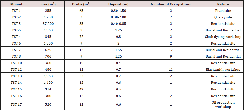
Figure 7: The evolution of KST settlement complex.

KST complex also witnessed an accelerated growth during
Phase III (1000-1250). KST-IA and 1B, KST-2 (quarry site), KST-3,
KST-4 (occupation I and II), KST-5, and KST-6 (Figure 6) were all
inhabited and in use. Fire destroyed habitation units from KST-3
occupation I and KST-4 occupation II (Figure 8 & 9), located along
the southeast flank of the complex. There was also a significant
intensification of iron-working, with the foundation of workshops
devoted to iron-smelting, blow-pipes making, and blacksmithing
along the south margins of the main village.
Phase IV (1400 -1650 AD)
TST settlement complex shrunk significantly during Phase IV
(1400-1650 AD). The number of inhabited sites dropped from 15
to 9. The eastern part of the cluster was abandoned (Table 5, Figure
4). A new restricted access cemetery was founded at TST-9. TST-3,
TST-4, TST-5, TST-6, TST-7, and TST-8, were residential. TST-1, TST-
2, and TST-9, respectively iron-smelting site, quarry, and cemetery,
were special purpose sites. In general, with the exception of TST-
8 set between TST-4 and TST-7 (Figure 4), the distance between
neighboring mounds oscillates around 100m.
An identical phenomenon occurred at KST. The inhabited space
also shrunk considerably during KST phase IV (1250-1450 AD)
(Figure 6). Shallow occupation evidence is documented at KST-4
occupation III and IV, then used as a cemetery.
Figure 8: Partial view of KST phase III domestic unit.
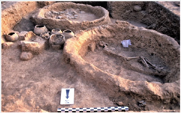
Figure 9: Habitation complexes from Phase III KST-4 .
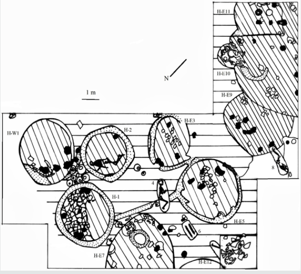
Table 5: Tora-Sira-Tomo mound cluster in Phase IV (1400 – 1650 AD).
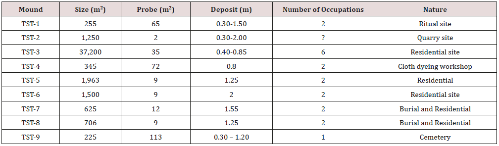
Variability of mounds clustering processes
Data collected from the excavation of four settlement complexes
point to the existence of two main mound-clustering strategies: a
tight and a loose one. KST settlement complex that lasted from ca.
350 BC to 1450 AD, with a half millennium occupation hiatus in
the second half of the 1st millennium AD, features tight-clustering
(Figure 7 & 8). All the residential sites, with the exception of KST-
4, are tightly packed in a 15ha village. Iron-working sites located
along the south periphery of the village display no habitation. Craft
people and work crews were KST villagers who commuted to their
workshops during the iron-production seasons.
TST-GST settlement complex with a total of 20 mounds features
the loose-clustering strategy. The mound-sites, 17 for TST and
3 for GST are well demarcated, with each sub-set presenting a
large dominant mound. Residential and special purpose sites are
represented in varying combinations all along TST settlement
complex occupation history.
Archaeological data indicate that flexible strategies were
adopted by the different ‘self-sustaining’ autonomous ancient
villages during the 2200 years’ occupation of the Mouhoun bend.
In KST, craft people resided in the village and commuted to their
workshops located in the southern outskirts of the complex. In
the TST alternative, with more or less inter-phase variations,
craft people built their residence in distinct places and supplied
local communities from their workshops. There is no fixed and
permanent pattern of residential and occupational segregation in
the analyzed archaeological record [21,22].
Peer-village interaction
The study area is relatively flat. The recorded settlement
complexes are more or less evenly distributed in the landscape.
In site-catchment analysis terms, each village is surrounded by
rings of cultivated fields, fallow zones, and bush [23,24]. At their
peak, during the first centuries of the 2
nd millennium AD, each of
the recorded settlement complex was a large autonomous and selfsustaining
village. Some, like KST and Kirikongo, were compact
villages with a few outlying mounds and special purpose sites.
Others, as was the case for TST – GST and Diekono, were spread out
with a multiplicity of distinct mounds.
There are no significant wealth differences. Grave-goods
and burial offerings are too marginal to be significant. Some
individuals, male, female, children, and infants, were nonetheless
buried in “restricted access” cemeteries while others were buried
in their compounds. This differential treatment points to subtle
variations in social status without detectable and/or durable
material correlates. The accelerated growth at the beginning of the
2
nd millennium AD initiated a scramble for land, villages rivalry,
violence, and wars.
Fire: accidents or wars?
Burnt houses were recorded in some of the excavated mounds.
It is the case at TST-3-West in occupation I and II, dated to 1000-
1150 AD. Domestic installations belonging to two successive
occupations were totally burnt down. KST complex also present
two instances of burnt domestic installations dated to 1050 – 1380
AD: one at KST-3 occupation I and the other at KST-4 occupation II.
In the latter case, a whole household complex with its food supply
was destroyed by fire (Figure 9). Similar cases of burnt installations
dated to 1300-1450 AD were recorded at Kirikongo, Mound III,
level 8 and Mound IV, level 7 [8]. These events took place during a
period of accelerated growth that triggered violent confrontations.
War, Violence and surgery
There is no direct one to one correlation but the unrest indicated
by burnt houses is partly corroborated by traumatic injuries found
on some of the deceased. Two male and female adult individuals
buried in the same context at TST-7 appears to have been victims
of the same violent encounter. One, a 35-50 years old adult female
presents 4 well healed cranial fractures on the occipital, frontal,
and left parietal. The other, an impressive 1.95m tall 45+ years
old male presents two distinct episodes of trauma. He recovered
from previous blows indicated by a well healed circular defect on
the occipital. He has multiple trephinations with no signs of healing
on the right, left parietals and frontal, showing that the second
series of blows was fatal. Remarkably, both adults present similar
blows patterns: they were hit on the frontal, occipital, left and right
parietals, as if the aggressors were well trained fighters [25-27].
The surgery may have taken place after a violent raid. Finally, a
9-11 years old pre-adolescent, individual 18 from phase IV TST-
9 cemetery, presents multiple peri-mortem depressed cranial
features made by a sharp object, that was very likely the cause of
death [26].
The recorded evidence on traumatic injuries is dated to
phase III (1000-1200 AD) and IV (1250-1500 AD) when the area
witnessed a significant growth acceleration followed by the onset
of devolution. There are convincing evidence of conflict and intervillage
warfare during the first half of the second millennium AD.
The nature and characteristics of the kind of warfare that may
have developed in the area during this phase of accelerated growth
are difficult to decipher. The tactics involved may have consisted
of surprise raiding and counter-raiding with the aim of seizing
supplies and host [27-37].
Conclusion
Each village had its autonomous system of government,
with horizontally differentiated groups. These mixed farming
communities included a number of craft specialists, potters, ironsmelters
and blacksmiths, masons, cloths weavers and dyers, karite-oil producers, as well as part-time warriors, and healers
(surgeons). The Mouhoun Bend peer-villages were autonomous
and self-sustaining but not autarkic. A general compatibility of
“worldviews” is suggested by the strong coherence of mortuary
practices. Despite variations, pottery decoration techniques and
syntax suggest a shared cultural universe. The mound-dwellers of
the Mouhoun Bend developed an original socio-political system
that, for approximately two centuries, from 1200 to 1400 AD,
existed on the periphery of the powerful expansionist Mali Empire.